Caversham, New Zealand facts for kids
|
|
||
Caversham is an old and important suburb (or neighbourhood) in Dunedin, a city in New Zealand's South Island. It sits at the edge of the city's main flat area. From here, a steep valley called Caversham Valley goes up to a high point called Lookout Point. Big roads and train lines to the south are very close by. The main railway line for the South Island goes right through Caversham. A special bypass road also helps connect Dunedin's main roads to the Dunedin Southern Motorway. Many bus routes link Caversham to nearby areas and the city centre.
A rich early settler named William Henry Valpy started the suburb in the 1850s. He named it Caversham because his family came from a town called Reading in England, which has a place called Caversham. The suburb grew very fast in the 1860s during the Central Otago Gold Rush. This was because it was on the main path to the gold fields in Otago. By the late 1800s, Caversham had many factories and skilled workers. This, along with its strong Protestant background, made the area lean towards left-wing politics. Caversham used to be its own town until 1904, when it became part of Dunedin city.
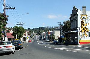
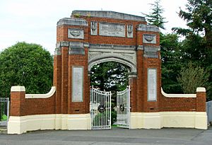
Today, Caversham is mostly a place where people live. There are still some factories, especially the Hillside Railway Workshops in the east. The main shopping area is on South Road and Hillside Road. Important buildings include Lisburn House, which is a historic home, and several old churches. The war memorial for the suburb is actually the main gate of Caversham School, which is now called Carisbrook School. There is also a special school for students with unique learning needs. The closest high schools are about 1 kilometre away in St Clair.
Caversham is well-known for sports. It was home to Carisbrook, a major sports stadium in Dunedin until 2011. The Southern Rugby Football Club is based here, and the suburb gives its name to the Caversham Football Club. Many famous sportspeople have connections to Caversham. These include cricketer Clarrie Grimmett and rugby leaders "Old Vic" and "Young Vic" Cavanagh. Other notable people from Caversham include politician Thomas Kay Sidey and architect Edmund Anscombe.
Contents
Discover Caversham's Location
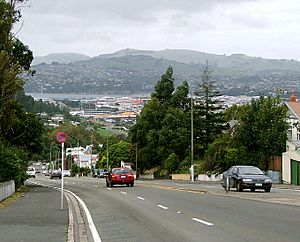
Caversham is in the western part of Dunedin city. It is about 4 kilometres southwest of the city centre. The Pacific Ocean coast at St Clair is only 2 kilometres south.
To the south of Caversham is Calton Hill. This is a part of Forbury Hill, where the suburbs of Calton Hill, Corstorphine, and Kew are found.
Nearby Neighbourhoods
The suburbs of Balaclava and Maryhill are to the north. They are near the western end of the ridge that runs along the north side of central Dunedin. These hills were once part of the Dunedin volcano. Its old crater now forms Otago Harbour. Other nearby suburbs include Forbury, South Dunedin, Kensington, and Lookout Point.
Roads and Railways
The Caversham Valley has always been the main way to get out of the city to the south. The suburb is very close to the start of the Dunedin Southern Motorway. This is part of State Highway 1, the main road into central Dunedin from the south. The South Island Main Trunk railway also runs through Caversham. When the motorway was built, it took traffic away from South Road. South Road used to be the main street through Caversham.
The railway is important for the suburb's biggest industry. This is the Hillside Railway Workshops. They are in the southeast of Caversham and in the next suburb, South Dunedin. Even though the workshops are there, Caversham no longer has any train stations. The last one closed in 1962.
The hills north of Caversham are not as crowded. They still have some trees. These steep hills create a natural barrier between Caversham and Maryhill. Only a few winding roads cross this barrier. Glen Road, at the eastern end of Caversham, is one of them. At this end, the suburb is close to the hills. A natural valley, called "The Glen," makes it easier to reach the hill ridge by road.
Northeast of The Glen, a hill with a 20-metre cliff separates Caversham from the city centre. This hill is sometimes called Montecillo Ridge. It is named after a large house owned by an early settler. It is also sometimes called "Hillside" after Captain William Cargill's house. This ridge looks over "The Flat," which is the plain stretching to the Pacific coast. South Road curves around this hill, connecting to the southern end of Princes Street. One of Dunedin's oldest cemeteries, Dunedin Southern Cemetery, is on the city side of this hill.
What is Lookout Point?
At the top of Caversham Valley is a ridge and a low point called Lookout Point. From Lookout Point, you can see far to the southwest. You can see past the suburbs of Burnside and Green Island to Saddle Hill. You can also see east across the southern part of the city to Otago Harbour and the Otago Peninsula.
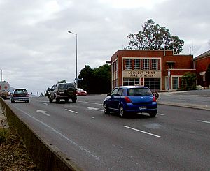
The most noticeable building at Lookout Point is the local fire station. It was built in 1956 and serves Caversham and Green Island. It is a well-known landmark when you enter or leave Dunedin. Not far from the fire station is Dunedin's tallest tree. It is a eucalyptus tree that is about 100 metres tall. The Dunedin Southern Motorway officially starts at Lookout Point. It goes down over the hills past Green Island to Mosgiel and the Taieri Plains.
Lookout Point is also home to the old Caversham Industrial School. It started in 1869 and was later a boys' home. Now, it is a training centre for adults. The main streets at Lookout Point include South Road, Caversham Valley Road, Riselaw Road, and Mornington Road.
The Māori name for Lookout Point is Ko Raka-a-runga-te-raki. It was the burial place of Chief Rangi-Ihia. He was a Kati Mamoe chief from the late 1700s. He helped join the Kai Tahu and Kati Mamoe tribes. He was buried there so his spirit could see his old homes to the south.
A 3.4-hectare forest reserve is on the upper slopes of Caversham Valley. It is below Lookout Point. The Dunedin City Council bought it in 1994 with help from the Royal Forest and Bird Protection Society. It is home to many native birds and invertebrates. This includes a type of velvet worm that is only found in the Dunedin area.
Caversham's Past
William Henry Valpy, a rich early settler, named Caversham. He farmed the land around Forbury Hill. His first farm, "The Forbury," was in what is now St Clair. A street there is now named after him. A member of Valpy's family was born in Caversham, Berkshire, England.
In Dunedin's early days, it was hard for a wagon to reach Caversham Valley in wet weather. Valpy solved this by paying men to build a simple road. It went from the south end of Princes Street to his farm. This road became the basis for later roads into the suburb. The road curved around the hills at The Glen to avoid a big swamp. The Carisbrook sports ground is now on the site of that swamp.
Not many people settled in the area at first. But Caversham Valley was a popular route south from the city. The Central Otago Gold Rush in 1861 changed things fast. Thousands of people started using the road to go to and from the gold fields. The suburb began to grow quickly. The first pub, the Edinburgh Castle Hotel, opened in 1861. By the end of the 1860s, Caversham had its own school and post office. It also had Anglican and Presbyterian churches. A third church, for the Baptist faith, opened in 1872.
Several charities have had buildings in Caversham. These include a home for sick people and an IHC New Zealand centre. The Royal New Zealand Foundation of the Blind still has its Otago office in Hillside Road.
Early businesses in the area included a brickworks and the Caversham Gasworks. The gasworks ran from 1882 to 1909. Its last buildings were a local landmark. They were removed when the Caversham bypass was built in the 1970s and 1980s. Other early businesses in Caversham included breweries, a leather factory, and a match factory.
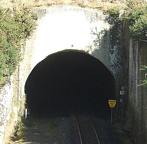
Building the South Island Main Trunk railway south of Dunedin started in 1871. This led to building an 865-metre tunnel under Lookout Point. It connected Caversham with Green Island. A second, parallel 1407-metre tunnel was started in 1907. This was the first double-track tunnel in New Zealand. All trains moved to the new tunnel in 1910. Caversham had its own railway station until it closed in 1962. There has been a long effort to turn the older tunnel into a cycleway. However, this idea has not fully gained council support.
By the 1870s, Caversham's population was growing fast. In 1877, with about 4,000 people, it became a borough (a small town with its own council). It stayed a borough until it joined Dunedin city in 1904. The borough's area included much of what is now Forbury and St Clair. It also stretched to the Pacific coast in the south and Otago Harbour in the east.
The Caversham Project
The early history of Caversham has been studied in a big research project. The University of Otago runs it, and it's called The Caversham Project. For over 30 years, they have collected information about life in early South Dunedin. This project has created a huge database. It is one of the biggest historical studies in New Zealand or Australia. It has helped researchers learn a lot about the people and society of early Dunedin.
This study looks at many different topics. It covers everything from city planning to how men and women lived. By using both numbers and stories from people, it has created a clear picture of early urban New Zealand. Several books have come from this project.
How Caversham is Governed
In its early days, the Caversham Road Board managed Caversham. This group acted like a council until May 1877. Then, Caversham became a borough. The Borough of Caversham lasted until November 1904. It covered a much larger area than the suburb does today. This included parts of Saint Clair, South Dunedin, Kew, and Kensington. It also reached the Pacific coast and Otago Harbour. The names of some of the borough's mayors are remembered in local street names. These include Robert Rutherford, William Bridgman, and Thomas Kay Sidey.
Today, the Dunedin City Council manages Caversham.
At a national level, Caversham was its own voting area (electorate) from 1866 to 1908. Some MPs for this area included Thomas Kay Sidey and future Premier Robert Stout. Since 1908, Caversham has been part of different electorates. Currently, it is in the Taieri electorate. As of 2022, its MP is Ingrid Leary from the Labour party.
Caversham's People
Unlike most of Dunedin, which was settled by Scottish people, many early settlers in Caversham were English. This caused some disagreements between the city and Caversham councils at first. Dunedin was settled by the Presbyterian church. But Caversham's people were mostly Anglican, Methodist, and Baptist. Today, you don't see much of this difference. Only some street names show the English origins of early settlers.
Caversham started as a place for working-class and lower-middle-class people. Many early residents were skilled workers. In its early days, Caversham was known as "The carpenters' borough." This was because many skilled workers there were builders. The mix of people and their Protestant religions led to strong ideas about fairness and helping others in the area's politics.
The area still tends to support left-leaning politics. The Taieri electorate, where Caversham is, often votes for New Zealand Labour Party Members of Parliament.
Many Caversham residents still have a lower income compared to those in the richer hill suburbs. A 2007 report showed that many houses (39%) in the suburb had only one or two bedrooms.
The Caversham area covers 0.71 square kilometres. In 2023, it had about 2,265 people. This means there are about 3,190 people per square kilometre.
| Historical population | ||
|---|---|---|
| Year | Pop. | ±% p.a. |
| 2006 | 2,253 | — |
| 2013 | 2,181 | −0.46% |
| 2018 | 2,265 | +0.76% |
At the 2018 New Zealand census, Caversham had 2,265 people. This was an increase of 84 people (3.9%) since the 2013 census. It was also an increase of 12 people (0.5%) since the 2006 census. There were 1,029 homes. There were 1,053 males and 1,212 females. This means there were 0.87 males for every female. The average age was 43.3 years. About 13.9% of people were under 15 years old. About 20.3% were aged 15 to 29. About 40.9% were aged 30 to 64. And 24.6% were 65 or older.
Most people (81.3%) were European/Pākehā. About 15.1% were Māori. About 7.4% were Pasifika. About 5.6% were Asian. And 2.5% were other ethnicities. People could choose more than one ethnicity.
About 16.0% of people were born overseas. This is lower than the national average of 27.1%.
Many people chose not to answer about their religion. But 50.5% said they had no religion. About 37.4% were Christian. About 0.5% had Māori religious beliefs. About 0.7% were Hindu. About 0.7% were Muslim. About 0.5% were Buddhist. And 2.1% had other religions.
Of those aged 15 or older, 315 people (16.2%) had a university degree or higher. About 510 people (26.2%) had no formal qualifications. The average income was $23,400. This is lower than the national average of $31,800. Only 90 people (4.6%) earned over $70,000. This is much lower than the national average of 17.2%. For those aged 15 or older, 762 people (39.1%) worked full-time. About 267 people (13.7%) worked part-time. And 99 people (5.1%) were unemployed.
Schools in Caversham
Caversham does not have any high schools. But it does have a primary school and a special needs school. Carisbrook School is at the corner of South Road and Surrey Street. It was created in 2012 when Calton Hill School, Caversham School, and College Street School joined together. They all moved to the old Caversham School site, which started in 1921. The school's history goes back to the early 1860s. The school has about 648 students. The original brick buildings from the 1920s were pulled down in 1961 because they were not safe. The school's main gate is the only part left of the old building. It serves as the suburb's war memorial.
The Sara Cohen School is on Rutherford Street. It was started in 1926. This school helps students with special needs. It teaches them from primary school age through adulthood. The school is named after Sara Cohen. She was the wife of Mark Cohen, a city councillor and a supporter of women's rights. He was also the editor of the Evening Star newspaper. In 1889, Mark Cohen helped start New Zealand's first kindergarten.
There are kindergartens and childcare centres in Rutherford Street and South Road. There are also many pre-school places and other primary schools in Forbury and Saint Clair. These suburbs are just south of Caversham. The closest high schools are Queen's High School (for girls) and King's High School (for boys). They are next to each other near the border of Saint Clair and South Dunedin, about 1 kilometre south.
Caversham's Businesses
In its early years, Caversham had many factories and businesses. It also had many homes. The people living there included many skilled workers. Both big and small businesses were common. At the start of the 1900s, local businesses included a brickworks, a gasworks, breweries, and a blacksmith. There were also hat makers, bakeries, a leather factory, and a shoemakers. Rutherford's Wax Vesta match factory was at Forbury Corner. In 1900, the area around South Road, David Street, and Forbury Corner had over 50 businesses.
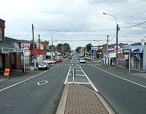
Today, Caversham is mainly a residential area. But it still has some shops and light industrial businesses. The main shopping area is on South Road. It stretches into David Street and the western end of Hillside Road. This area is sometimes called Forbury Corner or Kew Corner. A few shops are also on South Road, about 0.8 kilometres to the east, near Carisbrook. Hillside Road has more light industrial businesses as it gets closer to South Dunedin. These include car mechanics, car sales, joineries, a rope factory, and a funeral parlour. One of Dunedin's largest industrial sites is the Hillside Railway Workshops. It is at the eastern end of Hillside Road. Other smaller factories are nearby. Beyond this is the shopping area of South Dunedin.
Caversham has four pubs now. This is much fewer than in its early days. They are the Carisbrook Hotel, Mitchell's Tavern, the Waterloo Hotel, and the Fitzroy Hotel.
Sports in Caversham
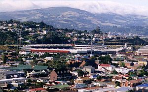
Carisbrook was Dunedin's main stadium for rugby union and Test cricket. It was at the eastern end of the suburb, between The Glen and the Hillside Railway Workshops. It was the home of the Otago Rugby Union until a new stadium opened in North Dunedin in 2011. This new stadium, the Forsyth Barr Stadium at University Plaza, is now the home of Otago Rugby and the Highlanders rugby team. Carisbrook was demolished starting in 2013.
Besides Carisbrook, the main sports ground in Caversham is Bathgate Park. It is on the border of Caversham and South Dunedin in the southeast. There are also several open park areas. These include Kew Park at Forbury Corner and Sidey Park. There are tennis courts near Kew Park and a croquet club. Kew Park is also home to a well-known pétanque club.
Other sports connections include the Caversham Football Club. This is one of Dunedin's most successful football teams. Caversham has reached the semi-finals of the national knockout competition (the Chatham Cup) three times. They were also part of the former New Zealand National Soccer League in the 1970s. They played in the league's last season in 2003. Even though it's called Caversham, the team plays at Tonga Park. This park is in the nearby suburb of Forbury. They share the ground with the Carisbrook-Dunedin Cricket Club. Caversham also has one of Dunedin's main athletics clubs.
The Southern Rugby Football Club is a rugby union club. It is at Bathgate Park in the southeast of Caversham. Southern is often one of Dunedin's strongest club teams. They have won the Otago club championship over 20 times. The club was formed in 1899 when the Caversham and Pacific clubs merged. More than 20 All Blacks (New Zealand's national rugby team) have played for Southern. These include Stephen Bachop, Stu Forster, Jamie Joseph, Laurie Mains, and Gary Seear.
Important Places in Caversham
The Hillside Railway Workshops are a very important landmark. They are in the southeast of Caversham and the next suburb, South Dunedin. These workshops started in 1875. They are the main place in the South Island for building and repairing trains. The workshops cover 8 hectares of land. About 3 hectares of that is covered by buildings.
North of the workshops was Carisbrook, Dunedin's former main sports stadium. It opened in 1883 and could hold 35,000 people. It was used mainly for rugby, but also for other sports like Test cricket. Carisbrook lost its top spot when a new stadium was built in 2011. Demolition of Carisbrook began in 2013. The ground was named after the old home of an early settler, which was named after Carisbrooke Castle in England.
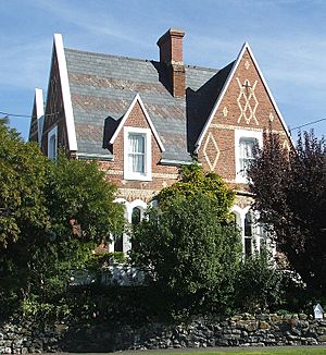
Lisburn House is one of the best 1860s townhouses still standing in New Zealand. It is now a bed and breakfast. This house was built in 1865 for the Fulton family. They were early farmers. The house was named after their hometown of Lisburn in Northern Ireland. It is a Category I heritage listed building. William Clayton designed the 12-room house. It is special for its steep slate roof and colourful brickwork. Two other historic buildings are on Fitzroy Street.
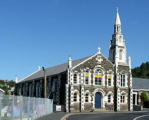
Other important buildings in Caversham are its churches. The Presbyterian church is on Thorn Street. It was built in 1883 after the old building burned down. The current building is made of Port Chalmers bluestone with Oamaru stone details. T. B. Cameron designed it.
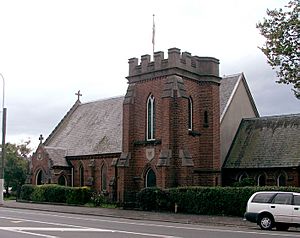
Caversham's Anglican church, St. Peter's, is on Hillside Road. H. F. Hardy designed it, and the first stone was laid in 1882. The original plan included a tall spire. But because of problems with the tower's foundations, it was never built.
Caversham Baptist church is at the corner of South Road and Surrey Street, near Caversham School. This church has a formal Classical style. Its brickwork has pediments and square columns. The first stone for the building was laid in 1906. The old Baptist Church, on Playfair Street, is now used as a Gospel Hall.
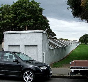
Part of the Donaghy's Industries factory is also notable. It is next to Bathgate Park. This building is less than 4 metres wide but about 380 metres long. It is a ropewalk for Donaghy's. They have been making rope and twine here since 1876.
How to Get Around Caversham
The main road in Caversham is South Road. At its eastern end, it winds around hills. Then it joins Princes Street and Dunedin's city centre. A slip road connects South Road to State Highway 1. This is at the bottom of the hills, just above Carisbrook.
Hillside Road runs parallel to South Road, a few hundred metres south. It is a main road connecting South Dunedin (at its eastern end) with Dunedin's southwestern suburbs. At its western end is Forbury Corner. This is a road junction that links Hillside Road with other main roads. These roads go to Saint Clair (Forbury Road) and Corstorphine (Easther Crescent). David Street is also here, connecting Hillside Road and South Road. Many other small streets run between Hillside Road and South Road. Other main roads in the suburb include Caversham Valley Road, Playfair Street, Surrey Street, and Glen Road. Glen Road is at The Glen, at the eastern end of Caversham. It connects South Road with the hill suburbs of Maryhill, Balaclava, and Mornington.
A Caversham bypass was built in the late 1970s and early 1980s. It opened in 1987. This bypass now carries State Highway 1 away from the main shopping area of the suburb. It connects to the city's one-way street system at its northern end. When the bypass was built, Caversham Valley Road was shortened. The upper part of the road became part of State Highway 1. It connects the bypass with the Dunedin Southern Motorway.
Before the bypass, South Road and Caversham Valley Road were the main way out of Dunedin to the south. State Highway 1 used to follow South Road through the main shopping area. Then it followed Caversham Valley Road to Lookout Point. Above its shopping area, South Road winds around Calton Hill. Caversham Valley Road is a straighter, steep route. It originally continued from the end of South Road's shopping area. Because of this, the part of South Road through the shopping area is sometimes called part of Caversham Valley Road. Work to improve Caversham Valley Road started in 2011. A junction at the north end of Caversham's main shopping area connects South Road with the bypass.
Caversham used to have a train station on the "South Line" between Dunedin and Mosgiel. Train services on this line stopped in 1982. The train station buildings were pulled down a few years later.
Trams served Caversham between 1880 and 1954. They ran on Hillside Road, South Road, and David Street. Now, several bus routes serve Caversham. They connect it with the city centre. Citibus and Dunedin Passenger Transport run routes from the city centre to Saint Clair and Corstorphine via Hillside Road. They also go to Lookout Point via South Road. Dunedin Passenger Transport also runs services between The Octagon and both Mosgiel and Brighton via South Road. Cargill's Corner, at the South Dunedin end of Hillside Road, is a major bus stop.
Notable People from Caversham
Many well-known people have lived in Caversham. This includes members of the Sidey family. Several of them were local or national politicians. One was Thomas Sidey, who was New Zealand's Attorney General from 1928 to 1931. Sidey Park, near the Caversham bypass, and Sidey Street in Corstorphine are named after him.
Captain William Cargill, who founded the Otago settlement, lived just northeast of Caversham. His house, "Hillside," gave its name to Hillside Road. This road was once called Cargill Road. The area around where Cargill's house used to be is still called Hillside. Cargill's Corner, a big road junction in South Dunedin, is also named after him.
Architect Edmund Anscombe lived in Caversham. Anscombe designed many important buildings in New Zealand in the early 1900s. Many of them are still standing today. These include the Sarjeant Art Gallery in Wanganui and the Former Post and Telegraph Building in Wellington. He also worked on buildings in Dunedin, like parts of the University of Otago Clocktower complex and the main building of Otago Girls' High School.
Another notable local resident was surveyor and architect John Turnbull Thomson. Thomson was the Chief Surveyor of the Otago Province from 1856 to 1873. He was also the Surveyor-General of New Zealand from 1876 to 1879. While he was Chief Surveyor, Thomson explored and mapped large parts of the southern South Island. Many places in this area have names that show Thomson's background. Because of this, the area is sometimes called "Thomson's Barnyard" or "The Farmyard Patch."
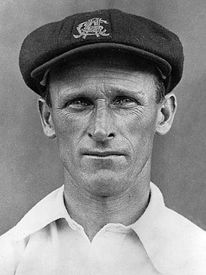
Among sportspeople with Caversham connections, Australian Test cricketer Clarrie Grimmett is very well known. He was named a Wisden Cricketer of the year in 1931. Grimmett was the first player to take 200 Test wickets. He was born in Caversham on Christmas Day, 1891. Famous rugby union leaders "Old Vic" Cavanagh and "Young Vic" Cavanagh were also born in Caversham. This father and son pair changed how rugby union was played with their new coaching ideas.
The cricketer, poet, songwriter, and teacher Robert J. Pope (1865–1949) was also born in Caversham.
 | Emma Amos |
 | Edward Mitchell Bannister |
 | Larry D. Alexander |
 | Ernie Barnes |


