Kensington, New Zealand facts for kids
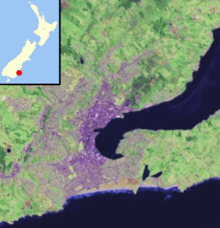
Kensington is a small neighborhood in Dunedin, a city in New Zealand. It's located just south of a hill, between the city center and a larger area called South Dunedin. Kensington is about 2.4 kilometers (1.5 miles) south of Dunedin's main city area. It was likely named after the green and leafy Kensington neighborhood in London. A person named John Hyde Harris helped divide the land here in the 1860s.
Contents
Exploring Kensington
Kensington is built around King Edward Street, which turns into Princes Street nearby. These are two of Dunedin's most important roads. King Edward Street goes south through South Dunedin, while Princes Street heads north into Dunedin's city center.
The Montecillo Ridge and the Oval
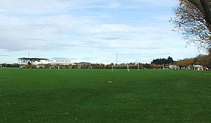
The neighborhood sits at the bottom of a hill called Montecillo Ridge. Close by is a sports field known as the Oval. This large field, about 9.3 hectares (23 acres), used to be called the Southern Recreation Ground. It's now known as the Kensington Oval to avoid confusion with the University Oval in the northern part of the city. Even though it's called an "oval," the field is actually shaped like a triangle! However, it once had a separate oval-shaped cricket ground inside it, which gave it its name.
Green Spaces and History
Above Kensington, on the slope of Montecillo Ridge, is the Dunedin Southern Cemetery. It's separated from Kensington by South Road, which is a main route to Caversham. South Road connects with Princes Street near the Oval. The Oval and the cemetery are part of Dunedin's Town Belt. This is a wide crescent of green spaces that wraps around the central city. It goes through other neighborhoods like Mornington, Belleknowes, Roslyn, Maori Hill, Woodhaugh, and Dunedin North.
The lower parts of Montecillo Ridge were once home to "Hillside," the house of Dunedin's founder, Captain William Cargill. Even though the house is no longer there, its name lives on in Hillside Road in South Dunedin.
Roads and Railways
Kensington is mostly separated from South Dunedin by a bridge and a railway track. This track carries the South Island Main Trunk railway. There used to be a Kensington railway stop right next to the bridge, but it's been closed for a long time.
About 200 meters (650 feet) north of this bridge, a newer flyover carries State Highway 1 through Kensington. However, there are no special ramps (called slip roads) that connect the neighborhood directly to the highway. This flyover divides Kensington into two different parts: a light industrial area to the south and a residential area to the north, at the base of the ridge.
The Army Drill Hall
A well-known building in Kensington is the city's army drill hall. You can find it on Bridgman Street, just south of State Highway 1.
 | Roy Wilkins |
 | John Lewis |
 | Linda Carol Brown |


