Leith Valley facts for kids
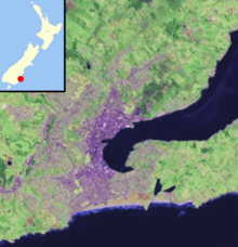
Leith Valley is a suburb, a valley, and a general area in the New Zealand city of Dunedin. It is found to the northwest of the city centre. When people talk about the valley itself, they often say the Leith Valley. When they mean the suburb, they just say Leith Valley.
Contents
The Leith Valley: A Natural Wonder
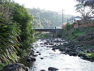
The Leith Valley is named after the Water of Leith. This stream is about 14 kilometres (9 miles) long. It flows from the slopes of Mount Cargill south through Dunedin's northern suburbs.
The valley begins near a flat area called Pigeon Flat. This flat area is between the Leith Valley and the valley of the Waitati River. The Dunedin Northern Motorway crosses this area. The motorway follows the side of Pine Hill, which is part of Mount Cargill. Pine Hill forms the northern edge of the valley. To the south, Maori Hill forms the valley's boundary. This hill is part of a long ridge that curves around central Dunedin.
The valley starts off steep and covered in native bush. Then, it widens into a narrow flat area where Dunedin's suburbs begin. The valley continues to widen, surrounded by steep slopes and cliffs. It eventually joins the wide flat area where Dunedin's main city centre is located. This is about 2 kilometres (1.2 miles) from the coast. At its widest point near the coast, the valley is about 400 metres (1,300 feet) across.
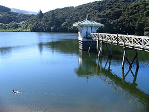
Much of Dunedin's drinking water comes from reservoirs in the upper parts of the Leith Valley. These include Ross Creek Reservoir, which is the oldest working reservoir in New Zealand. Another is Sullivans Dam. Many popular walking tracks go through the bush around these reservoirs.
Leith Valley: The Suburbs
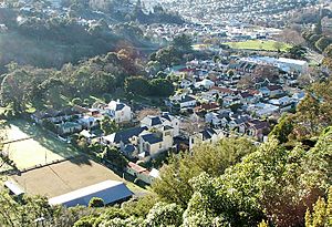
The name "Leith Valley" can mean the small, almost rural settlement in the upper valley. Or, it can mean the whole area, including this settlement and the two suburbs further down: Glenleith and Woodhaugh.
Leith Valley: The Settlement
Leith Valley is more like a rural settlement than a typical suburb. However, it is still inside the Dunedin city limits. It is very close to the edge of the city's main urban area. Leith Valley Road connects this area. This road follows the river and crosses the Dunedin Northern Motorway by a bridge. It then runs alongside the river and motorway before joining the motorway at the Leith Saddle. At its southern end, Leith Valley Road changes into Malvern Street. This is the main road through Glenleith.
Glenleith: A Historic Suburb
Glenleith is one of the main suburban areas in the Leith Valley. It is located in the upper part of the valley. In Dunedin's early days, Glenleith and Woodhaugh were very industrial. The power of the Leith River was used for sawmills starting in 1850. Soon after, flour mills were built. New Zealand's first commercial paper mill was also in the valley. You can still see some overgrown remains of it near a walking track.
Malvern Street is the main road through Glenleith. It runs from Leith Valley Road in the upper valley to Duke Street in Woodhaugh. Most homes in Glenleith are on Malvern Street. Others are around Fulton Road, a steep street that climbs from Malvern Street. It goes through forestry plantations before joining Wakari Road near Helensburgh. Rockside Road is another main road. It runs from Malvern Street near the border of Glenleith and Woodhaugh. It winds uphill through the same plantations and becomes Tanner Road, joining Wakari Road.
These plantations have many walking tracks. They also contain the historically listed Ross Creek Reservoir. This reservoir was built in the late 1860s. The walking tracks go around the dam. They also follow the banks of Ross Creek and School Creek, which are small streams that flow into the Leith.
Another important walking track is the Pineapple Track. Its northeastern end is close to Fulton Road. This track crosses Flagstaff, a 650-metre (2,130-foot) hill. This hill is a major landmark in the city's western skyline.
Woodhaugh: Park and Community
Woodhaugh is the suburban part of the Leith Valley below the Rockside Road intersection. At its top, you can find many old stone buildings, some of which are historically important. Further down, the suburb is dominated by Woodhaugh Gardens. This is a large park with trees and is part of Dunedin's Dunedin Town Belt. This park used to be a quarry. It is one of the city's oldest parks, dating back to 1895.
The area around the park is also called Woodhaugh. It is a popular place for students to live. This is because it is only a 15-minute walk to the university and the city centre. Most homes in Woodhaugh are on Malvern Street. Others are on Woodhaugh Street, a curved street in the upper part of the suburb. There are also a few short streets near the valley's mouth. At this point, Malvern Street becomes Duke Street. Duke Street meets George Street, the city's main shopping street, at the valley's mouth. The only shop in the suburb, a dairy and grocery store, is at the corner of Duke Street and George Street.
A series of walkways goes through Woodhaugh Gardens and along the banks of the Leith River. One path follows the stream from the northern end of Woodhaugh Gardens to connect with the Ross Creek tracks. Along this path, you will see a large weir called the Boulder Trap. This was built to stop big floods like those that happened in the early 1900s. The walkway also passes the remains of the old Woodhaugh Quarry, which closed in 1949.
The sides of the Leith Valley are very steep. This is especially true around the start of Rockside Road. This is also where Ross Creek joins the Leith River. Here, steep cliffs line the valley, and Ross Creek flows through a narrow canyon. In the lower parts of the valley, the walls are still steep but not straight up and down. The Dunedin Northern Motorway runs along the northern edge of the valley, passing by the suburb of Dalmore. Along the southern edge, a walking track climbs steeply. This track, called the Bullock track, connects Woodhaugh with Prospect Park, New Zealand. It was originally a path used by farmers to move cattle from farms in North East Valley to meat processing plants in Burnside, Otago.
Cool Spots in Leith Valley
There are some interesting buildings in the Leith Valley. These include the Ross Creek Reservoir pumphouse. Also, the historic 'Bishop's See House' at 1 Malvern Street, also known as Hawthornden. There's also a former public house (like an old pub) on the corner of Malvern Street and Woodhaugh Street. This building was a public house from 1888 to 1892.
Woodhaugh Gardens is home to the Leith Valley Bowling Club. This is one of the city's main clubs for playing lawn bowls.
A special natural feature in the valley is the glow worm area off Leith Valley Road. You can reach it by following the Nichols Falls walking track, which takes about 40 minutes.
 | William Lucy |
 | Charles Hayes |
 | Cleveland Robinson |


