
St Clair, New Zealand facts for kids
Quick facts for kids St Clair |
|
|---|---|

St Clair Beach
|
|
| Basic information | |
| Local authority | Dunedin |
| Date established | 1850s |
| Land area | 203 ha (0.78 sq mi)* |
| Coordinates | 45°54′40″S 170°29′10″E / 45.91111°S 170.48611°E |
| Population | 2,450 (June 2023) |
|
|
||


St Clair is a green and lively neighbourhood in Dunedin, New Zealand. It sits right on the Pacific Ocean coast, about five kilometres from the city centre. St Clair is built on a flat coastal area and also climbs up the side of a hill called Forbury Hill. In 2001, about 4,179 people lived here.
Contents
Exploring St Clair's Geography
St Clair has two main natural features: St Clair Beach and Forbury Hill. Forbury Hill is a high point that rises 159 metres (522 feet) above the flat land. The top of the hill is home to the St Clair Golf Course.
The sides of Forbury Hill include a large cliff about one kilometre inland from the beach. There's also a rocky point that sticks out into the Pacific Ocean. A small island called White Island is just south of St Clair Beach. The inland cliff, which runs next to Forbury Road, was once a quarry where rocks were dug out. Today, a large retirement village and a church meetinghouse are located near this cliff.
A small stream flows from Forbury Hill. It goes into an underground pipe before reaching the sea at the western end of St Clair Beach. Bedford Street, a main road, follows the steep valley of this stream.
St Clair is surrounded by other suburbs like Corstorphine, Kew, Forbury, and St Kilda. Its main roads include Forbury Road, Bedford Street, Bay View Road, Ravenswood Road, and Allandale Road. There's a small shopping area where Allandale and Forbury Roads meet. Victoria Road connects St Clair to St Kilda. A walkway, called an esplanade, runs along the coast. It has many restaurants and cafes.
St Clair Beach: A Surfer's Paradise
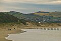
St Clair Beach is the most famous part of the suburb. It's the western end of a long beach called Ocean Beach that stretches along Dunedin's southern coast. This beach is a very popular spot for surfing, and it often hosts national surfing competitions.
The beach at St Clair has a sea wall behind it. Behind the wall is an esplanade with a walking path and a one-way street. The eastern end of the esplanade leads to a path over the sand dunes. These dunes run along the back of the beach all the way to St Kilda.
The beach and dunes often get worn away by storms, especially when strong storms hit from the south. Between 2002 and 2007, sand had to be added to the dunes to protect them. More erosion from 2013 to 2015 caused a public walking path behind the dunes to be closed permanently. This erosion is a big concern for the area. People have been trying to protect the beach since 1904 by adding strong wooden poles and barriers. The last of these wooden posts, which were a landmark, were washed away by 2021. Work is often needed to keep the dunes strong. There is also worry about an old landfill located right behind the dunes, which could cause environmental problems if the erosion continues.
At its western end, St Clair Beach has a small rocky point. Right below this point is the St Clair hot saltwater pool. This outdoor pool is built into a natural rock area, very close to the sea.
Second Beach: A Hidden Gem
Second Beach is a smaller beach located around a rocky point, just southwest of St Clair Beach. It's a rocky beach, not sandy, and is surrounded by natural cliffs that look like an amphitheatre. These cliffs have cool hexagonal basalt columns. These are rare, with only two other places in Dunedin having them.
A popular 1000-metre-long walking track starts behind the St Clair hot saltwater pool. It leads to the cliffs at the top of Forbury Hill, along a ridge behind Second Beach. The path is well-kept and goes through an area that was once a quarry until the 1950s. Now, only old concrete and stone walls remain. The area has been replanted with native plants like tī kōuka, taupata, ngaio, poroporo, hebe, and harakeke. You might also see seals and sea-lions on the beach.
A special feature here is a natural blowhole at the base of Forbury Head. From this spot, you can see amazing views of Dunedin's southern coast and the Pacific coast of Otago Peninsula.
Life in Modern St Clair
St Clair Beach is a popular place for people in Dunedin during summer. It's one of the best surfing spots in the South Island and is home to the St Clair Surf Life Saving Club. The St Clair Hot Salt Water Pool, an outdoor public swimming pool, is nestled among rocks right by the sea. Every year, many brave residents take part in the "midwinter plunge" at the beach during the winter solstice.
The beach's sea wall, esplanade, and oceanway were rebuilt and updated in 2004. In recent years, the esplanade area has become a lively spot with many cafes, restaurants, and bars.
St Clair is one of Dunedin's wealthier suburbs. Many beautiful houses are built on the upper slopes of Forbury Hill. This part of the suburb is sometimes called St Clair Park, perhaps because of the St Clair golf course, which is one of the city's main courses and sits at the top of the hill. Near here are the ruins of Cargill's Castle, a large home built in 1877 for an early settler named Edward Cargill. Today, there isn't much industrial activity in St Clair.
St Clair's Past: A Glimpse into History
We know that Māori lived in the St Clair area before Europeans arrived. Old tools and items have been found near the Esplanade and in the sand dunes. It's also thought that there was a burial site near Cargill's Castle. A major Māori track used to run along the dunes and over Forbury Hill.
The Māori name for the coastal area, including parts of St Kilda and St Clair, was Whakaherekau. This name can mean "To make a friendly gift" or "A trap that caught nothing."
Early European settlers were led by William Henry Valpy (1793–1852). Valpy and his family came to New Zealand in 1849. They set up a 48-hectare (120-acre) farm called "The Forbury." This name came from Forbury Gardens in Reading, England, where Valpy was born. Valpy was said to be the richest man in New Zealand at the time.
Chinese settlers played a big role in St Clair's early days. They helped drain the swampy land inland from the beach and turned it into market gardens. Much of the young city's vegetables came from Chinese gardens near Macandrew Road. Not many people lived in the area until the early 1900s, but the population grew quickly before World War I.
Wealthier residents of the city mostly lived in St Clair. Famous architect Francis Petre designed impressive houses near the beach on Cliffs Road, and two of them are still standing. Important early residents included the Petres, the Cargills, the Sideys (like Sir Thomas Sidey), and the McIndoes. The McIndoe family included John McIndoe, who started a major printing company, and Sir Archibald McIndoe, a pioneer in plastic surgery.
There were also important industries in St Clair's early history, like farming and quarrying. The quarry provided materials for C & W Shiel's brickworks, a very important early industry. The brickworks were on the eastern side of Forbury Road, with the quarry to the west. The quarry is now where the church and retirement village are.
St Clair Beach has been a popular attraction since the city's early days. In 1912, a grand two-story building called a pavilion was built on the esplanade. It was very popular but burned down in 1915. Later, a band rotunda was built there, but it's also gone now.
The cliffs above Second Beach were home to a gun battery, part of a coastal defence system, from the 1880s until the end of World War I. Nothing remains of the battery today.
In May 2013, parts of the esplanade began to collapse, with holes appearing in the walkway. The walls built in 2004 to block the sea were leaking. The Esplanade was repaired, but the sand dunes to the east continue to erode. This erosion threatens the homes near the coast in the long term.
St Clair's Population and People
St Clair covers about 2.03 square kilometres (0.78 sq mi). As of June 2023, it has an estimated population of 2,450. This means there are about 1207 people per square kilometre.
At the 2018 New Zealand census, St Clair had 2,346 people. This number was about the same as in 2013 and slightly less than in 2006. There were 897 households, with 1,119 males and 1,227 females. The average age was 44.7 years. About 17.3% of people were under 15, and 18.7% were 65 or older.
Most people in St Clair (90.5%) were European/Pākehā. Other groups included 9.7% Māori, 3.2% Pasifika, 4.9% Asian, and 3.1% other ethnicities. About 21.7% of people were born overseas.
When asked about religion, 55.8% said they had no religion. 36.3% were Christian, and smaller numbers followed other religions.
Many adults in St Clair had higher education. About 38.3% had a bachelor's degree or higher. The average income was $40,500. Most adults (51.0%) worked full-time.
Learning in St Clair: Schools and Education
St Clair School is a public primary school for students in years 1 to 6. It has 352 students and was founded in 1896. The two single-sex high schools, King's (for boys) and Queen's (for girls), are located nearby.
There are also several kindergartens and childcare centres in and around St Clair. The main office for Dunedin Kindergartens is on Forbury Road, just north of St Clair.
Images for kids
-
St Clair Beach
