Forbury, New Zealand facts for kids
Quick facts for kids
Forbury
|
|
|---|---|
|
Suburb
|
|

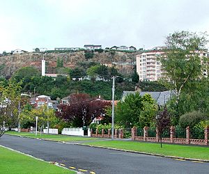
The Frances Hodgkins Retirement Village and the spire of Dunedin's LDS Church lie to the west of Forbury Road, as seen from Wilson Avenue, Forbury
|
|
| Country | New Zealand |
| Local authority | Dunedin |
| Area | |
| • Land | 56 ha (138 acre) |
| Population
(June 2023)
|
|
| • Total | 1,350 |
|
|
||
Forbury is a small neighbourhood in the city of Dunedin, New Zealand. It's about 3 kilometres (2 miles) south-southwest of the city centre. Forbury is located just north of St Clair and sits between St Clair and Caversham.
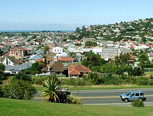
This area is quite low-lying. It was originally marshy land that was drained and developed in the late 1800s. Because of this, Forbury can sometimes experience flooding. It's at the northwest edge of a flat area called "The Flat," which stretches across South Dunedin and St Kilda. To the northwest, the land rises into Caversham Valley. To the west, there's a steep cliff about one kilometre (0.6 miles) inland from St Clair Beach. Forbury extends east from this cliff across the flat land towards South Dunedin. Besides Caversham and St Clair, Forbury is bordered by St Kilda to the south, Kew to the west, and South Dunedin to the east.
The name "Forbury" can be a bit confusing. It's used for several local places, and not all of them are actually inside the Forbury suburb. For example, the old Forbury Park Raceway, a famous horse-racing track, is actually in St Kilda. Also, Forbury Corner, an important road intersection, is in Caversham, though it's very close to Forbury's northern border.
Contents
What to Find in Forbury
Forbury is home to several important places. You can find Tonga Park, a sports field used by the Caversham Football Club. The suburb also has two well-known single-sex high schools: King's High School for boys and Queen's High School for girls.
Forbury Road is the main street in the suburb. It runs mostly north-south, connecting Caversham at Forbury Corner with St Clair at the Esplanade. Other important roads include Bay View Road, Macandrew Road, Surrey Street, and Easther Crescent. Dunedin's main LDS church is near the cliff on the western side of the suburb. One of the city's main retirement villages, the Frances Hodgkins Retirement Village, is built against the cliff just north of the church.
Forbury's Past: A Brief History
Before Europeans settled in New Zealand, the Forbury area wasn't a permanent home for people. However, several walking paths crossed "The Flat." The first non-native settlers were the Valpy family, who arrived in Otago in January 1849. They started farms along the western edge of The Flat. These farms, named Caversham and The Forbury, were named by William Henry Valpy after places near his old home in Reading, England.
The Valpys were among the richest people in the new colony. They built a road, first called "Valpy's Track," between Dunedin and their farm. This road followed a path similar to today's Hillside and Forbury Roads. The Valpy family, along with their servants and workers, created a small community near what is now the northern part of St Clair. Another notable family in the area was the McIndoe family. Their descendants included the famous plastic surgeon Archibald McIndoe.
How the Land Changed
Much of the swampy land along Valpy's Track in the Forbury area was drained and used by Chinese market gardeners. Many of them rented land from the Valpys and McIndoes. Many Chinese people had come to Otago during the Central Otago gold rush. Before their work, the flat land was mostly covered with flax plants and ferns. However, as they dug, they found a lot of evidence that the area had once been heavily forested. These market gardens stretched across much of Forbury, including what is now Tonga Park, and from Kircaldy Street in St Kilda to Forbury Road.
Even though Forbury is mostly a residential area now, it wasn't always that way. One of Otago's main quarries, Shiel's Brickmaking, operated near the cliff west of Forbury Road from 1901 until the 1930s.
People and Population
Forbury covers an area of about 0.56 square kilometres (0.22 square miles). As of 2023, it has an estimated population of 1,350. This means there are about 2411 people living in each square kilometre.
In 2018, the population of Forbury was 1,326 people. This was a small increase from previous years. There were more females (693) than males (633). The average age of people living in Forbury was 38.1 years. About 1 in 5 people (19.7%) were under 15 years old.
Most people in Forbury (79.9%) are of European descent. Other groups include Māori (13.8%), Pasifika (7.9%), and Asian (8.1%). About 18.6% of the people living in Forbury were born outside New Zealand.
When it comes to religion, about half of the people (52.5%) said they had no religion. Many others were Christian (35.1%). Smaller numbers followed other religions like Hinduism, Islam, or Buddhism.
Schools in Forbury
Forbury is home to several schools.
- King's High School and Queen's High School are secondary schools for years 9 to 13. King's is for boys and Queen's is for girls. King's opened in 1936, and Queen's opened in 1955.
- Bathgate Park School is a state primary school for years 1 to 8. It was created in 2012 when Forbury School and Macandrew Intermediate joined together.
- St Bernadette's School is a Catholic primary school for years 1 to 6.
- Forbury also has several kindergartens, which are preschools for younger children. The main office for all Dunedin Kindergartens is located in Forbury on Forbury Road.
 | Victor J. Glover |
 | Yvonne Cagle |
 | Jeanette Epps |
 | Bernard A. Harris Jr. |


