Corstorphine, New Zealand facts for kids
Quick facts for kids
Corstorphine
|
|
|---|---|
|
Suburb
|
|

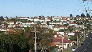
State housing in Corstorphine
|
|
| Country | New Zealand |
| Local authority | Dunedin |
| Area | |
| • Land | 157 ha (388 acre) |
| Population
(June 2023)
|
|
| • Total | 3,850 |
|
|
||
Corstorphine is a suburb in the southwest part of Dunedin, a city in New Zealand's South Island. It sits on the side of Calton Hill, which is part of Forbury Hill. This area is nestled between Caversham Valley and the big Pacific Ocean. Nearby suburbs include Saint Clair and Forbury to the east and south. Caversham and Lookout Point are to the north.
Contents
Exploring Corstorphine's Location
Corstorphine is mostly a place where people live. Many homes here are 'state houses,' which were built by the government between the 1930s and 1960s. The main roads in Corstorphine are Middleton Road, Sidey Street, Riselaw Road, and Corstorphine Road. You can find a small group of shops at the top of Middleton Road.
Connecting to Nearby Areas
To the west of Corstorphine, you'll find mostly rural land. You can reach Green Island and Waldronville through Blackhead Road and Green Island Bush Road. A popular spot called Tunnel Beach is about 1.5 kilometers from the top of Middleton Road. You get there by taking Blackhead Road. North of Corstorphine is the smaller suburb of Calton Hill. Riselaw Road connects Corstorphine to the upper Caversham Valley and Lookout Point.
The Story Behind Corstorphine's Name
The name "Corstorphine" comes from the house and land owned by an early settler named John Sidey. He arrived in Dunedin in 1848. The name itself comes from Corstorphine, a village near Edinburgh in Scotland. Even though the names are the same, they are said differently. The Scottish village puts the stress on the second part of the word, not the first. Many streets in Corstorphine and Kew have Scottish names, like Skibo Street, Dornoch Street, and Lockerbie Street.
Corstorphine House and Sir Thomas Sidey
John Sidey's son, Sir Thomas Sidey, became an important local and national politician in the late 1800s. Sidey's home, Corstorphine House, was built in 1864. It was made much bigger in 1910. This house is one of the suburb's most important landmarks.
Discovering the Suburb of Kew
On the lower slopes of Corstorphine, you'll find a smaller suburb called Kew. Here, a road called Easther Crescent runs along a flat area at the edge of the hill. This road was named after the first house owner in the area, a naval captain. Easther Crescent connects with Saint Clair at Allandale Road to the south. It also goes down to Forbury Corner and Caversham in the northeast.
Kew Park and Its Origins
Kew Park is located at Forbury Corner, which is a big road junction in the suburbs. The area just above the park is sometimes called Kew Rise. The name "Kew" comes from the famous Kew Botanical Gardens in London. This suburb was built on land that used to be part of John Sidey's farm. Kew was always planned to be a place just for homes, so it doesn't have any shops or businesses.
Corstorphine's Community and People
Corstorphine, including Kew, covers about 1.57 square kilometers. As of 2023, it has an estimated population of about 3,600 people. This means there are around 2,300 people living in each square kilometer.
| Historical population | ||
|---|---|---|
| Year | Pop. | ±% p.a. |
| 2006 | 3,357 | — |
| 2013 | 3,510 | +0.64% |
| 2018 | 3,618 | +0.61% |
In the 2018 New Zealand census, Corstorphine had 3,618 residents. This was an increase of 108 people since the 2013 census. It was also an increase of 261 people since the 2006 census. There were 1,515 households in the area. The population included 1,716 males and 1,902 females. About 717 people (almost 20%) were under 15 years old.
Diversity in Corstorphine
The people living in Corstorphine come from many different backgrounds. About 84.7% of residents are European or Pākehā. Around 10.4% are Māori, and 5.7% are Pasifika. About 7.4% are Asian, and 3.2% belong to other ethnic groups. Some people identify with more than one ethnicity. About 19% of the people in Corstorphine were born outside New Zealand. This is lower than the national average of 27.1%.
Beliefs and Work in the Community
When asked about their religious beliefs, 52.5% of people said they had no religion. About 35.2% were Christian. Smaller numbers followed Māori religious beliefs, Hinduism, Islam, Buddhism, or other religions.
For those aged 15 and older, about 26.5% had a university degree or higher. About 19.8% had no formal qualifications. Around 12.7% of people earned over $70,000 a year. This is less than the national average of 17.2%. About 44.8% of people aged 15 and over worked full-time. Another 14.9% worked part-time, and 3.7% were unemployed.
Education in Corstorphine
Corstorphine School was a primary school for students in years 1 to 6. It opened in 1950. However, it closed in 2010 because fewer students were attending. The land where the school was located was sold in 2014.


