Caversham, Reading facts for kids
Quick facts for kids Caversham |
|
|---|---|
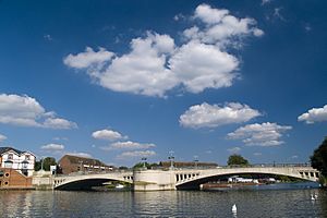 Caversham Bridge |
|
| Area | 6.64 km2 (2.56 sq mi) |
| Population | 23,885 (2011 census) |
| • Density | 3,597/km2 (9,320/sq mi) |
| OS grid reference | SU7174 |
| Unitary authority | |
| Ceremonial county | |
| Region | |
| Country | England |
| Sovereign state | United Kingdom |
| Post town | Reading |
| Postcode district | RG4 |
| Dialling code | 0118 |
| Police | Thames Valley |
| Fire | Royal Berkshire |
| Ambulance | South Central |
| EU Parliament | South East England |
| UK Parliament |
|
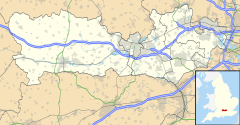
Caversham is a lively area in Berkshire, England. It's like a village and a part of the bigger town of Reading. You'll find Caversham just north of Reading town centre, right across the famous River Thames.
Caversham sits on land that rises up from the River Thames. It includes some flat areas near the river and the lower parts of the Chiltern Hills. Two road bridges, like Caversham Bridge, and two walking bridges connect Caversham to the rest of Reading. Some well-known parts of Caversham are Emmer Green, Lower Caversham, Caversham Heights, and Caversham Park Village.
Cool places to visit include Caversham Court, which is a public park that used to be a big country house. There are also the Caversham Lakes and a part of the Thames Path National Trail, which is a long walking route along the river.
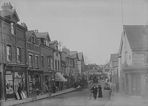
Caversham was first written about in 1086. Back then, it was a village in the Henley area of Oxfordshire. Most of Caversham grew bigger in the 1900s, except for the very centre and Emmer Green, which were already old villages. In 1911, Caversham became part of Berkshire and joined the town of Reading.
Contents
Caversham's Past
Early Days
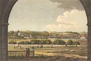
The very first time Caversham was mentioned in writing was in the Domesday Book in 1086. This old book listed everything in England! It called the area "Cavesham" and showed that it was already a good-sized community with lots of farmed land.
Later, in the 1200s, a brave leader named William Marshal, who helped rule England for young King Henry III, passed away in Caversham.
Important Shrine
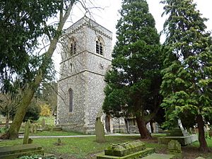
Before 1106, a special place of worship, called a shrine to the Virgin Mary, was set up in Caversham. We don't know exactly where it was, but it might have been near the current St Peter's Church. This shrine became a very popular place for pilgrimage, where people would travel to visit it.
There was also a small chapel on the bridge dedicated to St. Anne and her well. People believed the water from this well could heal them. By the 1400s, the statue at the shrine was even covered in silver! Catherine of Aragon, a queen of England, visited it in 1532. Sadly, the shrine was destroyed in 1538 by order of Henry VIII. Only the well remains today, but it's dry. A new shrine has been created at the local Roman Catholic Church of Our Lady and St. Anne.
Civil War Times
During the English Civil War in April 1643, there was fierce fighting around Caversham Bridge. The town of Reading was held by the Royalists (who supported the King), and they were being attacked by the Parliamentarians (who supported Parliament). Royalist soldiers marched from Oxford to help Reading, but they were badly beaten. Reading then fell to the Parliamentarians a few days later.
The old fortified house in Caversham was replaced by Caversham House in the 1500s. The current Caversham Park House was built in 1850. For many years, from 1943 to 2018, it was home to BBC Monitoring, which listened to news from all over the world. The BBC Written Archives Centre is still there today.
How Caversham is Governed
Caversham is part of the borough of Reading. This means it's managed by the Reading Borough Council. Caversham makes up all or part of four local voting areas, called "wards": Caversham, Caversham Heights, Emmer Green, and Thames wards.
Caversham is also part of the Reading Central area for the UK Parliament. Your local Member of Parliament (MP) for this area is Matt Rodda from the Labour Party.
Local Government
Caversham used to be a separate old parish in Oxfordshire. But in 1911, it officially became part of Reading and moved into Berkshire. This meant Caversham no longer had its own local council. Instead, it became a part of the bigger Reading borough.
Caversham's Location and Landscape
The main shopping area and homes in Central Caversham are surrounded by newer parts of the area. These include Caversham Heights on the higher ground to the west, Lower Caversham to the south-east, and Caversham Park Village to the north-east. Emmer Green is an older village to the north, but it's usually thought of as part of Caversham now.
Different Parts of Caversham
The height of homes in Caversham varies a lot. Some are just 37 metres (about 121 feet) above sea level, while others are 92 metres (about 302 feet) high at the top of Caversham Park. The land on the north side of the River Thames is higher than the land on the south side. This gives people great views to the south.
Natural Beauty
You can walk along the Thames Path National Trail on the riverbank, except for a small part to the west of Caversham. On the northern edge of Caversham, you'll find Clayfield Copse, which is a special Local nature reserve. In the centre of the village, there's a lovely carved Caversham village sign on a tall Oak post, made by a local artist.
Getting Around Caversham
There are several ways to cross the River Thames in Caversham. These include Caversham Bridge, Reading Bridge, and Christchurch Bridge. The last two are just for people walking. Caversham Lock also lets boats pass through. A few miles east, you can also use Sonning Bridge. Even though Caversham doesn't have its own train station, Reading railway station is just a short walk from both Reading Bridge and Caversham Bridge.
Schools in Caversham
Caversham has one public secondary school called Highdown School. Many children from the area also go to Maiden Erlegh Chiltern Edge in South Oxfordshire.
For private schools, Queen Anne's School teaches girls aged 11 to 18. Hemdean House School has mixed classes for younger children and a girls' senior school. There's also Caversham Preparatory School for children aged 3 to 11.
There are several primary schools in Caversham, including:
- Caversham Primary School
- Caversham Park Primary School
- Emmer Green Primary School
- The Hill Primary School
- St. Anne's RC Primary School
- St. Martin's RC Primary School
- Micklands Primary School
- Thameside Primary School
Finding School Places
Sometimes, it's hard to find enough primary school places in the west of Caversham. A new school, The Heights Primary School, opened in 2014 in a temporary building. It's still looking for a permanent home. There have been some discussions about using a small part of Mapledurham playing fields for the school. This would mean kids could walk to school, and the playing fields would be used more by the community.
Caversham also has several nursery schools for very young children. New Bridge Nursery School was even rated "outstanding" by Ofsted in 2011. Chiltern College used to train childminders and now teaches all about childcare. It's special because it has its own nurseries, school, and training college all on one campus.
Sports and Fun
Caversham AFC is one of the biggest youth football clubs in the area. Many of its boys' and girls' teams play in the top leagues. Their main ground is Clayfield Copse, which they call "Swan's Lair" because their team mascot is a swan. Caversham AFC's colours are red and black.
Their main rivals are Caversham Trents FC, who also have boys' teams. Their colours are blue and white, and they often use Mapledurham Playing Fields. The Albert Road recreation ground offers places to play tennis, croquet, and bowls.
Places of Worship
There are many Anglican churches in Caversham. St Peter's is the main church for the Caversham, Thameside, and Mapledurham area. This area also includes St John's and St Margaret's churches in the nearby village of Mapledurham.
You can also find two Methodist Churches, the Catholic church of Our Lady and St. Anne, Caversham Baptist Church, Grace Church Caversham (which is part of Newfrontiers), and the Pentacostal New Testament Church of God. Caversham Evangelical Church meets at the Youth and Community Centre in Emmer Green.
Famous People from Caversham
- Fran Kirby
 | James Van Der Zee |
 | Alma Thomas |
 | Ellis Wilson |
 | Margaret Taylor-Burroughs |


