Ngaio, New Zealand facts for kids
Quick facts for kids
Ngaio
|
|
|---|---|
|
Suburb
|
|

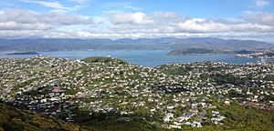
Ngaio, as seen from the hills above Ngaio.
|
|
| Country | New Zealand |
| Local authority | Wellington City |
| Electoral ward |
|
| Established | 1908 |
| Area | |
| • Land | 219 ha (541 acre) |
| Population
(June 2023)Template:NZ population data 2022 SA2
|
|
| • Total | 5,610 |
| Postcode(s) |
6035
|
| Railway station(s) | Ngaio, Awarua Street |
|
|
||
Ngaio is a lovely suburb located in Wellington, the capital city of New Zealand. It sits on the side of Mount Kaukau, about 3.5 kilometers north of the city center. Ngaio was first settled in the 1840s. Many of its streets are named after the early families who lived there.
This area was once a place where people cut down trees for wood. It was first called Upper Kaiwarra, then Crofton until 1908. Ngaio used to be part of a separate local council called the Onslow Borough Council. This council joined with Wellington City in 1919. The name Ngaio comes from a native New Zealand tree called the ngaio.
Contents
Things to Do in Ngaio
Ngaio has many useful places for its residents. You can find a library, a community hall, a pharmacy, and a petrol station. There's also a café, a dentist, and a medical center. You can also find tennis courts and a few small shops.
The houses in Ngaio are a mix of old and new. Some original colonial buildings from the 1860s are still standing. There are also railway cottages and bungalows from the 1920s and 30s. You can also see weatherboard houses built in the 1960s. The Tarikaka Settlement is a special area with old railway cottages built in 1928. These cottages are on streets like Tarikaka Street and Bombay Street.
Ngaio's Library
The Cummings Park Library is part of Wellington City Libraries. It is located at the south entrance of Cummings Park on Ottawa Road. The library opened in 1989 and was updated in 2008. Its entrance has 850 special tiles. These tiles were made by local potters and decorated by children from Ngaio and Chartwell Schools.
The library's Māori name is Korimako. This name comes from the Korimako stream that flows through Ngaio. The library offers free internet access and Wi-Fi. You can also use computers for word processing, printing, and faxing. The library has a special collection of local oral history. This collection shares memories from important Ngaio locals.
The library also hosts regular programs for young children. These include "Baby Rock & Rhyme" for babies up to 2 years old. There's also storytime for children aged 3 to 4. A monthly storytime in te reo Māori is available for children aged 2 to 6.
Ngaio Town Hall
The Ngaio town hall is a place for many community activities. It hosts sports, performances, and cultural events. The hall has a stage, a kitchen, and a drop-in center. It also houses the Ngaio toy library. The hall can hold up to 300 people. It has an easy-access ramp at the front. The hall first opened in 1924 and was renovated in 1989.
Many groups use the hall regularly. These include:
- Bodh Gaya Buddhist Centre
- Ngaio Badminton Club
- Ngaio Drop In Centre
- Ngaio Toy Library
- Onslow Table Tennis Club
Sometimes, there is also a book sale here. It is organized by the Blue Dragon Children's Foundation. This group helps children in need.
Parks and Green Spaces
Trelissick Park stretches from the Ngaio Gorge road. It reaches into nearby Wadestown and Crofton Downs. This park helps connect nature areas between the Harbour and the northern suburbs. The park has old gunpowder magazines built in the 1870s. These were used to store gunpowder.
The park has some original forest areas. A group called the Trelissick Park Group has been working to restore the park since 1991. They have planted over 80,000 trees. They also remove weeds, trap pests, and build bridges.
Orleans Makererua reserve runs from Makererua Street to Orleans Street. It still has parts of the native bush that once covered all of Ngaio. Cummings Park is off Ottawa Road. It has a playground for children and an area where dogs can exercise.
Getting Around Ngaio
Ngaio is connected to the city center by the Johnsonville Branch railway. This train line helps people travel to and from Wellington. There are two train stations in Ngaio: Ngaio railway station and Awarua Street railway station.
Buses also run through Ngaio. Routes 25 and 26 serve the area. Route 22 is operated by NZ Bus.
Ngaio Gorge Road
Ngaio Gorge is the main road that connects Ngaio to Wellington city. It is a very important route, especially if there's an earthquake. This road is seen as a "primary access road" for the Onslow area. It is also a "critical escape route" from the city if other roads become blocked.
In July 2017, heavy rains caused a large landslide. Big rocks and dirt covered the road completely. Over the next few weeks, 3500 cubic meters of rubble were cleared. A temporary wall, 42 meters long and made of shipping containers, was put in place. This wall helps protect the road from more landslides. A temporary road was also built next to Trelissick Park. This helped uphill traffic when the main road was reduced to one lane. The Wellington City Council planned to make the shipping container wall longer. This was to prepare for a permanent solution to be built later.
People of Ngaio
| Historical population | ||
|---|---|---|
| Year | Pop. | ±% p.a. |
| 2006 | 5,259 | — |
| 2013 | 5,499 | +0.64% |
| 2018 | 5,634 | +0.49% |
Ngaio is made up of two statistical areas: Ngaio North and Ngaio South. The total population of Ngaio is about 5,600 people. This means there are about 2,500 people living in each square kilometer.
In 2018, there were 5,634 people living in Ngaio. This was a small increase from 2013. There were slightly more females than males. About 22% of the people were under 15 years old. Most people were between 30 and 64 years old.
Most people in Ngaio are of European descent (89.1%). There are also people of Māori (6.4%), Pasifika (1.7%), and Asian (7.9%) backgrounds. About 23.4% of people in Ngaio were born overseas.
When asked about their religion, most people (60.6%) said they had no religion. About 29.2% were Christian. Smaller numbers of people followed other religions like Hinduism, Islam, and Buddhism.
Many adults in Ngaio have a university degree or higher (56.0%). A large number of people (42.2%) earned over $70,000. Most adults (60.9%) work full-time.
Learning in Ngaio
School Zones
Children living in Ngaio can attend several schools. These include Wellington Girls' College, Onslow College, St Oran's College, and Raroa Normal Intermediate. They can also attend Ngaio School.
Ngaio Primary School
Ngaio School is a state primary school for students in years 1 to 6. It opened in 1908. In 1928, it moved to its current spot on 45 Abbott Street. The school does not have a uniform. Its school song is "Tūrangawaewae," which means "A Place to Stand" in Māori. Ngaio School also acts as a Civil defense center. It helps provide support and information to the community during emergencies.
Pre-school Options
For younger children, Ngaio has several pre-schools. These include Ngaio Kindergarten, Ngaio Playcentre, Ngaio Childspace, Grace Kindergarten, Trelissick Preschool, and Te Kohanga Reo o Ngaio.
Churches in Ngaio
Ngaio has three churches. The Ngaio Union Church has modern buildings. It serves the Methodist and Presbyterian communities. The Anglican All Saints Church has a unique brick tower. You can see it from most parts of Ngaio. It was designed by a famous church architect, Frederick de Jersey Clere, and built in 1928. In 2011, All Saints Church had to close. Engineers said it was at risk from earthquakes after the 2011 Christchurch earthquake. There is also the Onslow Community Church. It has a newly built modern hall on Ngatoto Street, near the border of Ngaio and Khandallah.
Ngaio's Past
Before 1840: Tarikākā
The area where Ngaio is today was originally called 'Tarikākā' by Māori people. This name means 'nest of the kākā'. The kākā is a noisy parrot that used to live in the area. Māori people did not live permanently in this specific spot. However, many Māori tracks ran through the area. One of these tracks became the Old Porirua Road. Another track led to the ancient Ohariu Pā (a fortified village) on Mākara Beach.
1840–1858: Upper Kaiwharawhara
In the 1840s, the area was named Upper Kaiwharawhara. Captain Edward Daniell bought 2,500 acres of land here. In 1845, Daniell built a house near what is now Trelissick Crescent. He named it "Trelissick" after his family home in England. Daniell also built the 'Bridle Trail'. This trail is now part of the Old Porirua Road. It was the original road leading north from his property down to the harbor.
In 1842, Daniell made an agreement with four sawyers (people who cut wood). They built the Kaiwara saw mill on his land. The mill was near where Crofton Road and Kenya Street meet today. A new road built off Old Porirua Road was named 'Captain Edward Daniell Drive' to honor him.
The mill was taken over by John Chew in 1863. He built a cottage using local wood like tōtara, rimu, and kauri. Chew Cottage is still standing today at 19 Ottawa Road. This road is now the main road in Ngaio. It started as the track for John Chew's timber.
1858: Crofton
In 1858, the area was renamed Crofton. This name came from a house built by Sir William Fox on Kenya Street. Sir William Fox later became the Premier of New Zealand three times. In 1862, Fox sold his land and house to Charles Abraham, who was the Bishop of Wellington. It was then sold to Henry Woodford St Hill, an Anglican minister. He turned it into an Anglican boarding school called Crofton College. The school had students from important Wellington families. The school closed around 1875. The building that was Crofton College is still used today at 21 Kenya Street.
1886: The Railway Arrives
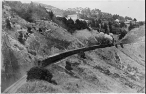
The railway line to Wellington opened in 1886. This made it possible for people to travel easily to the city for work. The train line was updated in 1938. It became electric, making trains more frequent and faster.
1870–1890: The Toll Gate Dispute
The Kaiwara Road (also known as Ngaio Gorge Road) was built in 1850. It allowed bullock trains to carry wool and wood. In the mid-1870s, the Hutt City Council built a toll gate at the harbor end of the road. This was the only way in or out of the area. Money collected from the gate was supposed to be used to fix the road. However, residents felt the money was being used for roads further north. The Kaiwarra road remained in poor condition.
The dispute began when firefighters had to pay the toll after returning from a fire. About 150 people signed a petition. Some people even went to court for refusing to pay the toll. The toll gate was destroyed twice by angry groups. Finally, in 1890, the residents broke away from the Hutt City Council. They formed the Onslow Borough Council. This new council included Kaiwarra, Khandallah, Wadestown, and Ngaio.
1890: Onslow Borough
Ngaio was part of the new Onslow Borough from 1890 until 1919. The borough then joined with Wellington City after a vote on March 31, 1919. The Borough was named after Lord William Hillier Onslow. He was the Governor of New Zealand at the time. This name was chosen to calm his family. They were upset about the city's cleanliness after his young son got sick. The Borough included the towns of Kaiwarra, Khandallah, Crofton, and Wadestown. In 1896, the Borough had about 2,870 acres of land. It had a population of 1,530 people and 276 homes.
1908–Present
Since a suburb in Marton was already called "Crofton," the suburb's name was changed to 'Ngaio' in August 1908. It is thought that Ngaio was chosen because the ngaio tree was a symbol used by a local family for their wool bales.
Ngaio School first opened in 1908 above the Ngaio railway station. It later moved to Heke Street in 1911. Finally, it moved to its current location in 1928.
The population of Ngaio grew from 905 people in 1916 to 2,280 in 1938. In 1940, government-built houses were constructed over Casey's dairy farm on Cockayne Road.
Notable People from Ngaio
- James K Baxter, a famous New Zealand poet and playwright.
- Leonard Cockayne, a botanist (someone who studies plants) and the namesake of Cockayne Road.
- Sir William Fox, who was the Premier of New Zealand three times.
 | Bessie Coleman |
 | Spann Watson |
 | Jill E. Brown |
 | Sherman W. White |


