Te Awa Kairangi / Hutt River facts for kids
Quick facts for kids Te Awa Kairangi / Hutt River |
|
|---|---|

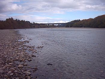
The Hutt River looking downstream
|
|
| Native name | Te Awa Kairangi |
| Other name(s) | Te Wai o Orutu |
| Country | New Zealand |
| Physical characteristics | |
| Main source | Tararua Ranges |
| River mouth | Wellington Harbour 0 m (0 ft) |
| Length | 56 km (35 mi) |
| Basin features | |
| Basin size | 655 km2 (253 sq mi) |
The Te Awa Kairangi / Hutt River is a river in the southern North Island of New Zealand. Its Māori names include Te Awa Kairangi, Te Awakairangi, Te Wai o Orutu, and Heretaunga. The river starts in the Tararua Range and flows south-west for about 56 kilometres (35 mi). Along its path, it creates rich, flat areas called floodplains. These include places like Kaitoke, central Upper Hutt, and Lower Hutt.
Contents
Journey of the Hutt River
The Hutt River begins high up in the Tararua Range. Its very first streams, called headwaters, are in the Kaitoke Regional Park. This area is kept closed to protect the drinking water supply for the wider Wellington region.
Below Kaitoke, the river flows through a narrow valley known as the Kaitoke Gorge. This gorge is a popular spot for rafting. Further downstream, near Te Mārua, another river called the Mangaroa River joins the Hutt from the east. Even further down, at Birchville, the Akatarawa River flows into the Hutt from the west.
The river then moves through a deep channel between hills. It crosses the Wellington Fault, which is a major crack in the Earth's crust. You can see how the land has moved over time by looking at the river terraces in Harcourt Park.
At the start of the Upper Hutt floodplain, the river turns sharply against a cliff at Maoribank. It then flows down the valley, which is where most of Upper Hutt city is located. The Whakatiki River joins the Hutt from the west. From this point, the river follows the straight line of the Wellington geologic fault along the western side of the valley.
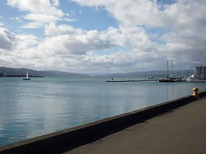
The Taita Gorge separates Upper Hutt from Lower Hutt. This gorge is much shorter than the Kaitoke Gorge. Finally, the river reaches its end at Petone, flowing into Wellington Harbour. The same geological fault that the river followed continues as a steep cliff along the edge of the harbour.
State Highway 2 runs alongside the river for most of its journey. It only leaves the river's side when it goes through the Kaitoke Gorge and near the river's source. After that, the highway crosses the Remutaka Range into the Wairarapa region.
Bridges Crossing the River
Many bridges cross the Hutt River, connecting communities and allowing travel. Here are some of them, listed from upstream to downstream:
- Kaitoke Swingbridges: Two footbridges in Kaitoke Regional Park.
- Akatarawa Road Bridge: A two-lane road bridge opened in 1981. It replaced an older single-lane bridge.
- Norbert Street Footbridge: A footbridge connecting California Park and Harcourt Park.
- Totara Park Bridge: A two-lane road bridge, opened around 1970, that helps people get to the suburb of Totara Park.
- Moonshine Bridge: A curved two-lane road bridge opened in 1987. It's part of the River Road bypass around Upper Hutt.
- Silverstream Road Bridge: A two-lane road bridge that also carries a large water pipe.
- Silverstream Rail Bridge: A double-track rail bridge opened in 1954.
- Pomare Rail Bridge: Another double-track rail bridge, opened in 1954.
- Kennedy-Good Bridge: A two-lane road bridge opened in 1979. It was the first bridge at this spot and is named after a former mayor of Lower Hutt.
- Melling Bridge: A three-lane bridge opened in 1957. It's the second bridge at this location.
- Ewen Bridge: This large arch bridge has four traffic lanes and walkways. It was opened in 1996 and is the seventh bridge built at this site.
- The 'Rail Bridge: A two-track rail bridge with a walkway for pedestrians. It opened in 1927.
- Estuary Bridge: A two-lane road bridge opened in 1954. It also carries a water supply pipe.
River Features and Fun Activities
For most of its length, the Hutt River is quite shallow. It often has a wide, rocky bed where the water splits into several smaller streams, making it a braided river. However, in the Kaitoke Gorge, the river flows directly over solid rock. Closer to its mouth at Petone, the river becomes narrower with steeper banks.
The larger towns of Upper Hutt and Lower Hutt are protected from floods. This is done using stopbanks (raised banks) and planted willow trees. Flooding used to happen regularly in Lower Hutt. This made the land very fertile. Before the government started building state housing there in 1937, Lower Hutt had many market gardens.
The river's path has changed a lot since European settlers arrived. A big earthquake in 1855 actually raised the riverbed.
You can explore the river by walking or cycling along tracks on both sides. The track on the eastern bank is easier to access. The Lower Hutt edition of Parkrun, a weekly 5-kilometre (3.1 mi) running event, takes place along the last 2.5-kilometre (1.6 mi) of the Hutt River. It runs from just north of the Ewen Bridge down to the Waione Bridge and back.
How the River Got Its Name
Since 2011, the river's official name has been Te Awa Kairangi / Hutt River. The first Māori people who lived here, like Ngāi Tara, called it Te Awa Kairangi. Later Māori settlers named it Te Wai o Orutu, after an ancestor named Orutu from the Ngāti Mamoe tribe. By the time European settlers arrived, Māori called it Heretaunga. This name is now used for an Upper Hutt suburb and a secondary school.
The name Hutt was given to the river after Sir William Hutt. He was the chairman of the New Zealand Company, which helped bring settlers to New Zealand. Captain Edward Main Chaffers and Colonel William Wakefield gave the river this name in 1839 while they were mapping Port Nicholson.
River Life
The Hutt River is home to a good number of brown trout, which are a type of fish.
See also
 In Spanish: Río Hutt para niños
 | Emma Amos |
 | Edward Mitchell Bannister |
 | Larry D. Alexander |
 | Ernie Barnes |


