
Nautical chart facts for kids

A nautical chart is a special kind of map that helps people travel safely on the water. It shows you important things like the depth of the ocean, where land is, and where dangers like rocks or shallow areas might be. Sailors, boaters, and even large ships use these charts to navigate and find their way from one place to another.
Contents
What is a Nautical Chart?
A nautical chart is like a detailed picture of a part of the sea. It's made for people who are on boats or ships. These charts show you:
- The shape of the coastline and any islands.
- How deep the water is in different places.
- Where lighthouses, buoys, and other navigation aids are.
- Any dangers, like hidden rocks, shipwrecks, or areas where the water is very shallow.
- Information about tides and currents.
Why are Charts Important for Sailors?
Imagine trying to drive a car without a road map! It would be very hard to know where you're going or what dangers are ahead. Nautical charts do the same job for sailors. They help them:
- Plan their journey safely.
- Avoid running aground (hitting the bottom).
- Stay away from dangerous areas.
- Find the best routes to their destination.
- Know where they are at all times.
History of Nautical Charts
People have been using charts to navigate the seas for a very long time.
Early Sea Maps
The first nautical charts were created many centuries ago. From the 14th century to the 17th century, these charts became very common. They were often drawn by hand and were very valuable. These early charts helped explorers and traders sail across oceans to new lands.
How Charts Changed Over Time
Over the years, nautical charts became much more accurate. New tools and methods were developed to measure depths and positions more precisely. Today, many sailors use electronic charts on computers or special devices. These digital charts can even show a boat's exact position using GPS. However, paper charts are still important as a backup and for learning.
Types of Nautical Charts
There are different kinds of nautical charts, each designed for a specific purpose.
Paper Charts
These are the traditional charts printed on large sheets of paper. They are still used by many sailors. Paper charts are great because you can write notes on them and they don't need electricity.
Electronic Charts
Electronic charts are digital versions of paper charts. They are displayed on computer screens or special navigation devices. These charts can be updated easily and often show your boat's position in real-time. They are very popular because they are convenient and offer many features.
How Electronic Charts Work
Electronic charts use GPS (Global Positioning System) to show exactly where your boat is on the map. They can also connect to other tools on a boat, like radar, to give sailors even more information about their surroundings.
Understanding Chart Symbols
Nautical charts use many special symbols and colors to show different things. For example:
- Numbers show the depth of the water.
- Different colors might show shallow water or land.
- Symbols show where buoys, lighthouses, or dangerous rocks are located.
- Arrows can show the direction of currents.
Learning these symbols is like learning a secret language that helps you understand the ocean!
Images for kids
-
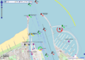
A nautical chart of the Warnemünde harbor shown on OpenSeaMap
-
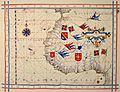
A pre-Mercator nautical chart from 1571, by Portuguese cartographer Fernão Vaz Dourado. It shows how early charts looked, treating the Earth as a flat surface.
-
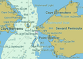
Part of an electronic chart of the Bering Strait
-
An automatically labeled nautical chart
-
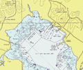
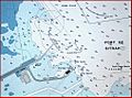
A close-up of a United States NOAA chart, showing a harbor area


See also
 In Spanish: Carta náutica para niños
