
Tasman Peninsula facts for kids
The Tasman Peninsula is a beautiful area in Tasmania, Australia. It's about 75 km south-east of Hobart, the capital city. This special place is known for its amazing natural beauty, interesting history, and efforts to protect the Tasmanian devil.

Contents
Where is the Tasman Peninsula?
The Tasman Peninsula is located south and west of another area called Forestier Peninsula. A very narrow strip of land, known as an isthmus, connects them. This special strip is called Eaglehawk Neck.
The Forestier Peninsula is also connected to the rest of Tasmania by an isthmus called East Bay Neck. This is near the town of Dunalley, which is about 60 km from Hobart.
Visitors to the Tasman Peninsula can explore many interesting places. These include a Conservation Park at Taranna, the famous Port Arthur Historic Site, and several lovely beaches.
A Look at Early History
First People and European Arrival
The first people to live on the Tasman Peninsula were the Australian Aboriginal people. They were part of a larger group called the Oyster Bay tribe. This tribe lived along the east coast of Tasmania. The peninsula itself is named after Dutch explorer Abel Tasman.
The first European settlement in this area began in the 1830s at Port Arthur. It was chosen to be a penal colony (a prison settlement) because it was very isolated from the rest of Tasmania. It was also easy to reach by sea. Another prison colony, at Macquarie Harbour on the west coast, was much harder to get to. Because of this, prisoners from Macquarie Harbour were moved to the new prison at Port Arthur.
Why Port Arthur Was Chosen
The Tasman Peninsula had many trees, which were perfect for building ships and houses. It also had a deep, safe harbour where visiting British warships could be repaired. To stop prisoners from escaping, Eaglehawk Neck was guarded by soldiers and guard dogs. Even with these measures, some convicts did escape, including a famous bushranger named Martin Cash.
The Saltwater River, Tasmania historic site is located near the north-west tip of the peninsula. This place was originally a coal mine. Prisoners worked digging for coal during the day. At night, they lived in underground cells.
Port Arthur Today
Today, the old prison at Port Arthur is a popular tourist attraction. Tourism is a big business in many parts of Tasmania. Many people also enjoy bushwalking in the wilder parts of the peninsula. Popular walking spots include Cape Raoul and Cape Pillar. These capes are at the south-west and south-east ends of the peninsula, on either side of the entrance to Port Arthur.
Saving the Tasmanian Devil
The Tasman Peninsula is now a very important place in the fight to save the Tasmanian Devil. These unique animals have been getting a new type of cancer called Devil Facial Tumour Disease (DFTD). This disease has spread quickly and has already killed more than half of the Tasmanian devils.
The peninsula's isolation from the rest of Tasmania makes it a perfect place to keep a healthy group of wild Tasmanian devils safe. This important project involves the local Tasmanian Devil Conservation Park at Taranna. It also includes government and university scientists working together.
The Amazing Coastline
The Tasman Peninsula has a very rocky coastline. Because of this, it has been the site of several shipwrecks over the years. For example, two large steamships, the Tasman (in 1883) and the Nord (in 1915), sank after hitting the Hyppolyte Rocks off the east coast. Munroe Bight, north of Cape Pillar, is named after an American ship called the James Munroe, which was wrecked there in 1850.
Local Life and Industry
Between the time of the convict settlement and the start of the modern tourist industry, most people on the Tasman Peninsula worked in the timber industry and fishing. The land was not very good for large farms. However, there are still some fruit orchards and small mixed farms today.
The area was quite isolated until a regular river steamer started sailing from Port Arthur to Hobart in the 1880s. From 1900 to the 1930s, the main shipping company was the Huon, Channel & Peninsula Steamship Company. They owned several ships, including the M.V. Cartela.
Towns and Government
Many smaller towns are also located on the Tasman Peninsula. The largest towns are Nubeena and Koonya. Smaller villages include Premaydena, Highcroft, and Stormlea.
The local government for the area is the Tasman Council. The main road that connects the peninsula to Hobart is called the Arthur Highway. About 2000 people live on the Tasman Peninsula permanently. However, in summer, many visitors come, and the population can grow to around 6000 people.
Natural Wonders and Activities
The Tasman Peninsula is famous for its stunning rocky eastern coastline. Much of this beautiful area is now part of the Tasman National Park. At Eaglehawk Neck, the rocks have been shaped by nature into many strange and wonderful forms. These include the Remarkable Caves, Tasman's Arch, and the Tessellated Pavement.
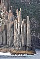
On the south side of the peninsula, you can find some of the highest sea cliffs in the southern hemisphere. These cliffs rise an amazing 300 meters above the Tasman Sea at Cape Hauy. The peninsula is also known as one of Australia's best surfing spots, especially at Cape Raoul and Roaring Beach.
Images for kids
-
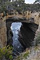
Tasman arch and littoral chasm, Tasman National Park.
-
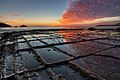
Tessellated pavement natural rock formation
-
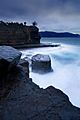
Fossil Bay at sunset.
-
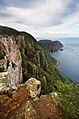
Dolerite columns of Cape Raoul.
-
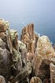
Columns at the tip of the cape.
-
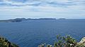
Tasman Island and Tasman Peninsula from Cape Raoul.
-
Tip of the cape from the sea.


See also
 In Spanish: Península de Tasman para niños
