Koonya, Tasmania facts for kids
Quick facts for kids KoonyaTasmania |
|||||||||||||||
|---|---|---|---|---|---|---|---|---|---|---|---|---|---|---|---|

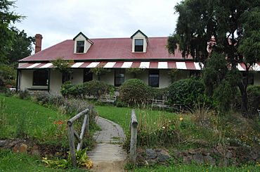
Officers quarters for the penal colony
|
|||||||||||||||
| Population | 134 (2016 census) | ||||||||||||||
| Postcode(s) | 7184 | ||||||||||||||
| Location | 18 km (11 mi) NE of Nubeena | ||||||||||||||
| LGA(s) | Tasman | ||||||||||||||
| Region | South-east | ||||||||||||||
| State electorate(s) | Lyons | ||||||||||||||
| Federal Division(s) | Lyons | ||||||||||||||
|
|||||||||||||||
Koonya is a small rural area located in Tasmania, Australia. It's part of the Tasman Council region in the south-east of the state. Koonya is about 18 kilometers (11 miles) northeast of the town of Nubeena. In 2016, a census showed that 134 people lived in Koonya. Each year, Koonya hosts a special event called the Koonya Garlic Festival, which is a fun one-day celebration.
Contents
Koonya's Past: From Convicts to Community
The area we now call Koonya was once known as Cascades. Its name changed to Koonya by the year 1888. Koonya was officially recognized as a locality in 1968. People believe the name "Koonya" comes from an Aboriginal word, but its exact meaning is still debated.
Koonya was first set up in 1841. It was one of the many smaller sites that were part of the large Port Arthur penal colony network. A penal colony was a place where prisoners were sent to live and work.
Life as Cascades: A Convict Settlement
When it was known as "Cascades," this area was home to at least 400 convicts. These were people who had been sent from Britain to serve their sentences in Australia.
After the Port Arthur penal colony closed down, the land known as Van Diemen's Land was renamed "Tasmania." At this time, many places in Tasmania were given new names. That's when "Cascades" officially became "Koonya."
Where is Koonya? Its Location and Features
Koonya is located right next to the beautiful waters of Norfolk Bay. This bay forms most of Koonya's northern border.
Keeping an Eye on the Weather
An important weather radar is located in Koonya. This radar helps the City of Hobart and surrounding areas by tracking weather patterns. It provides important information for weather forecasts.
Getting Around: Roads in Koonya
Koonya has a few main roads that help people travel through the area. Route B37, also known as Nubeena Road, enters Koonya from the northeast. It then runs through the area towards the northwest before leaving.
Another road, Route C343 (Nubeena Back Road), starts at an intersection with Route B37. This road then travels southwest until it leaves the Koonya area.
 | Emma Amos |
 | Edward Mitchell Bannister |
 | Larry D. Alexander |
 | Ernie Barnes |


