
Cape Raoul facts for kids
Quick facts for kids Cape RaoulTasmania |
|||||||||||||||
|---|---|---|---|---|---|---|---|---|---|---|---|---|---|---|---|

Cape Raoul
Location in Tasmania
|
|||||||||||||||
| Population | nil (2016) | ||||||||||||||
| Postcode(s) | 7184 | ||||||||||||||
| Location | 13 km (8 mi) S of Nubeena | ||||||||||||||
| LGA(s) | Tasman | ||||||||||||||
| Region | South-east | ||||||||||||||
| State electorate(s) | Lyons | ||||||||||||||
| Federal Division(s) | Lyons | ||||||||||||||
|
|||||||||||||||
Cape Raoul is an amazing natural landmark and a quiet rural area in Tasmania, Australia. It's part of the Tasman region in the south-east of the state. You can find it about 13 kilometers (8 miles) south of the town of Nubeena. In 2016, a census showed that no one lives permanently at Cape Raoul, making it a truly wild and natural spot!
Contents
Discovering Cape Raoul's Location
Cape Raoul is a special place located at the very southern tip of the Tasman Peninsula. It forms part of the stunning coastline of Raoul Bay. This whole area is also part of the larger Tasman National Park.
The western, southern, and eastern edges of Cape Raoul are bordered by the vast Tasman Sea. This means you're surrounded by ocean on three sides! The cape itself is made of a type of rock called dolerite, which gives it a unique and rugged look.

Exploring the Geography of Cape Raoul
Cape Raoul is famous for its incredible rock formations. You'll see huge cliffs, flat rock platforms, and tall, pillar-like columns rising from the sea. There's even a cliff that's about 300 meters (980 feet) high, offering amazing views of the coastline.
If you love hiking, there's a 7-kilometer (4.3-mile) walking track that leads to the Cape Raoul plateau. At the end of this plateau, you'll find the most spectacular part: towering columns made of dolerite rock. It's a truly breathtaking sight!
You can get to Cape Raoul by driving through Port Arthur and then along Stormlea Road.
The Mystery of the Columns
The giant rock columns at Cape Raoul look like they were carefully placed there, almost like a grand hallway! These columns are formed by something called columnar jointing.
This amazing process happens when a large amount of hot, melted rock (magma) cools down very slowly. As the surface of the magma cools, it shrinks and cracks. These cracks then spread downwards, creating many-sided shapes, like hexagons. As the cooling continues, these cracks extend deeper, forming the tall, distinct columns you see today. It's nature's own incredible sculpture!
A Glimpse into History
Cape Raoul has an interesting history regarding its name. In 1911, a note described how the cape got its name:
It was named after D'Entrecasteaux's pilot, whose last name was Raoul. Another explorer, Flinders, first called it "Basaltic Cape." However, after seeing the maps from the French expedition, Flinders decided to change the name back to Raoul. Even with this, some maps later still showed it as "Raoul or Basaltic." It's cool how names of places can change over time!
Gallery
-
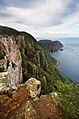
Dolerite columns of Cape Raoul.
-
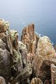
Columns at the tip of the cape.
-
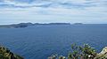
Tasman Island and Tasman Peninsula from Cape Raoul.


