
Eaglehawk Neck facts for kids
Quick facts for kids Teralina / Eaglehawk Neck |
|
|---|---|
| Eaglehawk Neck | |

Eaglehawk Neck from Martin Cash's lookout.
|
|

Location in Tasmania
|
|
| Location | Forestier Peninsula and Tasman Peninsula in south-eastern Tasmania, Australia |
| Coordinates | 43°00′36″S 147°55′12″E / 43.01000°S 147.92000°E |
| Length | 400 metres (1,300 ft) |
| Width | 30 metres (98 ft) |
| Geology | Isthmus |
| Designation | |
| LGA | Tasman |
Eaglehawk Neck, also known as Teralina / Eaglehawk Neck, is a very narrow strip of land. It connects the Tasman Peninsula to the Forestier Peninsula. This land bridge then links to the rest of Tasmania, Australia.
This special place is about 26 kilometres (16 mi) north-east of Nubeena. It is part of the Tasman area in south-east Tasmania. In 2016, about 385 people lived there.
Contents
What Makes Eaglehawk Neck Special?
This narrow strip of land is only about 400 metres (1,300 ft) long. At its thinnest point, it's less than 30 metres (98 ft) wide. The area is known for its rough land and cool rock shapes. One famous spot is the Tessellated Pavement. This is a natural rock formation that looks like a tiled floor.
Clyde Island is near the northern part of Pirates Bay. You can walk to it when the tide is low. The island has two graves and a loud blowhole.
Eaglehawk Neck is a popular place for holidays. On the eastern side, there's a beach called Pirates Bay. It's a great spot for surfing. In summer, many people come to stay in their holiday homes.
- Eaglehawk Neck
-
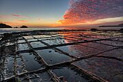
Tessellated Pavement at sunrise -
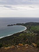
Pirates Bay and Doo Town -
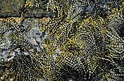
Hormosira growing on the Tesselated pavement at Eaglehawk Neck -
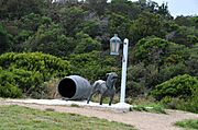
Statue representing the dogline at Eaglehawk Neck


A Look Back: European History
Eaglehawk Neck was officially named a place in 1967. In March 2021, it was given a second name, Teralina. This was to include its original name.
The Famous Dog Line
Eaglehawk Neck was a perfect natural barrier. The British used it to stop people from escaping. These were convicts trying to get away from Port Arthur. Port Arthur was a prison on the Tasman Peninsula.
A special system was set up here. A line of dogs was chained to posts across the "Neck." These dogs would bark and warn guards if any convicts tried to escape. This "Dog Line" started in 1831. It was used until Port Arthur closed in the 1870s.
Thomas J. Lempriere, a prison officer, said Eaglehawk Neck was "impassable." But some convicts still tried to escape. Famous ones include Martin Cash and William Bannon. Soldiers patrolled the area very closely. The old guards' building is now a museum.
Today, the Arthur Highway runs through the isthmus. This road leads to Port Arthur. Port Arthur is part of the Australian Convict Sites. This is a World Heritage Site. It includes eleven old prison sites built by the British. These sites show how European powers expanded using the work of convicts.
Post Office History
The first post office in Eagle Hawk Neck opened in 1875. It closed two years later in 1877. A new post office opened on January 11, 1895. It served the area until 1974.
Where is Eaglehawk Neck?
The western side of Eaglehawk Neck is next to Norfolk Bay. The eastern side faces the Tasman Sea.
Getting Around: Roads
The main road, the A9 route (Arthur Highway), comes from the north. It goes through the center and then leaves to the south-west. Another road, Route C338 (Blowhole Road / Tasmans Arch Road), starts in the middle. It goes south-east and ends at Tasman Arch.
