Brouwer Route facts for kids
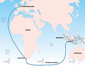
The Brouwer Route was a very important sea route used by ships in the 1600s. It helped ships travel much faster from the Cape of Good Hope (at the southern tip of Africa) to the Dutch East Indies (modern-day Indonesia). This route was part of a bigger journey called the Cape Route.

The route worked by taking ships south from the Cape into an area known as the Roaring Forties. This area has very strong westerly winds. Ships would then sail east across the Indian Ocean, using these powerful winds to speed up their journey. Finally, they would turn northeast towards Java.
Contents
Why the Brouwer Route Was Important
The Brouwer Route was created by the Dutch explorer Hendrik Brouwer in 1611. Before this, ships often followed the coast of East Africa. They would sail through the Mozambique Channel around Madagascar and then across the Indian Ocean. This old way was much slower.
Brouwer's new route cut the travel time from Europe to Java in half! This was a huge improvement for trade. By 1616, the Dutch East India Company made it a rule that all their ship captains had to use the Brouwer Route.
Challenges of the Route
Even though the route was faster, it had a big problem. In the 1600s, sailors didn't have accurate ways to figure out their exact longitude. This meant they didn't know how far east they had traveled.
The only way for captains to know when to turn north was by spotting Amsterdam Island or Saint Paul Island. But this depended on the captain's skill. If they missed these islands or misjudged their position, they could sail too far east.
Because of this, many ships were damaged or wrecked. They crashed into rocks, reefs, or islands along the western coast of Australia. At that time, Europeans knew very little about Australia's coast.
Early English Attempts
The British East India Company also tried to use this faster route. In 1620, Captain Humphrey Fitzherbert used it with his ship, Royal Exchange. They called it the Southern route and thought it was a big success.
However, the second English ship to try the route, Tryall, made a mistake. It sailed too far east before turning north. In May 1622, the ship was wrecked on Tryal Rocks off the Pilbara coast of Australia. After this accident, the English avoided the route for about 20 years.
Discovering Australia's Coast
The Brouwer Route played a major role in Europeans discovering the west coast of Australia. Sadly, many ships were wrecked along this coast. Some famous shipwrecks include:
- Batavia in 1629
- Vergulde Draeck in 1656
- Zuytdorp in 1712
- Zeewijk in 1727
In 1696, Willem de Vlamingh explored the Australian coast. He was looking for survivors of the Ridderschap van Holland, which had disappeared in 1694 with about 300 people on board. Neither the ship nor any survivors were ever found.
See also
 In Spanish: Ruta de Brouwer para niños
- Clipper route
Readings
 | Claudette Colvin |
 | Myrlie Evers-Williams |
 | Alberta Odell Jones |

