
Pilbara facts for kids
Quick facts for kids Pilbara |
|
| Region | |
 The Pilbara region according to the Regional Development Commissions Act 1993
|
|
| Country | Australia |
|---|---|
| State | Western Australia |
| Area | 502,000 km² (193,823 sq mi) |
| Population | 48,610 (2010) |


_Melbourne_Museum.jpg)
The Pilbara is a very large, dry area in the north of Western Australia. It has a small population. This region is famous for its Aboriginal people, ancient landscapes, and red earth. It also has huge amounts of minerals, especially iron ore. The Pilbara is also a special place for tiny underground animals. It is one of nine official regions in Western Australia.
The Pilbara covers about 502,000 square kilometers. This area holds some of Earth's oldest rocks. The landscape includes flat coastal areas and mountain ranges with tall cliffs and deep gorges. The main towns are Port Hedland, Karratha, and Newman.
This region is important for Australia's economy. It has large deposits of petroleum, natural gas, and iron ore. Besides mining, people also work in farming, fishing, and tourism.
Contents
What's in a Name?
The Pilbara Aboriginal Language Centre says the name comes from bilybara. This Aboriginal word means 'dry' in the Nyamal and Banyjima languages.
Another idea is that the name comes from pilbarra. This is an Aboriginal word for the mullet (fish). Pilbara Creek, which flows into the Yule River, was first called "Pilbarra". This creek gave its name to the Pilbara Goldfield, found in 1885. After that, the name was used for the whole region.
Pilbara's Past

The first European to explore this area was Francis Thomas Gregory in 1861. Later, towns like Cossack and Roebourne were built along the coast. These towns were centers for farming. However, they became less important after 1900.
Mining started in 1937 in Wittenoom Gorge. In the 1960s, a lot of iron ore was found in the Hamersley Ranges. This made the Pilbara very important for Western Australia's economy. New towns grew quickly to support the mining industry. On October 3, 1952, the British tested their first atomic bomb here. This happened on the Montebello Islands as part of Operation Hurricane.
Aboriginal People of Pilbara

Aboriginal people have lived in the Pilbara for 30,000 to 40,000 years. They were here long before Europeans arrived. Evidence shows people lived here even during the last Ice Age. Their early history is told through stories, old sites, and rock carvings.
Near the town of Dampier is a place called Murujuga. It has a huge collection of petroglyphs (rock carvings). These carvings are thousands of years old and are a World Heritage site. In the Pilbara, rock art is mostly carved into hard rock. In other areas, like the Kimberley, it's often painted on softer rock.
Around 1900, working conditions for Aboriginal people in the pearling and farming industries were very unfair. People were often not paid. They could be taken against their will and punished harshly. In 1946, Aboriginal farm workers in the Pilbara went on strike. This was the first strike by Indigenous people in Australia. They protested low pay and bad conditions. The strike lasted for over three years.
Some Aboriginal families, with help from a mining prospector, learned mining skills. They earned money, which they wanted to use for traditional ways of life. Eventually, this money helped start an independent Aboriginal-run school. This idea grew, and by the mid-1990s, about 20 similar schools were set up in northern Western Australia.
Many Aboriginal communities in the Pilbara face challenges. These include issues with housing, health, and education.
Where is Pilbara?


The Pilbara region is south of the Kimberley. It includes the local areas of Ashburton, East Pilbara, Karratha, and Port Hedland.
The Pilbara covers about 507,896 square kilometers. This is roughly the size of the US states of California and Indiana combined. It has over 45,000 people. Most of them live in the western part of the region. Towns there include Port Hedland, Karratha, Wickham, Newman, and Marble Bar. Many people also work here by flying in and out.
The Pilbara has three main geographic areas:
- The western part is a sandy coastal plain. Most people and industries are here.
- The eastern part is mostly desert. Only a few Aboriginal people live here.
- In between are the inland uplands. These include the Hamersley Range and Chichester Range. These areas have many mining towns, gorges, and natural sights.
The Pilbara has some of the world's oldest rocks. These include stromatolites, which are ancient fossilized remains. Some rocks like granite are over three billion years old. In 2007, scientists found signs of life in 3.4-billion-year-old sandstones near Strelley Pool. These fossils show tiny bacteria that used sulfur for energy.
Pilbara's Weather

The Pilbara has a very dry and tropical climate. It gets very hot, and rainfall is low and irregular. Most rain comes during summer cyclones. In summer, temperatures are usually above 32 °C (90 °F) every day. Temperatures over 45 °C (113 °F) are common.
In winter, coastal temperatures rarely drop below 10 °C (50 °F). However, inland areas can sometimes get as cold as 0 °C (32 °F). The town of Marble Bar holds a world record. It had 160 days in a row with temperatures of 37.8 °C (100.0 °F) or higher. This happened from October 1923 to April 1924.
The region gets between 200 and 350 millimetres (7.9 and 13.8 in) of rain each year. Almost all of it falls from December to May. This usually happens in heavy thunderstorms or tropical cyclones. From June to November, it is usually very dry, hot, and sunny. Tropical cyclones sometimes hit the coastal areas. About 7 cyclones cross the Pilbara coast every 10 years. Because few people live here, cyclones rarely cause major damage or loss of life.
| Climate data for Port Hedland (Coastal) | |||||||||||||
|---|---|---|---|---|---|---|---|---|---|---|---|---|---|
| Month | Jan | Feb | Mar | Apr | May | Jun | Jul | Aug | Sep | Oct | Nov | Dec | Year |
| Record high °C (°F) | 49.0 (120.2) |
48.2 (118.8) |
45.9 (114.6) |
42.4 (108.3) |
38.8 (101.8) |
35.5 (95.9) |
34.4 (93.9) |
36.8 (98.2) |
42.2 (108.0) |
46.9 (116.4) |
47.4 (117.3) |
47.9 (118.2) |
49.0 (120.2) |
| Mean daily maximum °C (°F) | 36.4 (97.5) |
36.2 (97.2) |
36.7 (98.1) |
35.2 (95.4) |
30.6 (87.1) |
27.6 (81.7) |
27.1 (80.8) |
29.2 (84.6) |
32.3 (90.1) |
34.8 (94.6) |
36.2 (97.2) |
36.6 (97.9) |
33.2 (91.8) |
| Mean daily minimum °C (°F) | 25.6 (78.1) |
25.5 (77.9) |
24.5 (76.1) |
21.4 (70.5) |
17.2 (63.0) |
14.1 (57.4) |
12.3 (54.1) |
13.1 (55.6) |
15.4 (59.7) |
18.4 (65.1) |
21.3 (70.3) |
24.0 (75.2) |
19.4 (66.9) |
| Record low °C (°F) | 18.1 (64.6) |
16.3 (61.3) |
15.8 (60.4) |
12.2 (54.0) |
7.0 (44.6) |
4.7 (40.5) |
3.2 (37.8) |
3.7 (38.7) |
7.7 (45.9) |
11.1 (52.0) |
12.4 (54.3) |
16.6 (61.9) |
3.2 (37.8) |
| Average rainfall mm (inches) | 62.2 (2.45) |
94.8 (3.73) |
50.1 (1.97) |
22.4 (0.88) |
27.0 (1.06) |
20.7 (0.81) |
11.1 (0.44) |
4.9 (0.19) |
1.3 (0.05) |
0.9 (0.04) |
2.7 (0.11) |
17.9 (0.70) |
314.4 (12.38) |
| Source: Bureau of Meteorology | |||||||||||||
| Climate data for Newman (Inland) | |||||||||||||
|---|---|---|---|---|---|---|---|---|---|---|---|---|---|
| Month | Jan | Feb | Mar | Apr | May | Jun | Jul | Aug | Sep | Oct | Nov | Dec | Year |
| Record high °C (°F) | 47.0 (116.6) |
46.0 (114.8) |
43.3 (109.9) |
40.4 (104.7) |
35.2 (95.4) |
33.0 (91.4) |
31.0 (87.8) |
34.1 (93.4) |
38.0 (100.4) |
42.9 (109.2) |
43.9 (111.0) |
45.0 (113.0) |
47.0 (116.6) |
| Mean daily maximum °C (°F) | 39.5 (103.1) |
37.2 (99.0) |
35.8 (96.4) |
31.6 (88.9) |
27.3 (81.1) |
22.9 (73.2) |
23.0 (73.4) |
25.8 (78.4) |
30.5 (86.9) |
35.0 (95.0) |
37.4 (99.3) |
38.9 (102.0) |
32.1 (89.8) |
| Mean daily minimum °C (°F) | 25.3 (77.5) |
24.4 (75.9) |
22.4 (72.3) |
18.4 (65.1) |
13.0 (55.4) |
9.6 (49.3) |
8.1 (46.6) |
10.1 (50.2) |
13.7 (56.7) |
17.9 (64.2) |
21.4 (70.5) |
23.9 (75.0) |
17.3 (63.1) |
| Record low °C (°F) | 16.1 (61.0) |
17.0 (62.6) |
9.0 (48.2) |
6.0 (42.8) |
1.0 (33.8) |
−1.1 (30.0) |
−2.0 (28.4) |
−2.0 (28.4) |
1.0 (33.8) |
6.0 (42.8) |
11.8 (53.2) |
15.2 (59.4) |
−2.0 (28.4) |
| Average precipitation mm (inches) | 57.2 (2.25) |
78.9 (3.11) |
41.7 (1.64) |
18.4 (0.72) |
18.5 (0.73) |
14.6 (0.57) |
15.1 (0.59) |
7.7 (0.30) |
3.4 (0.13) |
4.7 (0.19) |
10.5 (0.41) |
37.4 (1.47) |
312.0 (12.28) |
Plants and Animals

The main plants in the Pilbara are acacia trees and shrubs. There are also tough spinifex grasses that can handle dry weather. Many acacia species grow only in the Pilbara. Efforts are made to protect these plants, along with local wildflowers.
The Pilbara is home to many unique animals. These animals have adapted to this harsh environment. There are hundreds of types of tiny invertebrates that live underground. These include stygofauna (in water) and troglofauna (in caves).
Some special animals found here are:
- The Pilbara olive python
- The western pebble-mound mouse
- The Pilbara ningaui (a small marsupial)
Birds like the Australian hobby, nankeen kestrel, and budgerigars also live here.
Mining for iron, natural gas, and asbestos has affected wildlife. However, several protected areas now help keep the Pilbara's nature safe. These include the Millstream-Chichester and Karijini National Parks.
Pilbara's Economy
The Pilbara's economy mainly relies on mining and petroleum exports.
Iron Ore Mining


Most of Australia's iron ore comes from the Pilbara. Mines are mostly around Tom Price and Newman. The iron ore industry employs 9,000 people from the Pilbara. The region also has a major manganese mine called Woodie Woodie.
Iron ore was first found in 1957 by Stan Hilditch. He discovered a large deposit at what became the Mount Whaleback mine. In the 1960s, it was called "one of the most massive ore bodies in the world."
Australia has about 24 billion tonnes of iron ore that can be mined. In 2010, about 324 million tonnes were being used each year. Experts believe this resource could last for another 30 to 50 years.
Some active iron ore mines in the Pilbara include:
- BHP mines: Area C mine, Jimblebar mine, Mount Whaleback mine, Yandi mine
- Fortescue Metals Group mines: Christmas Creek mine, Cloud Break mine
- Rio Tinto mines: Brockman mine, Hope Downs mine, Mount Tom Price mine, Paraburdoo mine
- Other mines: BC Iron, Atlas Iron, Moly Mines
Natural Gas
A big part of the Pilbara's economy comes from liquified natural gas (LNG). This is produced at the North West Shelf Venture and Pluto LNG plant.
Other Industries

The region also has many cattle farms. Tourism is also important, with popular places like Karijini and Millstream-Chichester national parks. The Dampier Archipelago is another popular spot.
Transportation

The first railway in the Pilbara was the narrow-gauge Marble Bar Railway. It ran between Port Hedland and Marble Bar. It opened in 1911 and closed in 1951. Many other railways have been built to serve the mines.
Today, there are four heavy-duty railways for iron ore. A fifth line is planned for the Fortescue Metals Group mines. These railways are built to very strong standards. Between 2008 and 2012, Rio Tinto planned to use driverless trains on its railways. Another 300 km line is planned from the Roy Hill mine to a port near Port Hedland.
Ports
The main ports in the Pilbara are:
- Port Hedland
- Nelson Point and Finucane Island (run by BHP)
- Herb Elliott Port (run by Fortescue Metals Group)
- Dampier (run by Rio Tinto)
- Cape Lambert (run by Rio Tinto)
- Anketell Port (still being built)
Images for kids
-
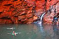
Weano Gorge in Karijini National Park

See also
 In Spanish: Pilbara para niños
