
Roebourne, Western Australia facts for kids
Quick facts for kids RoebourneWestern Australia |
|||||||||
|---|---|---|---|---|---|---|---|---|---|

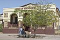
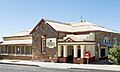
Roebourne Tourist Centre (formerly the entrance to Roebourne Gaol)
|
|||||||||

Roebourne
Location in Western Australia
|
|||||||||
| Established | Proclaimed a township on 17 August 1866 | ||||||||
| Postcode(s) | 6718 | ||||||||
| Elevation | 12 m (39 ft) | ||||||||
| Area | [convert: needs a number] | ||||||||
| Location |
|
||||||||
| LGA(s) | City of Karratha | ||||||||
| State electorate(s) | North West | ||||||||
| Federal Division(s) | Durack | ||||||||
|
|||||||||
Roebourne (pronounced ROH-bern), also known by its Ngarluma name Ieramugadu (or Yirramagardu), is a town in Western Australia's Pilbara region. It is about 35 km from Karratha. It is also 202 km from Port Hedland. The state capital, Perth, is 1,563 km away. Roebourne is the only town on the North West Coastal Highway for over 2,000 km. It is part of the City of Karratha.
Roebourne grew quickly during the gold boom in the late 1800s. It was once the biggest town between Darwin and Perth. In 2016, Roebourne and its nearby areas had a population of 981 people.
Contents
History of Roebourne
Roebourne is on the traditional lands of the Ngarluma people. They have lived here for tens of thousands of years. Many Ngarluma people still live in Roebourne today. They continue to practice their traditional laws, culture, and language. The Ngarluma and Yindjibarndi people work together through the Ngarluma and Yindjibarndi Foundation Ltd. The Ngarluma people have native title rights for the Roebourne area.
What does Ieramugadu mean?
The name Ieramugadu (or Yirramagardu) is used by local Aboriginal people. It is a Ngarluma word for a type of native fig tree. These fig trees grow in and around the area. The fruit from these trees is a food source for the traditional owners. Old evidence shows that people have lived in this area for over 40,000 years.
How Roebourne got its name
Roebourne is named after John Septimus Roe. He was the first Surveyor General of Western Australia.
Early European settlement
Francis Thomas Gregory explored the Pilbara region in 1861. He landed near where Roebourne is now. He traveled inland about 60 km. Gregory thought the area was good for farming and raising animals.
The first British settlers arrived in 1863. This included Emma Withnell and her family. They settled near the Harding River. This was about 13 km from the coast. They had access to fresh water there. They also took up 30,000 acre of land. Like many settlers, they hired local Aboriginal people to work. These workers helped as shepherds, laborers, and shearers.
By 1865, about 200 people lived in the area. The Withnell family's property became a local center. John Withnell opened a store. He also provided cart services to other settlers. Before a church was built, church services were held in their home.
Becoming a town
In November 1865, Robert John Sholl arrived. He was a government official. He helped develop the region. He set up camp near the Withnells' home. He was looking for a good spot for a town. He decided to put the town where his camp was.
On August 17, 1866, Roebourne became the first official town in the North West. A surveyor named Charles Wedge drew a plan for 106 land lots. Roebourne became the main administrative center for the region. Government buildings, shops, and hotels were built. Sholl was a justice of the peace and a magistrate. He cared about the local Aboriginal people. He asked the government to make sure they had basic rights.
Important buildings and events
In 1872, a cyclone destroyed the town. Many buildings built after this time are now considered historic. Some of these buildings were designed by George Temple-Poole. He was a famous architect for the Public Works Department.
The Old Roebourne Gaol (jail) started being built in 1896. Aboriginal prisoners quarried and laid the stones. They were held there in very tough conditions. The jail was used from 1896 to 1923. It was used again from 1975 to 1984. A new Roebourne Regional Prison opened later. This new prison is still debated. Temperatures can reach 50 °C, and cells do not have air-conditioning.
The Withnells' original house was rebuilt in 1937. It is on Hampton Street at the foot of Mount Welcome.
Gold and copper mining
Gold was found in Nullagine in 1878. Nearby copper and tin mines also helped Roebourne grow. This made the town rich in the 1880s and 1890s. When mining slowed down, Roebourne lost most of its European population. It became much smaller than before. Some old buildings from this rich time are still around.
Another cyclone hit the area in 1925. It destroyed the Port Samson jetty. It also lifted a bridge from the river. Several buildings were destroyed. Town residents found safety in public brick buildings during the storm.
Changes in the 20th century
Until the 1960s, Roebourne was mainly a non-Indigenous town. It was a regional center for government. There were strict rules for Aboriginal people. They had limited movement in and out of the town. Most Aboriginal people had to stay in camps or reserves a few kilometers away.
Later, mining companies built new towns. These included Dampier and Wickham. They were built for workers in the iron ore mines. Farming also declined. In the late 1960s, attitudes towards Aboriginal welfare changed. Many Aboriginal people moved from crowded camps and stations into Roebourne. This made Roebourne a town with mostly Aboriginal residents.
Roebourne today
Today, Roebourne serves people traveling on the North West Coastal Highway. It is also a gateway for tourism. Many national parks are in the area.
The Roebourne School (built in 1905) provides education. It is a K-12 school for about 250 Aboriginal students. Roebourne also has a TAFE campus, a library, and a telecentre. There is also a small hospital. Many other services are available in Karratha, which is 40 km away.
The Ngarluma people live in the area. Many Yindjibarndi and Banyjima people from nearby stations also live in Roebourne.
The Ganalili Centre is a cultural space owned by Aboriginal people. It used to be the Victoria Hotel. This hotel was known for a sad event in 1983.
Ngarluma Yindjibarndi Foundation Ltd
The Ngarluma Yindjibarndi Foundation Ltd (NYFL) is the main Traditional Owner organization in Roebourne. It is made up of two First Nations: the Ngarluma people and the Yindjibarndi people. They formed NYFL in 1998. It helps represent traditional owners. Its goal is to create positive social change and self-determination for the Roebourne community.
NYFL is part of an agreement for the land where the Woodside-operated North West Shelf project operates. However, NYFL does not receive money from this agreement.
For many years, NYFL has run the Warrgamugardi Yirdiyabura (WY) Program. This program has won awards. It helps Roebourne Ngarda-ngarli (Aboriginal people) become more independent in their work.
Recent changes and success
In 2018, NYFL faced financial problems. New leaders were appointed. By early 2023, NYFL was in a strong financial position again. The Chamber of Commerce and Industry recognized it as the 'best community organization'. This was a big improvement for an organization that had faced difficulties. The National Indigenous Times reported that NYFL, with elders and community leaders, has transformed Roebourne. It has brought back a sense of pride to the town. This recent success is due to strong leadership from the Traditional Owner board and new executive leaders.
NYFL runs many programs that help the community. These include the Ieramagadu Store Maya. This is a social enterprise café at the Old Roebourne General Store. Local Aboriginal people get training and job skills there. The NYFL Employment and Training program (which includes Warrgamugardi Yirdiyabura) helps people find jobs. It also helps them become more economically independent. The Pilbara News said that community-led support, like NYFL's programs, has been key to Roebourne's changing identity.
In 2022, NYFL helped many people in Roebourne find jobs and training. This was through the NYFL Employment and Training program. The National Indigenous Times says this program is the most successful Aboriginal-run employment program in the West Pilbara. It has a special way of helping Aboriginal people who live in or have strong ties to Roebourne.
NYFL also runs the Ieramugadu Store Maya. This is a not-for-profit "social supermarket." It is located at the Old Roebourne General Store. The store serves Roebourne and nearby communities. These include Cheeditha, Ngurrawaana, Mingullatharndo, and Weymul.
Roebourne in the arts
Ieramugadu is a place for creative projects. Big hART started projects here. From 2011 to 2015, the Yijala Yala project created a successful interactive comic book called Neomad. They also made films, theater shows, and art exhibitions. A new project, called New Roebourne, continues this work. It offers workshops, performances, videos, and music programs. In 2021-22, it ran five project streams. One was NEO-Learning, an education platform for primary schools. Roebourne children created the digital content for it.
The 2020 TV series Thalu was shown on NITV and ABC Me. Local producers Tyson Mowarin and Robyn Marais made it. The series involved a lot of community help. Local children and elders appeared in the show.
Environment and climate
The Harding River flows through Roebourne. It runs to the Indian Ocean at Cossack. The Cossack townsite is managed by the NYFL. The Harding River used to flow much more. This was before the Harding Dam was built. Today, the river has a series of waterholes. Some are in the Roebourne townsite.
The highest temperature ever recorded in Roebourne was 50.5 °C. This happened on January 13, 2022. Roebourne was one of three towns in Western Australia to reach over 50 °C that day.
| Climate data for Roeburne, WA | |||||||||||||
|---|---|---|---|---|---|---|---|---|---|---|---|---|---|
| Month | Jan | Feb | Mar | Apr | May | Jun | Jul | Aug | Sep | Oct | Nov | Dec | Year |
| Record high °C (°F) | 50.5 (122.9) |
49.1 (120.4) |
48.1 (118.6) |
43.4 (110.1) |
39.6 (103.3) |
35.7 (96.3) |
34.8 (94.6) |
37.9 (100.2) |
42.1 (107.8) |
45.9 (114.6) |
47.4 (117.3) |
49.5 (121.1) |
50.5 (122.9) |
| Mean daily maximum °C (°F) | 38.7 (101.7) |
38.0 (100.4) |
37.6 (99.7) |
35.3 (95.5) |
30.4 (86.7) |
27.0 (80.6) |
26.8 (80.2) |
29.0 (84.2) |
32.6 (90.7) |
35.6 (96.1) |
38.0 (100.4) |
39.0 (102.2) |
34.0 (93.2) |
| Mean daily minimum °C (°F) | 26.2 (79.2) |
26.2 (79.2) |
25.3 (77.5) |
22.2 (72.0) |
18.3 (64.9) |
15.3 (59.5) |
13.6 (56.5) |
14.5 (58.1) |
16.8 (62.2) |
19.6 (67.3) |
22.6 (72.7) |
24.9 (76.8) |
20.5 (68.9) |
| Record low °C (°F) | 18.6 (65.5) |
18.3 (64.9) |
16.8 (62.2) |
13.1 (55.6) |
9.4 (48.9) |
7.6 (45.7) |
4.4 (39.9) |
6.4 (43.5) |
7.8 (46.0) |
11.1 (52.0) |
14.1 (57.4) |
16.9 (62.4) |
4.4 (39.9) |
| Average precipitation mm (inches) | 59.9 (2.36) |
68.1 (2.68) |
64.4 (2.54) |
28.7 (1.13) |
27.8 (1.09) |
28.8 (1.13) |
13.8 (0.54) |
5.0 (0.20) |
1.4 (0.06) |
0.7 (0.03) |
1.5 (0.06) |
11.0 (0.43) |
311.3 (12.26) |
| Average precipitation days | 3.5 | 4.9 | 3.5 | 1.5 | 2.5 | 2.6 | 1.6 | 0.9 | 0.3 | 0.3 | 0.3 | 1.2 | 23.1 |
| Source: The Bureau of Meteorology | |||||||||||||
Images for kids
-
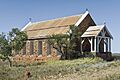
Holy Trinity Anglican Church (built 1883 / 1894–95)
-
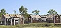
Former Roebourne Gaol by G Temple-Poole
-
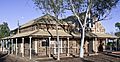
Roebourne Courthouse, G Temple Poole (1886)
-
Former Roebourne Shire Offices (1888)
-
Roebourne Post Office by G. Temple-Poole, built by Bunning Bros (1887)


.jpg)
.jpg)
.jpg)
