
Dampier, Western Australia facts for kids
Quick facts for kids DampierWestern Australia |
|||||||||
|---|---|---|---|---|---|---|---|---|---|

Map of Dampier, Western Australia and surrounding area.
|
|||||||||

Dampier
Location in Western Australia
|
|||||||||
| Established | 1965 | ||||||||
| Postcode(s) | 6713 | ||||||||
| Elevation | 0 m (0 ft) | ||||||||
| Area | [convert: needs a number] | ||||||||
| Location | |||||||||
| LGA(s) | City of Karratha | ||||||||
| State electorate(s) | North West | ||||||||
| Federal Division(s) | Durack | ||||||||
|
|||||||||
Dampier is a very important port town in the northwest of Western Australia. It is located in the Pilbara region, close to the city of Karratha. Dampier is a busy place where many industrial goods are handled.
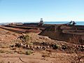
The port of Dampier is part of the Dampier Archipelago. It is mainly used to send out iron ore from Rio Tinto mines. It also handles LNG (liquefied natural gas) and salt. The port helps industries that deal with chemicals, salt, iron ore, and natural gas. In 2011, about 1,341 people lived in Dampier.
Contents
A Look Back: Dampier's Past and People

For thousands of years, the Yaburrara Aboriginal people lived in this area. They were the first inhabitants of this land.
The town of Dampier gets its name from Dampier Island. This island is about 3 kilometers off the Pilbara Coast. Both the island and the nearby Dampier Archipelago were named after an English explorer, William Dampier.
In 1963, Dampier Island became connected to the mainland. A special road and railway bridge, called a causeway, was built. This made the island into an artificial peninsula. Later, in 1979, this peninsula was renamed after Mount Burrup. This mountain is the highest point on the island.
In 1699, William Dampier explored the coast of New Holland, which is now Australia. He sailed past Dirk Hartog Island and into a place he called Shark Bay. He then explored the Dampier Archipelago, giving Rosemary Island its name.
The town of Dampier was built starting in 1965. Its main purpose was to serve as a hub for a railway. This railway carried iron ore from mines in Tom Price and Paraburdoo. By 1968, Dampier couldn't grow any bigger because of its location. So, a new town called Karratha was built nearby on the mainland.
Nature's Wonders: Dampier's Environment
The Burrup Peninsula is also known as Murujuga. This name means "Hip Bone Sticking Out" in the Yaburrara language. This area is famous for having the world's largest collection of petroglyphs. These are ancient rock carvings made by Aboriginal people.
There are 42 other islands in the Dampier Archipelago. The waters around these islands are full of amazing marine life. You can find whales, dugongs, turtles, coral, and sponges. Green turtles are also known to build their nests on the beaches of the Dampier Archipelago.
Weather Watch: Understanding Dampier's Climate
Dampier has a desert climate. This means it is very dry. The average rainfall each year is about 272.2 millimeters. Even though it gets some rain, it's still considered a desert. This is because a lot of water evaporates quickly due to the heat.
Summers in Dampier are extremely hot and humid. The air often feels very sticky. Dampier is one of the sunniest places in Australia and even the world. It gets over 3,700 hours of sunshine every year.
| Climate data for Dampier Salt | |||||||||||||
|---|---|---|---|---|---|---|---|---|---|---|---|---|---|
| Month | Jan | Feb | Mar | Apr | May | Jun | Jul | Aug | Sep | Oct | Nov | Dec | Year |
| Record high °C (°F) | 46.4 (115.5) |
47.1 (116.8) |
45.7 (114.3) |
42.2 (108.0) |
39.5 (103.1) |
32.5 (90.5) |
33.0 (91.4) |
37.3 (99.1) |
38.7 (101.7) |
43.2 (109.8) |
45.5 (113.9) |
46.5 (115.7) |
47.1 (116.8) |
| Mean daily maximum °C (°F) | 35.9 (96.6) |
36.0 (96.8) |
36.2 (97.2) |
34.4 (93.9) |
29.9 (85.8) |
26.6 (79.9) |
26.2 (79.2) |
27.7 (81.9) |
30.5 (86.9) |
32.7 (90.9) |
34.3 (93.7) |
35.7 (96.3) |
32.2 (90.0) |
| Mean daily minimum °C (°F) | 26.1 (79.0) |
26.5 (79.7) |
25.5 (77.9) |
22.8 (73.0) |
18.2 (64.8) |
15.1 (59.2) |
13.4 (56.1) |
14.6 (58.3) |
16.8 (62.2) |
19.7 (67.5) |
22.2 (72.0) |
24.6 (76.3) |
20.5 (68.9) |
| Record low °C (°F) | 17.5 (63.5) |
20.1 (68.2) |
20.0 (68.0) |
15.8 (60.4) |
10.4 (50.7) |
5.2 (41.4) |
4.6 (40.3) |
6.4 (43.5) |
8.6 (47.5) |
9.0 (48.2) |
11.4 (52.5) |
15.9 (60.6) |
4.6 (40.3) |
| Average precipitation mm (inches) | 36.3 (1.43) |
71.4 (2.81) |
46.7 (1.84) |
18.9 (0.74) |
31.0 (1.22) |
36.1 (1.42) |
11.7 (0.46) |
4.4 (0.17) |
1.5 (0.06) |
0.8 (0.03) |
1.4 (0.06) |
13.4 (0.53) |
272.8 (10.74) |
| Average precipitation days | 4.1 | 5.5 | 4.2 | 1.9 | 3.4 | 3.5 | 2.2 | 1.1 | 0.6 | 0.2 | 0.4 | 1.5 | 28.6 |
| Average afternoon relative humidity (%) | 50 | 51 | 44 | 37 | 38 | 40 | 35 | 35 | 32 | 37 | 41 | 45 | 40 |
| Mean monthly sunshine hours | 325.5 | 292.9 | 303.8 | 288.0 | 269.7 | 258.0 | 282.1 | 316.2 | 324.0 | 356.5 | 354.0 | 356.5 | 3,727.2 |
Fun Things to See: Dampier's Attractions
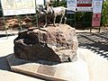
When you enter the town, you'll see a statue of "Red Dog". This was a famous red kelpie/cattledog. In the 1970s, he was known for wandering around the area and even getting rides to nearby towns. The statue has a special message: "Erected by the many friends made during his travels."
Another fun activity is fishing just off the coast. A popular fish to catch there is the barramundi.
Busy Waters: How Dampier's Port Works

The port of Dampier first opened in 1966. This was when the first iron ore from the Mount Tom Price mine arrived. It was transported by the Hamersley & Robe River railway to Parker Point. From there, it was loaded onto ships. Another part of the port, at East Intercourse Island, opened in 1972.
The port can load 140 million tonnes of iron ore each year. It usually takes about 24 to 36 hours to load one ship. Dampier is one of three main ports in the Pilbara region that export iron ore. The other two are Port Hedland and Port Walcott. The closest airport to the port is in Karratha, which is less than 20 kilometers away.
Images for kids
-
Iron Ore
-
"Red Dog" statue


Panoramas


