Dirk Hartog Island facts for kids
| Geography | |
|---|---|
| Location | Indian Ocean |
| Coordinates | 25°50′S 113°05′E / 25.833°S 113.083°E |
| Area | 620 km2 (240 sq mi) |
| Length | 80 km (50 mi) |
| Width | 15 km (9.3 mi) |
| Highest elevation | 188 m (617 ft) |
| Highest point | Herald Heights |
| Administration | |
|
Australia
|
|
| State | Western Australia |
| Region | Gascoyne |
| Shire | Shire of Shark Bay |
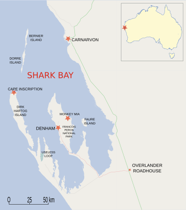
Dirk Hartog Island is a large island located off the Gascoyne coast of Western Australia. It is part of the amazing Shark Bay World Heritage Area. The island is about 80 kilometers (50 miles) long and between 3 and 15 kilometers (2 to 9 miles) wide. It is Western Australia's biggest and most western island, covering an area of 620 square kilometers (240 square miles). It sits about 850 kilometers (530 miles) north of Perth.
The island is named after Dirk Hartog, a Dutch sea captain. He was the first European to land on this part of the Western Australian coast in 1616. After visiting the island, Hartog sailed north-east along the mainland. He gave the Australian mainland one of its first known names, Eendrachtsland, named after his ship, the Eendracht. This name means "concord" or "harmony."
Today, Dirk Hartog Island is home to an important environmental project called Return to 1616. This project aims to bring the island back to how it was before European settlement. All introduced farm animals and wild animals like cats and goats have been removed. Now, eleven native animal species are being brought back to live on the island.
Contents
History of Dirk Hartog Island
Dirk Hartog Island has a rich history of exploration and settlement. Many European explorers visited the island over centuries.
Early European Visits and Plates
Dirk Hartog discovered the island on October 25, 1616. He was sailing the Dutch East India Company (VOC) ship Eendracht from Cape Town to Batavia (now Jakarta). To mark his visit, Hartog and his crew inscribed their names and the date on a pewter plate. They then nailed this plate to a post on the island.
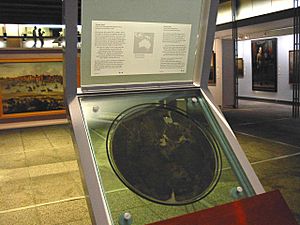
In 1697, another Dutch captain, Willem de Vlamingh, landed on the island. He found Hartog's plate. De Vlamingh replaced it with his own plate, which included a copy of Hartog's message. He took the original Hartog plate back to Amsterdam. You can still see it today in the Rijksmuseum.
French Explorers and Buried Bottles
On March 28, 1772, a French navigator named Louis Aleno de St Aloüarn visited the island. He became the first European to officially claim Western Australia for the French king, Louis XV. This happened during a ceremony on March 30. During the ceremony, one or more bottles were buried on the island. One bottle was said to contain a document claiming the land and a coin.
In 1998, a lead bottle cap with a coin was found at Turtle Bay. This discovery led to a bigger search by the Western Australian Museum. On April 1, 1998, an unbroken bottle with a similar lead cap and coin was found. However, no document claiming the land has been found yet.
In 1801, a French expedition led by Captain Emmanuel Hamelin visited the island. They found de Vlamingh's plate almost buried in the sand. The post it was on had rotted away. Captain Hamelin ordered that the plate be put back in its original spot.
In 1818, the French explorer Louis de Freycinet returned to the island. He had been an officer on Hamelin's 1801 trip. This time, he sent a boat ashore to get de Vlamingh's plate. It eventually made its way to Paris but was lost for over 100 years. It was found in 1940 and returned to Australia in 1947. You can now see it at the Western Australian Maritime Museum in Fremantle.
Pastoral History and Tourism
In 1869, Francis Louis von Bibra was given a lease to use the island. He started a sheep farm there. He also traded guano, which is bird droppings used as fertilizer, from the island's bays.
The Withnell brothers took over the island's lease in 1907. They thought it was a great place for a sheep station because there was no risk of rabbits invading. By 1909, about 12,000 sheep lived on the island. They produced around 400 bales of wool. The brothers planned to increase the flock to 25,000 sheep. By 1910, the number of sheep reached 14,200.
In 1919, the sheep station was put up for sale. It covered an area of 153,000 acres (619 square kilometers) and had about 19,000 sheep.
Around 1969, Perth Lord Mayor Sir Thomas Wardle bought the island as a private getaway for his family. He later retired there. Most of the island, except for the old farm homestead, eventually returned to government ownership. It became part of the Shark Bay Marine Park. Today, the island is an eco-tourism resort. It is managed by Wardle's grandson, Kieran Wardle.
On March 16, 2008, Australian Prime Minister Kevin Rudd announced that the wreck of the World War II German raider Kormoran had been found. It was on the seabed about 150 kilometers (93 miles) west of the island.
Geography of Dirk Hartog Island
Dirk Hartog Island has several important geographical features.
Key Locations on the Island
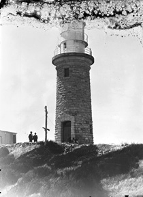
The northernmost point of the island is called Cape Inscription. This is where the famous historical plates were placed. It is also the location of the main lighthouse.
Turtle Bay is a bay facing north, right next to Cape Inscription.
The most south-westerly point is Surf Point. It is located at a channel called South Passage. This channel is across from Steep Point on the mainland.
Environment and Wildlife
The island is mostly covered by sand dunes with scrubby plants. It used to be a large sheep farm, with up to 20,000 sheep at one time. Now, Dirk Hartog Island is a National Park, and all the sheep have been removed. To the east, it borders the Shark Bay Marine Park. The entire island is part of the Shark Bay World Heritage Area. A small part of the island is still leased to the Wardle family for tourism. The area is also popular for recreational fishing.
Important Nesting Sites
Dirk Hartog Island is a very important place for loggerhead sea turtles to lay their eggs. Green turtles also nest on the beaches here. The island is home to a special type of white-winged fairy-wren found nowhere else.
Quoin Bluff, located halfway along the eastern side of the island, has a large pied cormorant nesting colony. This area, along with Freycinet Island to the south-east, is recognized as an Important Bird Area by BirdLife International.
The Return to 1616 Project
In October 2018, a 20-year project was completed. The island was declared free of wild cats, goats, and sheep. This was a big step for the Return to 1616 environmental project. It means that 11 native animals can now be brought back to the island. Most of these animals had disappeared after 150 years of farming and hunting by introduced animals.
The Return to 1616 project aims to bring back nine native species that used to live on the island. These include the western barred bandicoot, burrowing bettong, Shark Bay mouse, greater stick-nest rat, western thick-billed grasswren, brush-trailed bettong, heath mouse, desert mouse, mulgara, dibbler, and chuditch.
Two more mammal species, the rufous hare-wallaby and banded hare-wallaby, are also being brought back. Scientists believe they likely lived on the island in the past. These two were the first to be returned after the wild cats were removed in September 2017. The western barred bandicoot and the dibbler were brought back in October 2019.
|
See also
 In Spanish: Isla Dirk Hartog para niños
 | Bessie Coleman |
 | Spann Watson |
 | Jill E. Brown |
 | Sherman W. White |


