
Cape Town facts for kids
Quick facts for kids
Cape Town
|
|||
|---|---|---|---|
|
Cape Town CBD
Bo-Kaap
V&A Waterfront
Kirstenbosch Garden
Camps Bay Beach
Houses of Parliament
Devil's Peak and Table Mountain from Signal Hill
|
|||
|
|||
| Nicknames:
Mother City, Tavern of the Seas (archaic)
|
|||
| Motto(s):
Spes Bona (Latin for "Good Hope")
|
|||

Cape Town
Location in Western Cape

Cape Town
Location in South Africa

Cape Town
Location in Africa
|
|||
| Country | |||
| Province | |||
| Municipality | City of Cape Town | ||
| Founded | 6 April 1652 | ||
| Municipal government | 1839 | ||
| Government | |||
| • Type | Metropolitan municipality | ||
| Area | |||
| • Capital city (legislative branch) | 2,461 km2 (950 sq mi) | ||
| Highest elevation | 1,590.4 m (5,217.8 ft) | ||
| Lowest elevation | 0 m (0 ft) | ||
| Population | |||
| • Rank | 13th in Africa 2nd in South Africa |
||
| • Urban
(2011)
|
433,688 | ||
| • Urban density | 1,083/km2 (2,800/sq mi) | ||
| • Metro
(2022)
|
4,772,846 | ||
| • Metro density | 1,952/km2 (5,060/sq mi) | ||
| Demonym(s) | Capetonian | ||
| Racial makeup (2022) | |||
| • Black | 45.7% | ||
| • Coloured | 35.1% | ||
| • White | 16.2% | ||
| • Indian/Asian | 1.6% | ||
| • Other | 1.5% | ||
| First languages (2011) | |||
| • Afrikaans | 34.9% | ||
| • Xhosa | 29.2% | ||
| • English | 27.8% | ||
| Time zone | UTC+2 (SAST) | ||
| Postal codes (street) |
7400–8099
|
||
| PO box |
7000
|
||
| HDI | 0.82 – very high | ||
| GMP (2020) | US$121 billion | ||
| GMP per capita (2011) | US$19,656 | ||
.jpg)


.jpg)

.jpg)


Cape Town is the legislative capital of South Africa. This means it's where the country's laws are made. It's the oldest city in South Africa and home to the Parliament of South Africa. Cape Town is the second-largest city in the country by population, right after Johannesburg. It's also the biggest city in the Western Cape province.
The city is famous for its beautiful harbour and its amazing natural surroundings. It's part of the Cape Floristic Region, which has unique plants. Famous landmarks include Table Mountain and Cape Point. Cape Town has often been called one of the best cities in the world for travelers.
Cape Town is located on the shore of Table Bay. The City Bowl area, which includes the main business district, is the oldest part of the Western Cape. It has a rich cultural history. The city was started by the Dutch East India Company (VOC) in 1652. It was a place for Dutch ships to stop and get supplies on their way to East Africa, India, and the Far East.
Over time, Cape Town grew from a small supply station into an important economic and cultural center. For a long time, it was the largest city in southern Africa. This was true until gold was discovered in Witwatersrand and Johannesburg grew rapidly.
The city's area stretches along the Atlantic Ocean coastline, including False Bay. It reaches the Hottentots Holland Mountains in the east. Table Mountain National Park is right inside the city. There are also many other nature reserves and protected marine areas nearby. These places help protect the diverse plants and animals of the region.
Contents
History of Cape Town
Cape Town has a long and interesting history.
Early Explorers and Settlers
.jpg)
The first signs of people living in this area date back 15,000 to 12,000 years ago. The first European to arrive was Bartolomeu Dias in 1488. He called it "Cape of Storms." Later, it was renamed "Cape of Good Hope" because it offered a new sea route to Asia.
In 1497, another Portuguese explorer, Vasco da Gama, also saw the Cape of Good Hope. In 1510, a battle took place at Salt River. Portuguese admiral Francisco de Almeida and his men were defeated by the Khoikhoi people. The Khoikhoi used specially trained cattle in the fight.
In the late 1500s, ships from many European countries stopped in Table Bay. They traded tobacco, copper, and iron with the Khoikhoi. In return, they received fresh meat and other supplies for their long journeys.
Dutch Rule


In 1652, Jan van Riebeeck and others from the Dutch East India Company (VOC) arrived. They were sent to build a supply station for ships. This station became the Fort de Goede Hoop, later replaced by the Castle of Good Hope.
The settlement grew slowly at first. There weren't enough workers. So, people were brought in from Indonesia and Madagascar to work. Many of today's Cape Coloured and Cape Malay communities are descendants of these people.
During the Dutch period, many new plants were brought to the Cape. These included grapes, cereals, and fruit trees. They greatly changed the farming and economy of the region.
British Rule

Great Britain took control of Cape Town in 1795. This happened during the Napoleonic Wars when the Dutch Republic allied with France. The city was briefly returned to the Dutch in 1803 but was taken back by the British in 1806. In 1814, Cape Town officially became part of the United Kingdom.
The city became the capital of the new British Cape Colony. This colony grew a lot during the 1800s. In 1833, slavery was ended in the colony. This freed over 5,500 enslaved people in Cape Town.
By the late 1800s, Cape Town's importance in southern Africa began to shift. Johannesburg and Pretoria became more dominant in the 20th century.
South African Period

In 1910, the Union of South Africa was formed. Cape Town became its legislative capital. This meant it was still where the country's laws were made. By 1936, Johannesburg had become the largest city in the country. In 1945, the Cape Town foreshore was expanded, adding new land to the city center.
The Apartheid Era
Before the mid-1900s, Cape Town was a city where people of different backgrounds lived together. But in 1948, the National Party came to power. They introduced a system called apartheid, which meant racial segregation. This system separated people based on their race.
Under apartheid, areas in Cape Town were divided by race. Some mixed-race neighborhoods were cleared, and people were forced to move. A famous example is District Six. After 1965, it was declared a whites-only area. All houses were destroyed, and over 60,000 residents were forced to leave. Many moved to the Cape Flats.
Black South Africans were often moved to specific areas called townships, like Langa. The government also tried to limit Black Africans from working in the Cape. This policy was not supported by all groups and caused a lot of disagreement.
Cape Town was home to many leaders who fought against apartheid. Robben Island, an island 10 km from the city, was a maximum-security prison. Many political prisoners, including Nelson Mandela, were held there. Mandela spent 18 of his 27 years in prison on Robben Island.
On February 11, 1990, Nelson Mandela gave his first public speech after being released. He spoke from the balcony of Cape Town City Hall. This speech marked the beginning of a new era for South Africa. The first democratic election was held four years later in 1994.
After Apartheid
Since apartheid ended, Cape Town has changed a lot. The city has seen economic growth and development. It has become a major economic center in South Africa, attracting visitors and businesses. The Democratic Alliance (DA) political party has been in charge of Cape Town since 2006. They are known for making the city run well and improving safety.
Many people in South Africa believe the Western Cape is the best-governed province and city. In 2014, Cape Town was named World Design Capital. It continues to be a top tourist spot, winning awards for best travel city.
However, the effects of apartheid's planning are still visible. There are big differences between wealthy areas and poorer townships. Many Black South Africans still live in informal settlements. These areas often have limited access to basic services like healthcare and education. Unemployment is still a challenge, especially for groups who were disadvantaged in the past.
From 2015 to 2018, Cape Town faced a serious water shortage. The city successfully cut its water use by more than half. This helped avoid "Day Zero," when the city might have run out of water.
In 2021 and 2023, there were conflicts between rival mini-bus taxi companies. These events caused some safety concerns. Since the 2010s, a small movement for Cape independence has also grown.
Geography and Natural Environment
.jpg)
.jpg)

Cape Town is located at about 33.55° South and 18.25° East. This is similar to cities like Sydney in Australia.
Table Mountain is a famous landmark with its flat top and steep cliffs. It's over 1,000 meters high. On either side are Devil's Peak and Lion's Head. Together, they form a dramatic mountain backdrop for the City Bowl. Sometimes, a thin cloud called the "tablecloth" forms on top of Table Mountain.
South of the city, the Cape Peninsula stretches 40 km into the Atlantic Ocean. It ends at Cape Point. There are over 70 peaks higher than 300 meters within Cape Town's city limits. Many suburbs are on the Cape Flats, a large flat plain that connects the peninsula to the mainland. Cape Town is known for its long coastline, rugged mountains, and valleys.
City Limits and Surrounding Areas
Cape Town has grown a lot over time. It started as a small settlement at the foot of Table Mountain. Now, it includes the entire Cape Peninsula to the south, the Cape Flats, and areas to the east and north. Robben Island in Table Bay is also part of Cape Town.
The city is bordered by the Atlantic Ocean to the west and False Bay to the south. To the north and east, it meets other towns in the Western Cape. The City of Cape Town municipality covers a wider area called the Cape Metropole. This includes towns like Atlantis, Bellville, Hout Bay, and Somerset West.
The Cape Peninsula is 52 km long and has an area of about 470 square kilometers. It has a lot of different landscapes, from rocky coastlines to sandy beaches. The Cape Flats is a flat, sandy area east of the Cape Peninsula. It used to be mostly wetlands and sand dunes.
The Helderberg area is east of the Cape Flats. It's mostly residential but also produces wine. It includes towns like Somerset West and Gordon's Bay. This area is also very mountainous and has many different plant and animal species.
To the east of the Hottentots Holland mountains is the Steenbras River valley. The Steenbras Dam was built here to supply water to Cape Town. Robben Island was declared a World Heritage Site in 1999. It was used as a prison for almost 400 years. It was also a place for people with leprosy and a post office.
The coastline of Cape Town is about 307 km long. It stretches from Silwerstroomstrand on the west coast to Kogelbaai on the east coast of False Bay.
Climate
.jpg)
Cape Town has a Mediterranean climate. This means it has mild, wet winters and dry, warm summers. Winter is from June to September. During this time, cold fronts from the Atlantic Ocean bring rain and strong winds. Winter temperatures average around 18°C maximum and 8.5°C minimum.
It rarely snows or frosts in the city itself, but it can happen on Table Mountain. The city gets about 515 mm of rain each year. In the Southern Suburbs, closer to the mountains, rainfall can be much higher.
Summer is from December to March. It's warm and dry, with average temperatures around 26°C maximum and 16°C minimum. Sometimes, a hot wind called the "Berg Wind" blows from the dry interior.
Spring and summer often have a strong wind from the south-east. It's known as the "Cape Doctor" because it helps clear air pollution. Cape Town gets about 3,100 hours of sunshine every year.
Ocean temperatures vary a lot. On the Atlantic side, it can be around 10°C. In False Bay, it can be over 22°C. Cape Town doesn't have many thunderstorms.
Climate Change and Future Outlook
Scientists have studied how climate change might affect Cape Town. A study in 2019 suggested that by 2050, Cape Town's climate could be similar to Perth, Australia. This means temperatures would increase.
Another report in 2022 said that Cape Town is one of 12 major African cities that could be greatly affected by rising sea levels. This could lead to significant costs if measures aren't taken to protect the city.
Water and Ocean Temperatures

Cape Town's coastal water temperatures range from cold to mild. The Atlantic side is colder, averaging 10-15°C. This is due to the Benguela Current. The False Bay coast is much warmer, averaging 16-22°C. In summer, False Bay can reach over 20°C.
Plants and Animals

Cape Town is in a special area called the Cape Floristic Region. This region has one of the highest levels of different plant and animal species in the world. It's a World Heritage Site.
Table Mountain alone has about 2,200 plant species. Many of these, like different types of proteas, are found nowhere else. The main plant type is Peninsula Sandstone Fynbos.
However, as the city has grown, many of these natural areas have been built over. This means over 300 plant species are now threatened, and 13 have become extinct. The Cape Peninsula has the highest number of threatened species for its size in the world.
To protect these plants, there are over 30 nature reserves, including Table Mountain National Park. In 2019, Cape Town won an international competition for observing the most species.
Whale watching is a popular activity. You can see southern right whales and humpback whales from August to November. Bryde's whales and orca can be seen all year. African penguins live at Boulders Beach near Simon's Town.
City Government
Cape Town is run by a city council with 231 members. These members are elected by the people. The city is divided into 116 areas called wards, and each ward elects a councillor.
In the 2021 elections, the Democratic Alliance (DA) party won the most seats. Geordin Hill-Lewis was elected as the Mayor of Cape Town.
Cape Town is known for its good governance. The city's spending on things like roads and buildings, its stable politics, and its public services are considered among the best in South Africa. In 2025, Cape Town was the only major city in South Africa to receive a "clean audit" for its finances for the third year in a row. This means the city manages its money very well.
-
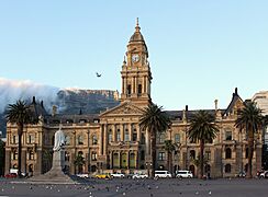
The Old Cape Town City Hall as seen from the Grand Parade.
-
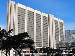
The Cape Town Civic Centre, the main offices of the City of Cape Town.
-
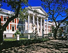
The Western Cape Provincial Parliament
-
South Africa's national parliament building is located in Cape Town.


_(cropped_wo_cars).jpg)

International Connections
Cape Town has agreements with nineteen other cities around the world. These are called "sister city" agreements. They help cities share ideas and work together.
.jpg)
In 2022, the City of Cape Town showed its support for Ukraine. The Old City Hall was lit up in the colors of the Ukrainian flag. This was different from the national government's neutral stance.
People of Cape Town


In 2011, the population of the City of Cape Town was about 3.74 million people. By 2022, it had grown to about 4.77 million. The city's population is expected to keep growing, reaching around 5.46 million by 2030.
Many different languages are spoken in Cape Town. In 2011, about 35.7% of people spoke Afrikaans, 29.8% spoke Xhosa, and 28.4% spoke English.
Cape Town has a young population. In 2022, the average age was 31. About 40% of the population was under 25.
The average household income in the Western Cape, where Cape Town is located, is the highest in South Africa. This means people in this province generally earn more money.
More people are moving to Cape Town from other parts of South Africa. This is sometimes called "semigration." People move for better services and job opportunities.
Religions in Cape Town

Most people in Cape Town are Christian (82.3% in 2015). There are many churches and cathedrals. Islam is the second largest religion, with a long history in the city. The Auwal Mosque is South Africa's first mosque.
Cape Town also has a significant Jewish population. They have several synagogues, including the historic Gardens Shul. There are also Hindu and Buddhist temples.
Safety and Security
.jpg)
Cape Town has been working hard to improve safety. The city has different groups that work together to keep people safe. These include the Cape Town Metropolitan Police Department, the Traffic Service, and the Law Enforcement Advancement Plan (LEAP).
In early 2025, the city announced that crime levels were decreasing in some areas. This was due to daily patrols and working with the Western Cape Government. The city is also using more technology, like CCTV cameras and drones, to help fight crime.
The Cape Town Central City Improvement District (CCID) helps keep the city center safe and clean. They have public safety officers and work with other security groups. Since 2002, crime in the CBD has reduced significantly.
The city also has a volunteer service called the Law Enforcement Auxiliary Service (LEAS). These volunteers help with patrols and other duties.
Cape Town uses about 2,000 CCTV cameras to monitor the city. These cameras help prevent crime and provide evidence. The city also uses drones with special cameras to watch for suspicious activity. These drones can detect body heat and track vehicles.
Many residents also use private security companies for extra protection. Cape Town is a leader in South Africa for its policing and security innovations.
Economy
Cape Town is a major economic center in South Africa, similar to Johannesburg. It's also the third-largest economic hub in Africa. The city's economy is diverse, meaning it doesn't rely on just one type of business.
The financial sector is important, but the tech sector is growing fast. Cape Town also has a strong "Green Economy," with lots of money invested in environmentally friendly businesses.
Income and Jobs
Cape Town has the highest average household income in South Africa. It also has the lowest unemployment rate and a strong property market. In 2025, Cape Town added 86,000 jobs, going against the national trend. The Mayor believes this is because of good city management and investments in infrastructure.
The Western Cape's unemployment rate is much lower than the national average. Jobs in the formal sector grew by 3.1% in 2024.
Economic Growth
Cape Town is known as an entrepreneurial city. People here are more likely to start new businesses. It's also a big center for the information technology industry in Africa. Many tech startups are based here.

The city has the largest film industry in the Southern Hemisphere. It brings in a lot of money and creates many jobs. Cape Town is also a popular place for conferences and meetings. The Cape Town International Convention Centre (CTICC) hosts many large events.
Major Companies
Cape Town is home to the main offices of many large South African companies. These include:
- Retailers like Woolworths, Pick n Pay, and Shoprite.
- Tech companies, as Cape Town is a tech hub.
- Financial companies like Sanlam and Old Mutual Park.
- Other industries like publishing, design, and tourism.
Big international companies like Johnson & Johnson and Amazon also have offices or facilities in Cape Town.
Tourism


The Western Cape is a very important tourist region. Tourism makes up a big part of the province's economy. Cape Town is a popular international tourist spot because of its mild climate, natural beauty, and good facilities.
Tourists love to visit Table Mountain. You can hike up or take the Table Mountain Cableway. Cape Point is another stunning headland. Many people drive along Chapman's Peak Drive for amazing ocean views. You can also go up Signal Hill for views of the city.
Cape Town's beaches are very popular. You can visit different beaches, each with its own feel. The Atlantic Seaboard is known for its beautiful scenery and beaches like Clifton and Llandudno. Boulders Beach is famous for its colony of African penguins.
The city has many cultural attractions. In the Cape Town CBD, you can find theaters, the Parliament buildings, museums, and the Castle of Good Hope. The Victoria & Alfred Waterfront is a popular place for shopping and dining. It's also where ferries leave for Robben Island.
Cape Town offers many adventure activities, like helicopter rides, paragliding, and scuba diving. Surfing is also popular. The city works with Cape Town Tourism to promote itself to visitors.
Housing
Cape Town has different types of homes, including houses, townhouses, and apartments. Older neighborhoods often have larger houses. Newer areas have a mix of housing types.
Home Ownership
Cape Town has the most expensive average home prices in South Africa. In September 2024, the average property price was R2.23 million. This shows that property values have grown a lot over the past decade.
Property prices in Cape Town have increased much faster than in other major South African cities. To afford an average home in Cape Town, you need a higher salary than in other provinces.
Areas like the Southern Suburbs, Atlantic Seaboard, and City Bowl are generally more expensive. The Cape Flats and Northern Suburbs tend to be more affordable.
Some suburbs have seen huge increases in property value. For example, in 2025, house prices in Kalk Bay grew by about R1 million each year since 2020. This is because more people want to live in the Western Cape.
Cape Town's property values increase by about 10% each year. This is due to good local government, a strong economy, and people moving to the city.
Rentals
In 2025, the average rent for a 2-bedroom apartment in Cape Town was about R12,000 per month. However, this can vary a lot. Some areas have rents as low as R7,000, while others can be as high as R30,000.
Rental prices in Cape Town increased by 5.2% in 2025. The city also has a very low rental vacancy rate, meaning most rental properties are occupied.
The University of Cape Town (UCT) attracts many international students. This increases the demand for rental properties. The Western Cape has the highest rental prices in South Africa and the lowest number of tenants who are behind on payments.
Infrastructure and Services
Cape Town invests a lot in its infrastructure. For the 2025 to 2026 financial year, the city's budget for infrastructure was R120 billion over 10 years. This is more than the combined budgets of the three major cities in the Gauteng province.
Most goods are handled at the Port of Cape Town or Cape Town International Airport. Many shipbuilding companies have offices in Cape Town. The city also has important commercial areas with many offices and company headquarters.
Telecommunications
Cape Town has a very good internet and phone network.
- Fibre Internet: Many homes and businesses have super-fast fibre optic internet. Companies like Vumatel and Octotel offer speeds up to 1 Gigabit per second.
- Undersea Cables: The city gets its main internet connection from large undersea cables that connect South Africa to other continents.
- Mobile Networks: There is excellent 5G and 4G mobile phone coverage across the city from major providers like Vodacom and MTN.
Health Services
The city has many well-equipped clinics and hospitals. These include public hospitals like Groote Schuur Hospital, famous for the first human heart transplant. There are also many private hospitals run by groups like Mediclinic and Netcare.
Education


Public schools in Cape Town are managed by the Western Cape Education Department. There are also many private schools.
Cape Town has three public universities:
- The University of Cape Town (UCT) is a leading university in Africa. It's known for its strong academic programs.
- The University of the Western Cape (UWC) has received more funding recently.
- The Cape Peninsula University of Technology (CPUT) offers practical education.
Stellenbosch University is also a top university nearby, with some campuses close to Cape Town. Many students from around the world choose to study in Cape Town.
Energy Supply

Cape Town has a more stable energy supply than other parts of South Africa. It has the country's only nuclear power station, Koeberg. The city also uses a system at Steenbras Dam to store energy. This helps Cape Town avoid power outages when the national grid has problems.
In January 2024, Cape Town announced plans to become energy self-sufficient. The goal is to protect the city from power cuts by 2026 and eventually generate all its own electricity. The city is buying power from independent producers and using solar energy.
Cape Town launched a "Cash for Power" program in 2024. This allows households to earn money by selling extra solar power back to the city. By February 2025, over 1,800 people were part of this program.
The city is also building new solar plants. There are plans for a 60 MW solar plant at Paardevlei. Cape Town aims for its municipal buildings to have zero carbon emissions by 2030.
Water Supply
The Western Cape Water Supply System (WCWSS) provides water to Cape Town. It's a system of dams, pipelines, and tunnels.
Water Challenges
From 2017 to 2018, Cape Town faced a serious water shortage. Dam levels dropped very low. There was talk of "Day Zero," when the city might run out of water. However, the city worked hard to reduce water use. Residents cut their daily water usage by more than half. This helped avoid Day Zero, and good rains in 2018 and 2020 helped dam levels recover.
New Water Plans
Cape Town has a "New Water Program" to add more water to its supply. This includes using desalination (removing salt from seawater) and tapping into underground water. In 2024, the city announced plans to build a desalination plant. This plant would produce 50 to 70 million liters of water a day by 2030.
Transport
Air Travel

Cape Town International Airport handles both local and international flights. It's the second-largest airport in South Africa. It has flights to other parts of Africa, Europe, Brazil, the United States, and many places within South Africa.
The airport was upgraded for the 2010 FIFA World Cup. It has a new terminal, parking garages, and a new bus system. Cape Town is also one of five cities in the world with flights to Antarctica.
Sea Travel

Cape Town has always been an important port city. The Port of Cape Town is in Table Bay, near the city center. It's a busy hub for ships traveling between Latin America, Asia, and Africa. It's the second-busiest container port in South Africa.
Simon's Town Harbour is the main base for the South African Navy.
Train Travel

The Shosholoza Meyl offers long-distance train services from Cape Town to Johannesburg. Metrorail runs commuter trains around Cape Town and its suburbs. There are also luxury tourist train routes.
Road Travel
Cape Town is the starting point for three major national roads: the N1, N2, and N7. These roads connect Cape Town to other major cities in South Africa.
The city also has many regional and metropolitan roads. Cape Town has the worst traffic congestion in South Africa.
Buses
Golden Arrow Bus Services operates bus services in Cape Town. There are also long-distance bus services to other cities.
MyCiTi Bus System
.jpg)
Cape Town has a public transport system called MyCiTi. It uses special buses that run on dedicated busways. MyCiTi connects the Airport to the city center and many other areas like Blouberg, Atlantis, and Hout Bay. It's designed to be easy for everyone to use.
Taxis

Cape Town has different types of taxis. You can use ride-hailing apps like Bolt and Uber. There are also traditional metered taxis and mini-bus taxis. Mini-bus taxis are a common way for many people to get around.
Future Plans
Cape Town has a "Vision 2050" project to upgrade its infrastructure. This 25-year plan aims to make Cape Town a "future-fit city of opportunities for all." Some goals include:
- Public transport for 75% of all trips.
- 35% of electricity from alternative sources by 2030.
- More water from non-surface sources by 2040.
- Creating 50,000 new housing opportunities each year.
- Taking over the passenger rail system from the national government.
- Expanding the city's policing powers.
- Recycling more waste.
- Using more digital technology and artificial intelligence.
- Planting 100,000 trees by 2050.
- Increasing the city's economic output by 120% by 2050.
Culture


Cape Town is famous for its architecture, especially the Cape Dutch style. This style mixes Dutch, German, French, and Indonesian influences. You can see it in places like Constantia and along Long Street. The only complete windmill in South Africa, Mostert's Mill, is in Cape Town.
Cape Town was named the World Design Capital in 2014. It's also recognized as a "Design City" by UNESCO. The Artscape Theatre Centre is the largest performing arts venue.
.jpg)

The annual Cape Town Minstrel Carnival, also called Kaapse Klopse, is a big festival on January 2nd. Teams of minstrels wear bright costumes and perform music.
The city also has the 36-hectare Kirstenbosch National Botanical Garden. It has protected natural forests and fynbos plants, along with many animals and birds. It's home to over 7,000 plant species, including many rare ones.
Food and Cuisine

Cape Town has unique foods. Bobotie is a savory-sweet spiced meat dish from the 17th century. The Gatsby is a large sandwich filled with chips and other toppings. The koe'sister is a traditional Cape Malay pastry.
Malva pudding is a sticky sweet dessert often served with custard. Cape Town is also the home of the South African wine industry. Wineries like Groot Constantia are still in the city.
Media

Several newspapers and magazines have offices in Cape Town. Major English papers include the Cape Argus and the Cape Times. The main Afrikaans paper is Die Burger. There are also many local community newspapers.
Cape Town has several radio stations. Some play pop music, while others play jazz, classical music, or talk radio. Cape Town TV is a local TV station that focuses on documentaries. Many production companies also work in the city.
Sports and Recreation


Cape Town's most popular sports are cricket, soccer, swimming, and rugby union. In rugby, the Western Province team plays at Cape Town Stadium. The Stormers team also plays here. Cape Town has hosted major rugby events, including parts of the 1995 Rugby World Cup.
Soccer is also very popular. Cape Town has hosted matches for the 2010 FIFA World Cup at the Cape Town Stadium.
In cricket, the Cape Cobras team plays at the Newlands Cricket Ground. This ground often hosts international matches.
Cape Town has experience hosting big sports events. The Cape Town Cycle Tour is the world's largest individually timed road cycling race. The Absa Cape Epic is a huge mountain bike race. The city also hosts the Africa leg of the World Rugby 7s event.
There are several golf courses in Cape Town. The coastline is great for scuba diving and surfing.

Images for kids
-
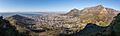
Cape Town's City Bowl and CBD viewed from Lion's Head in May (late autumn)
-
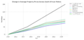
The price of an average property in Cape Town has grown significantly in recent years, especially when compared to other South African metros

See also
 In Spanish: Ciudad del Cabo para niños
- Cape Colony
- Timeline of Cape Town
- Western Cape
- Cape Town Tourism, the city's official destination marketing organization
