
Cape Point facts for kids


Cape Point is a famous piece of land that sticks out into the ocean. It's at the very end of the Cape Peninsula in South Africa. This peninsula is a beautiful, mountainous area about 30 kilometers (19 miles) long. It's the southwestern tip of the whole African continent!
Close to the northern end of this peninsula are Table Mountain and the city of Cape Town. Cape Point itself is located at 34°21′26″S 18°29′51″E / 34.35722°S 18.49750°E. It's about 2.3 kilometers (1.4 miles) east of the Cape of Good Hope.
Even though Cape Point and the Cape of Good Hope are very well known, neither of them is the southernmost point of mainland Africa. That special spot is Cape Agulhas, which is about 150 kilometers (93 miles) to the east-southeast.
Contents
High Points and Views
The land at Cape Point rises sharply from the sea. It forms two main peaks. The higher peak has an old lighthouse on top. There's also a smaller peak about 100 meters (328 feet) further south.
To help visitors get up the hill, there's a funicular railway called the Flying Dutchman Funicular. It takes you from a car park up to just below the old lighthouse. From there, a few steps lead to a viewing platform. You can get amazing views of the ocean and coastline from here!
The Lighthouses

Cape Point has two lighthouses. The old lighthouse, built in 1860, sits very high up, about 262 meters (860 feet) above sea level. However, it had a problem: it was too high! Ships sailing around the point would see its light too early. This made them think they were further away from the land than they actually were, causing them to sail too close to the dangerous rocks.
Also, the old lighthouse was often hidden by fog. On April 18, 1911, a ship called the Lusitania crashed near Cape Point because of this fog. This accident led to the decision to build a new lighthouse.
The new lighthouse is much lower, only 87 meters (285.5 feet) above sea level. This means ships can't see its light until they are a safe distance away from the coast. The light from the new Cape Point lighthouse is very powerful. It can be seen from up to 63 miles (101 kilometers) away!
Interesting Facts About Cape Point

Cape Point is part of the beautiful Table Mountain National Park. This section of the park is called the Cape of Good Hope. It covers the entire southern tip of the Cape Peninsula. This area is wild and natural, and it's a safe home for many seabirds. The plants here are mostly a type of local vegetation called Peninsula Sandstone Fynbos.
Many people think that Cape Point is where the cold Benguela Current from the Atlantic Ocean meets the warm Agulhas Current from the Indian Ocean. However, this isn't quite right. These two currents actually mix and swirl together along the southern and southwestern coast of South Africa, usually between Cape Agulhas and Cape Point.
There isn't a clear "line in the ocean" where the water changes color. But the mixing of these currents does create strong and dangerous waves, tides, and currents around Cape Point. Because of these rough seas, many ships have been wrecked here over hundreds of years.
Fishing is popular along the coast, but it can be very dangerous. Unpredictable waves have swept many fishermen off the rocks. False Bay, which is east of Cape Point, is home to the naval port of Simon's Town. This bay is also known for its great white sharks, which hunt the Cape fur seals living in the area.
Climate Research at Cape Point
Cape Point is also home to an important scientific station. It's one of the Global Atmosphere Watch stations that study the Earth's atmosphere. A long time ago, in the early 1900s, people sometimes saw icebergs from Antarctica from Cape Point. However, no icebergs have been seen recently. Some scientists believe this might be due to global warming.
Gallery
-
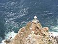
The "new" lighthouse from 1919, atop Dias Point, which is essentially Cape Point.
-
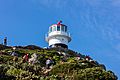
The old lighthouse at the top of the Cape Point promontory, used from 1860 to 1919.
-

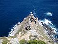
Cape Point and the new lighthouse as seen from the west. False Bay is beyond.
-
White surf breaks around Dias Rock, just offshore from the point.


See also
 In Spanish: Cabo Point para niños
