
False Bay facts for kids
Quick facts for kids False Bay |
|
|---|---|

Eastern False Bay coast aerial view looking somewhat south of east: Gordon's Bay (left) to Cape Hangklip (right)
|
|

False Bay
Location in Western Cape

False Bay
Location in South Africa
|
|
| Coordinates | 34°13′47″S 18°38′43″E / 34.22972°S 18.64528°E |
| Native name | Valsbaai |
| Ocean/sea sources | Southern Atlantic Ocean |
| Basin countries | South Africa |
False Bay (in Afrikaans Valsbaai) is a large bay found in the Atlantic Ocean in the far southwest of South Africa. It sits between the tall Cape Peninsula mountains and the Hottentots Holland Mountains.
The bay opens to the south, with Cape Point on the west side and Cape Hangklip on the east. The northern part of the bay is a flat area called the Cape Flats. A big part of False Bay is along the coast of the City of Cape Town. It includes parts of the Table Mountain National Park Marine Protected Area and all of the Helderberg Marine Protected Area.
False Bay is also home to South Africa's biggest naval base at Simon's Town. This base was once used by the Royal Navy. You can also find small fishing harbors at Kalk Bay and Gordon's Bay.
Contents
Discovering False Bay: Location and Features


The western side of False Bay is bordered by the Cape Peninsula. Along this coast, you'll find smaller bays like Smitswinkel Bay, Simon's Bay, and Fish Hoek Bay. At Muizenberg, the coast becomes sandy and flat, curving east across the Cape Flats to Gordon's Bay. This forms the northern edge of False Bay.
From Gordon's Bay, the coastline turns south, winding along the base of the Hottentots Holland Mountains to Cape Hangklip. This point is almost at the same latitude as Cape Point. The highest mountain on this side is Kogelberg, which is 1,269 meters tall.
False Bay is roughly square-shaped, about 30 kilometers wide from north to south and east to west. Its entire southern side is open to the ocean. The bay covers an area of about 1,090 square kilometers and holds about 45 cubic kilometers of water. This means its average depth is around 40 meters. The coastline around the bay is about 116 kilometers long.
The eastern and western shores of the bay are very rocky and mountainous. In some places, huge cliffs drop straight into the water. The northern shore, however, has a very long, curving, sandy beach. This sandy area is the southern edge of the Cape Flats.
Many suburbs of Greater Cape Town now stretch across the Cape Flats. They go from Simon's Town on the Cape Peninsula to Gordon's Bay in the northeast. There are also two small towns, Rooi-Els and Pringle Bay, on the east coast of the bay.
The Bay's Floor: What's Beneath the Water?

The bottom of False Bay is generally smooth and quite shallow. It slopes gently downwards from north to south, reaching about 80 meters deep at the center of the bay's mouth. The seabed is covered with sand and mud, with the finest mud found in the middle of the bay.
One interesting feature is a long ridge of rock that stretches south from the Strand area. The southern end of this ridge is called Steenbras Deep.
There is one real island in the bay called Seal Island. It's a rocky piece of granite, about 200 meters long and less than 10 meters above sea level. It's about 6 kilometers south of Strandfontein. There are also many small rocky islets and underwater rocks that are close to the surface. The biggest and most important of these is Whittle Rock. This large granite outcrop is about a kilometer wide and rises to within 4 meters of the surface. It's about halfway into the bay from the Cape Peninsula side.
A Look Back: History of False Bay

Long ago, before Europeans arrived, the Khoisan people lived around False Bay. They collected seafood from the shores, and their shell middens (piles of shells) show they used the bay for over 10,000 years.
The first European to see the bay was Bartolomeu Dias in 1488. He called it "the gulf between the mountains." The name "False Bay" came about because sailors often confused it with Table Bay to the north. Sailors returning from the east sometimes mistook Cape Point for Cape Hangklip, which looked similar. Cape Hangklip was known as Cabo Falso, or False Cape, by early Portuguese sailors, and the bay got its name from this "false" cape.
Commercial fishing began in False Bay in the late 1600s, soon after the Dutch settled in the area. Over time, many fishing methods were banned in False Bay. For example, trawling and gillnetting were stopped because they were catching too many fish, causing problems with other fishermen, and harming the environment. However, illegal gillnetting is still a problem today.
In the past, people also collected penguin eggs (until 1968), hunted whales (until 1975), hunted seals for their fur (until 1984), and collected guano (bird droppings used as fertilizer) until 1991. All these activities severely harmed the animal populations and are now against the law. Diving for abalone (a type of sea snail) has been greatly limited because too many were taken, but illegal abalone harvesting still happens.
Weather and Water: False Bay's Climate
False Bay has a Mediterranean climate. This means it has warm, dry summers and cool, wet winters. In winter, strong gales and storms from the northwest are common and can be very powerful.
False Bay is open to southeasterly winds in summer. Its waters are about 6°C warmer than those of Table Bay. This is because of the warm Agulhas Current that flows nearby.
Amazing Animals: Marine Life in False Bay
False Bay is home to a wide variety of marine animals. Here are some of the most well-known:
- Great white shark
- Cape fur seal
- Whales and dolphins
- Southern right whale
- Humpback whale
- Bryde's whale
- Pygmy right whale
- Heaviside's dolphin
- Dusky dolphin
- Indo-Pacific bottlenose dolphin
- Indo-Pacific humpback dolphin
- Long-beaked common dolphin
- Killer whale
Fun and Fishing: Economic Value of False Bay

False Bay is important for both fishing and fun activities.
Fishing and Harvesting Resources
Today, the main commercial fishing in False Bay includes catching fish like snoek and yellowtail with lines. People also trap west coast rock lobster and use beach-seine nets (treknet) to catch fish. There are also new types of fishing being tried, like for octopus, but this has caused some concern because whales can get tangled in the trap lines.
Recreational fishing is very popular and important in the bay. This includes fishing from boats, from the rocky shores, from sandy beaches, and in estuaries. People also go spearfishing and use cast nets.
The beach-seine or treknet fishery has provided fish for over 300 years. Traditional fishing communities rely on line-fishing, lobster, and beach-seine fishing for their livelihoods and for food.
Sea bamboo kelp (a type of seaweed) is also harvested. It's used to feed farmed abalone and as a plant growth helper. The amount harvested is much less than what the bay can naturally produce, so it's sustainable.
Fun Activities and Tourism


Fishing can be excellent in False Bay. Sometimes, there are huge groups of snoek, which are oily, barracuda-like fish that are very popular. Yellowtail are also caught. Fishing from the rocky shores on either side of the bay is very popular, but it can be dangerous. The shape of the seabed can cause "killer waves" to suddenly rise up and sweep over the rocks, even above the high tide mark. Sadly, some rock anglers have been swept away and drowned over the years.
Sailing is another popular activity in False Bay. There are several sailing clubs, including False Bay Yacht Club in Simon's Town, Fish Hoek Beach Sailing Club, Gordon's Bay Yacht Club, and Hottentots Holland Beach Sailing Club in Strand.
Seal Island in the bay is a main breeding spot for Cape fur seals. These seals attract many great white sharks. Some of the biggest sharks ever seen have been spotted here. These sharks are famous for jumping completely out of the water when they attack seals.
Even with the sharks, swimming, surfing, sailing, scuba diving, and freediving are popular activities around the bay. You can enjoy these at places like Muizenberg, Kalk Bay, Smitswinkel Bay, Strand, and Gordon's Bay. Shark attacks are rare, but they do happen.
There are two marine protected areas in False Bay. These are special areas where marine life is protected. Part of the Table Mountain National Park Marine Protected Area is in False Bay, and the entire Helderberg Marine Protected Area is off Macassar on the northern shore.
Tourism in False Bay brings a lot of money to the region. People come for whale watching, shark-cage diving, and other water sports.

The famous naval base of Simon's Town is located in Simon's Bay, about halfway along the False Bay coast of the Cape Peninsula. During the Second World War, many large guns were placed in concrete bunkers along the mountainous shores of False Bay. These guns were meant to protect Simon's Town from attacks. Their firepower was very strong, and no attack was ever launched.
Some of these guns were removed decades ago, but a few large ones are still in place on the hillsides near the Redhill road. The Lower North battery, at the bottom of Redhill road, is now used for naval gunnery training. It has examples of modern weapon systems used for this purpose.
Images for kids
-
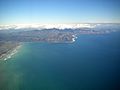
Aerial view of the eastern False Bay coast, looking somewhat south of east: Gordon's Bay (left) to Cape Hangklip (right)
-
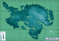
Bathymetry of the Whittle Rock reef
-
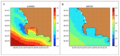
Charts of sea surface temperature in and near False Bay in summer and winter
-
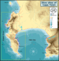
Map showing the distribution of most of the wreck and reef dive sites of the Cape Town local area


See also
 In Spanish: Bahía Falsa para niños
