
Regions of Western Australia facts for kids
Quick facts for kids Regions of Western Australia |
|
|---|---|
| Location | Western Australia |
| Number | 9, excluding the metropolitan region |
| Government | Regional councils, State government |
Western Australia (WA) is a very large state. To help manage it better, the state is divided into different areas called "regions." These regions are used for many reasons, like helping the economy grow, managing land, collecting information, and even for elections.
It's important to know that different systems define these regions. This means a region with the same name might have slightly different borders depending on which system is using it.
Contents
Regions for Economic Growth
The most common way Western Australia is divided into regions is by the Government of Western Australia. They use these regions to help local economies grow. There are nine main regions, not counting the big city area of Perth.
These nine regions were officially created by a law called the Regional Development Commissions Act 1993. This law set up special groups called Regional Development Commissions. Their job is to help each region's economy get stronger. When these regions were first planned, people tried to group areas that had similar ways of life and economies. For example, the Goldfields–Esperance region mostly focuses on mining. On the other hand, the Wheatbelt region relies heavily on farming.
| Region | Largest city | Number of LGAs |
Land area | Map | Ref. |
|---|---|---|---|---|---|
| Gascoyne | Carnarvon | 4 | 137,938 km2 (53,258.16 sq mi) |  |
|
| Goldfields–Esperance | Kalgoorlie | 10 | 955,276 km2 (368,834.13 sq mi) |  |
|
| Great Southern | Albany | 11 | 39,007 km2 (15,060.69 sq mi) |  |
|
| Kimberley | Broome | 4 | 424,517 km2 (163,906.93 sq mi) |  |
|
| Mid West | Geraldton | 16 | 285,497 km2 (110,231.01 sq mi) |  |
|
| Peel | Mandurah | 5 | 6,648 km2 (2,566.81 sq mi) |  |
|
| Pilbara | Karratha | 4 | 507,896 km2 (196,099.74 sq mi) |  |
|
| South West | Bunbury | 12 | 24,000 km2 (9,266.45 sq mi) |  |
|
| Wheatbelt | Northam | 42 | 154,862 km2 (59,792.55 sq mi) |  |
Travel Rules During the COVID-19 Pandemic

During the COVID-19 pandemic, the Western Australian government put rules on travel. People could not travel between most regions. Police set up checkpoints at the borders of these regions. Only very important travel was allowed. Sometimes, the police got help from the army and the State Emergency Service.
Some remote communities and special "biosecurity areas" had even stricter travel rules. This was because they had fewer medical facilities. Also, many people there were at higher risk. Some of these travel rules were lifted on May 18. By June 5, almost all regional travel rules were removed. Only remote Aboriginal communities still had some restrictions.
On January 31, 2021, a five-day lockdown was announced. This happened after a security guard in Perth tested positive for COVID-19. The lockdown lasted from January 31 to February 5. Schools that were supposed to open on February 1 stayed closed for another week. The lockdown affected the entire Perth metropolitan area, the Peel region, and the South West region.
Weather Forecast Regions
The Bureau of Meteorology (BOM) also divides Western Australia into regions. They use 14 regions for weather forecasts. Some of these regions have similar names to the economic development regions. However, their borders are not exactly the same. For some areas, the BOM gives even more detailed forecasts. They use directions like "North East Interior." Coastal areas have separate forecasts for sea conditions.
| BOM map number |
BOM region name |
Economic region name |
BOM overlap areas | Economic overlap areas | Notes |
|---|---|---|---|---|---|
| 01 | Kimberley | Kimberley | South East Kimberley in BOM "NE Interior" | close fit | |
| 02 | Pilbara | Pilbara | BOM North Interior in RDCA "East Pilbara" | ||
| 03 | Gascoyne | Gascoyne | BOM South and East Gascoyne in RDCA "Mid West" | ||
| 04 | Goldfields | Goldfields–Esperance | |||
| 05 | Eucla | Goldfields–Esperance | |||
| 06 | Northern Interior | ||||
| 07 | Southern Interior | Mid West | |||
| 08 | Central West | Perth, Peel | |||
| 09 | Lower West | South West | |||
| 10 | South West | Great Southern | |||
| 11 | South Coastal | Goldfields–Esperance | |||
| 11 | South East Coastal | Goldfields–Esperance | |||
| 13 | Great Southern | Great Southern | |||
| 14 | Central Wheat Belt | Wheatbelt |
Natural and Land Management Regions
Scientists and land managers also divide Western Australia into regions. These divisions are based on natural features. For example, they look at the types of plants and animals that live there. They also consider things like river systems, geology (the study of rocks and earth), and soil types.
Some well-known natural regions include the Interim Biogeographic Regionalisation for Australia (IBRA) regions. The World Wildlife Fund also has its own Ecoregions in Australia. These help us understand the different natural environments across the state.
Land Ownership Divisions
Western Australia is also divided into about 90 "land districts." These are used for keeping records of land ownership. There are five larger "land divisions" in Western Australia. These are listed in a law called the Land Administration Act 1997.
- Eastern Land Division
- Eucla Land Division
- Kimberley Land Division
- North-West Land Division
- South-West Land Division
Wine Regions
Western Australia is known for its wines. Most of the places where wine is made are in the very south-western part of the state. There are nine main wine regions. Some of these also have smaller "subregions." These regions are officially recognized under Australian wine laws.
Some of the wine regions include:
- Greater Perth
- South Western Australia
- Blackwood Valley
- Geographe
- Great Southern
- Albany
- Denmark
- Frankland River
- Mount Barker
- Porongurup
- Manjimup
- Margaret River
- Pemberton
Coastal Regions
Western Australia has the longest coastline of any state in Australia. It stretches for over 10,000 kilometers! The coast is divided into regions based on its geology (the types of rocks and landforms). The Bureau of Meteorology also uses coastal features like points and capes for its sea forecasts.
Some popular coastal regions for tourists include:
- Batavia Coast (around Dongara, Geraldton, and Kalbarri)
- Gascoyne Coast (includes Carnarvon, Coral Bay, Denham, Exmouth)
- Coral Coast (part of the Gascoyne Coast)
- Turquoise Coast (between the Sunset Coast and Batavia Coast)
- Sunset Coast (the beach suburbs of Perth, from Cottesloe to Yanchep)
Census and Statistics Regions
The Australian Bureau of Statistics (ABS) collects information about people and places. For this, they divide Western Australia into regions in a special way. It's like a set of nesting dolls:
- Statistical divisions
- Statistical subdivisions
- Statistical local areas
- Census collection districts (the smallest areas)
Some of the main statistical divisions are:
- SD 505 – Perth
- SD 510 – South West
- SD 515 – Lower Great Southern
- SD 520 – Upper Great Southern
- SD 525 – Midlands
- SD 530 – South Eastern
- SD 535 – Central
- SD 540 – Pilbara
- SD 545 – Kimberley
The ABS creates reports about these regions.
Other Ways to Group Regions
Sometimes, people group several regions together to describe a larger area.
- Remote Western Australia or Outback Western Australia means areas far from the main city of Perth. These areas have very few people living in them.
- North West Australia is a general term for the northern and western parts of the state.
- Southwest Australia refers to the southwestern part of the state.
- Nullarbor is a term that can mean different things. It generally covers parts of southeastern Western Australia and western South Australia.
Images for kids
-
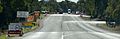
A checkpoint in Chittering in May 2020.
See also
 In Spanish: Regiones de Australia Occidental para niños
