
Kalgoorlie facts for kids
Quick facts for kids Kalgoorlie–BoulderWestern Australia |
|||||||||
|---|---|---|---|---|---|---|---|---|---|
 Kalgoorlie Court House and Post Office
|
|||||||||

Kalgoorlie–Boulder
Location in Western Australia
|
|||||||||
| Population | 29,068 (2021 census – UCL) | ||||||||
| • Density | 387.06/km2 (1,002.5/sq mi) | ||||||||
| Established | 1893 | ||||||||
| Elevation | 383 m (1,257 ft) | ||||||||
| Area | 75.1 km2 (29.0 sq mi)(2011 urban) | ||||||||
| Time zone | AWST (UTC+8) | ||||||||
| Location | |||||||||
| LGA(s) | City of Kalgoorlie–Boulder | ||||||||
| State electorate(s) | Kalgoorlie | ||||||||
| Federal Division(s) | O'Connor | ||||||||
|
|||||||||
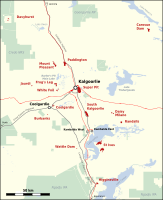
Kalgoorlie is a city in Western Australia. It is about 595 kilometres (370 miles) east of Perth. People often call it Kalgoorlie–Boulder because it includes the old town of Boulder. The city is in the Goldfields–Esperance region.
Kalgoorlie–Boulder is on the traditional lands of the Wangkatja people. The name "Kalgoorlie" comes from the Wangai word Karlkurla. This word means "place of the silky pears". The city started in 1893 during the Western Australian gold rushes. It quickly became the biggest town in the Eastern Goldfields. Kalgoorlie is also known for the Super Pit gold mine, which was Australia's largest open-cut gold mine for many years.
Contents
History of Kalgoorlie–Boulder


Kalgoorlie–Boulder is on the traditional lands of the Wangkatja people. Their languages, like Wangkatja, are still spoken there today.
In 1893, three gold prospectors were traveling. They were Patrick (Paddy) Hannan, Tom Flanagan, and Dan Shea. One of their horses lost a shoe, so they had to stop. While they waited, they saw signs of gold nearby. This was at the base of what is now the Mount Charlotte gold mine.
They decided to explore the area. On June 17, 1893, Hannan officially claimed the gold. This made hundreds of people rush to the area. They all wanted to find gold. This is how Kalgoorlie, first called Hannan's Find, began.

Gold mining has been a big industry in Kalgoorlie ever since. Other metals like nickel are also mined. Mining employs about a quarter of Kalgoorlie's workers. It brings in a lot of money for the city. The area with many large gold mines is called the Golden Mile. It was once known as the world's richest square mile of earth.
In 1896, a narrow-gauge railway line reached Kalgoorlie. This connected the city to Perth. Later, in 1917, a railway line was finished. It connected Kalgoorlie to Port Augusta in South Australia. This linked Kalgoorlie to the eastern states of Australia. In 1968, the railway to Perth was updated. This made it possible to travel by train from Perth all the way to Sydney. The Indian Pacific train service started soon after.
Kalgoorlie is famous for its water pipeline. C. Y. O'Connor designed this pipeline. It brings fresh water from Mundaring Weir near Perth. The city also has the Super Pit and the Mount Charlotte lookout. Its main street is Hannan Street, named after the city's founder.
In 1989, the Town of Kalgoorlie and the Shire of Boulder joined together. They formed the City of Kalgoorlie–Boulder. This made it the fifth largest city in Western Australia.
On April 20, 2010, an earthquake shook Kalgoorlie. It was a 5.0 on the Richter scale. The earthquake caused damage to some buildings in Boulder. Work in the Super Pit and other mines stopped for a short time.

People in Kalgoorlie–Boulder

In 2016, about 29,873 people lived in the Kalgoorlie–Boulder area.
- About 7.3% of the people were Aboriginal and Torres Strait Islander.
- Most people (65.8%) were born in Australia.
- Other people came from New Zealand (7.9%), England (2.4%), and the Philippines (2.2%).
- About 78.6% of people spoke only English at home.
- Other languages spoken included Afrikaans (1.3%) and Tagalog (1.1%).
- The most common religions were No Religion (33.4%) and Catholic (22.1%).
Kalgoorlie–Boulder's Climate
Kalgoorlie has a semi-arid climate. This means it has hot summers and mild winters. On average, it rains about 260 millimetres (10 inches) per year. This rain falls over about 68 days. The amount of rain can change a lot from year to year.
January is the hottest month. The average high temperature is 33.6°C (92.5°F). Temperatures can go above 40°C (104°F) almost every week. This happens when hot, dry winds blow from the north. Cooler weather often follows these hot days, sometimes with thunderstorms.
Winters are cool. In July, the average high is 16.7°C (62.1°F) and the average low is 5.0°C (41.0°F). Cold, wet days with temperatures below 12°C (53.6°F) happen about once each winter. Overnight temperatures can drop below freezing about four times in a typical winter.
| Climate data for Kalgoorlie | |||||||||||||
|---|---|---|---|---|---|---|---|---|---|---|---|---|---|
| Month | Jan | Feb | Mar | Apr | May | Jun | Jul | Aug | Sep | Oct | Nov | Dec | Year |
| Record high °C (°F) | 46.5 (115.7) |
44.9 (112.8) |
44.5 (112.1) |
40.1 (104.2) |
33.4 (92.1) |
27.6 (81.7) |
28.7 (83.7) |
32.0 (89.6) |
36.8 (98.2) |
40.9 (105.6) |
42.9 (109.2) |
45.0 (113.0) |
46.5 (115.7) |
| Mean daily maximum °C (°F) | 33.6 (92.5) |
32.1 (89.8) |
29.5 (85.1) |
25.3 (77.5) |
20.6 (69.1) |
17.5 (63.5) |
16.7 (62.1) |
18.6 (65.5) |
22.3 (72.1) |
25.8 (78.4) |
28.9 (84.0) |
31.9 (89.4) |
25.2 (77.4) |
| Mean daily minimum °C (°F) | 18.2 (64.8) |
17.8 (64.0) |
16.0 (60.8) |
12.8 (55.0) |
8.7 (47.7) |
6.2 (43.2) |
5.0 (41.0) |
5.5 (41.9) |
8.0 (46.4) |
11.0 (51.8) |
14.0 (57.2) |
16.5 (61.7) |
11.6 (52.9) |
| Record low °C (°F) | 8.8 (47.8) |
8.5 (47.3) |
5.7 (42.3) |
1.7 (35.1) |
−1.8 (28.8) |
−3.0 (26.6) |
−3.4 (25.9) |
−2.4 (27.7) |
−0.6 (30.9) |
−1.0 (30.2) |
3.1 (37.6) |
5.5 (41.9) |
−3.4 (25.9) |
| Average precipitation mm (inches) | 23.6 (0.93) |
31.2 (1.23) |
24.0 (0.94) |
20.0 (0.79) |
26.5 (1.04) |
28.9 (1.14) |
24.9 (0.98) |
21.4 (0.84) |
14.0 (0.55) |
14.8 (0.58) |
17.8 (0.70) |
16.4 (0.65) |
264.8 (10.43) |
| Average precipitation days (≥ 0.2mm) | 3.9 | 4.5 | 4.3 | 3.2 | 7.1 | 8.7 | 9.2 | 7.5 | 5.6 | 4.3 | 4.1 | 3.8 | 68.3 |
| Average afternoon relative humidity (%) | 24 | 30 | 32 | 38 | 44 | 48 | 46 | 39 | 31 | 27 | 25 | 24 | 34 |
| Average dew point °C (°F) | 8 (46) |
10 (50) |
9 (48) |
8 (46) |
6 (43) |
5 (41) |
4 (39) |
3 (37) |
3 (37) |
3 (37) |
5 (41) |
6 (43) |
6 (42) |
| Mean daily sunshine hours | 11.4 | 11.2 | 9.9 | 7.1 | 7.0 | 6.6 | 6.5 | 6.6 | 8.6 | 10.9 | 11.6 | 11.7 | 9.1 |
| Source 1: Bureau of Meteorology | |||||||||||||
| Source 2: Time and Date (dewpoints 1985-2015)
Weather Atlas (sun hours) |
|||||||||||||
Mining in Kalgoorlie–Boulder

Kalgoorlie–Boulder is an important regional centre. It has a Chamber of Commerce and a Chamber of Minerals and Energy.
Since 1992, Kalgoorlie has hosted the Diggers & Dealers conference. This big meeting happens every August. It is Australia's top international mining conference.
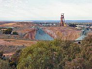
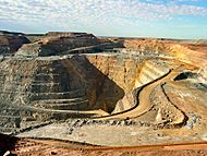
The Fimiston Open Pit, also called the Super Pit, is a huge open-cut gold mine. It is about 3.6 kilometres (2.2 miles) long. It is also 1.6 kilometres (1 mile) wide and over 600 metres (2,000 feet) deep. This mine used to be many smaller underground mines. In 1989, they were all combined into one big open pit.
There is a visitor centre where you can look over the mine. The mine works 24 hours a day, every day of the week. They blast rocks at 1:00 pm daily, unless the wind would blow dust over the town. Each giant truck carries 225 tonnes of rock. A round trip takes about 35 minutes. Most of that time is spent slowly driving uphill. The mine plans to keep working until 2035. They are also looking into making the mine even bigger.
-
Gold mines in the Kalgoorlie region.
-
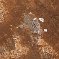
The Super Pit is in the middle of this picture.


Culture and Sports
.jpg)
Kalgoorlie–Boulder has a lively and varied cultural scene.
Sports in Kalgoorlie
Many people in Kalgoorlie–Boulder play sports. Popular sports include Australian rules football, netball, basketball, rugby league, soccer, field hockey, and cricket. Other sports like tennis, lawn bowls, and swimming are also enjoyed.
Kalgoorlie also hosts an international squash tournament each year at the YMCA. The Goldfields Giants basketball team plays in the State Basketball League. They won the league championship in 2007 and 2008. The Goldfields Titans play in the state rugby league competition. Their home games are at the Oasis playing fields.
Horse racing is very popular in the city. Kalgoorlie–Boulder has an internationally known annual "Race Round." The annual Kalgoorlie Desert Race is also held here. It is a very tough off-road race.
Attractions in Kalgoorlie

Kalgoorlie has many beautiful old buildings. These buildings show the city's rich past. Kalgoorlie–Boulder is the biggest town for hundreds of kilometres. It is the centre of social life for the area.
A special place to visit is the Kalgoorlie–Boulder Racecourse, where horse races are held. There are also two grass sports ovals and a cinema.
.jpg)

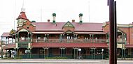
Historic Hotels
Kalgoorlie has several historic hotels that are still open today:
- Broken Hill Hotel – a well-known place in Boulder.
- Exchange Hotel, Kalgoorlie – located at Kalgoorlie's main intersection.
- Kalgoorlie Hotel – across from the Kalgoorlie town hall.
- Palace Hotel – also at Kalgoorlie's main intersection.
- Piccadilly Hotel – a local pub north of Kalgoorlie's city centre.
- Recreation Hotel – a two-story hotel in Boulder.
Suburbs of Kalgoorlie–Boulder
The Kalgoorlie–Boulder area has several suburbs:
- Boulder
Boulder is known as the home of the Super Pit. It is one of Kalgoorlie–Boulder's oldest suburbs. Many buildings here date back to 1882. It used to be the main business area for the Town of Boulder. Now, it is more of a historical local centre. Boulder has its own post office, town hall, and many hotels.
- Broadwood (also called Hampton Heights)
This is a new housing area. It is next to the Kalgoorlie–Boulder Airport. The airport was recently made bigger.
- Fairways
This area is named after a golf course that used to be here. It was built to offer affordable homes. Fairways has a private primary school, a church, a caravan park, and small businesses.
- Golden Grove (formerly Adeline)
Adeline was built around 1970. It was designed with houses facing away from the street. Common paths linked the homes. In 2003, the area was updated and renamed Golden Grove. Homes were also re-aligned.
- Hannans

Hannans is in the far north of Kalgoorlie. It was the first suburb to have its own shopping centre. This centre is called "Hannans Boulevard." It has a supermarket. The area also has a primary school and an 18-hole golf course. The golf course was recently updated. It is now a luxury desert golf course.
- Kalgoorlie
This is the central business district. Hannan Street is Kalgoorlie's main street. It runs through the whole suburb. The western part has houses and some light industry. The eastern part has shops, banks, the police station, and restaurants. It also has hotels, tourist spots, schools, and a university.
- Lamington
Lamington is one of Kalgoorlie's oldest suburbs. Most streets here run parallel to Hannan Street. The streets are very wide. It has North Kalgoorlie Primary School, small businesses, and a hotel.
- O'Connor
O'Connor is the south-east part of Somerville. It has a primary school and a private high school. There are also shopping areas. It is home to the city's only recreation centre.
- Piccadilly
This is a narrow suburb between Central Kalgoorlie and Lamington. It has the city's regional hospital. It also has small businesses, a hotel, and sports fields.
- Somerville
Somerville is where the Great Eastern Highway ends. This highway connects Kalgoorlie–Boulder and Perth. Somerville has homes, schools, shops, and some light industry.
- South Kalgoorlie
This suburb is mostly residential. It also has the Kalgoorlie–Boulder Racecourse and schools. Some light industry and small businesses are here too.
- West Kalgoorlie
This is Kalgoorlie's main industrial area. It is the first suburb you see when coming from Perth. It has the city's airport. It also has small, medium, and heavy industrial areas.
- Williamstown
This small area has mostly houses and one primary school. It is also home to the Mount Charlotte gold mine. This mine has produced about 5,000,000 ounces of gold. The Cassidy Shaft is also here.
Transport in Kalgoorlie
.jpg)
Train Services
The city is on the main East-West rail line across Australia. The Transwa Prospector train runs once or twice daily from Kalgoorlie to Perth. The Indian Pacific train also stops here. It runs weekly in both directions.
Bus Services
TransGoldfields provides bus services within the town. There are three town routes and school services. Transwa also runs long-distance buses that serve the town.
Air Travel
Commercial flights connect Kalgoorlie–Boulder with Melbourne and Perth. These flights use the Kalgoorlie–Boulder Airport. Airlines like Alliance Airlines, Qantas, and Virgin Australia fly here regularly. There is also a local company, Goldfields Air Services, that offers charter flights and a flight school.
Road Connections
Kalgoorlie is connected to Perth by the Great Eastern Highway. It is also on the Goldfields Highway.
Media in Kalgoorlie
Radio Stations
You can listen to these radio stations in Kalgoorlie:
- ABC Goldfields–Esperance: 6GF 648 AM / 94.3 FM
- ABC Classic FM: 6ABCFM 95.5 FM
- ABC Radio National: 6ABCRN 97.1 FM
- ABC Triple J: 6JJJ 93.5 FM / 98.7 FM
- ABC News: 6PNN 100.3 FM
- Hit 97.9 (Commercial Station) 6KAR: 91.9 / 97.9 FM – plays popular music.
- Triple M (Commercial Station) 6KG: 981 AM / 92.7 FM – plays adult contemporary and classic hits.
- Vision Radio Network 1431 AM: a Christian radio station.
- Tjuma Pulka (Media) Aboriginal Corporation: 96.3 FM (Aboriginal Community radio service).
- 6TAB Racing Radio – 88FM (broadcasts horse, greyhound, and harness racing).
Television Channels
Television services available include:
- The Australian Broadcasting Corporation (ABC) – ABC TV, ABC TV Plus/ABC Kids, ABC Me, ABC News.
- The Special Broadcasting Service (SBS) – SBS, SBS Viceland, SBS World Movies, SBS Food, NITV.
- Seven Network
- WIN Television, which shows programs from the Nine Network.
- West Digital Television, which shows programs from the Network 10.
The TV shows are mostly the same as in Perth. But there are some differences for news, sports like Australian Football League, and kids' shows. Seven has a newsroom in Kalgoorlie. They report on the area for their evening news program, Seven News.
You can also get Foxtel, a subscription TV service, via satellite.
Newspapers
The local newspaper for Kalgoorlie–Boulder is The Kalgoorlie Miner. You can also buy newspapers from Perth, like The West Australian. National newspapers like The Australian are also available.
Education in Kalgoorlie
Kalgoorlie–Boulder has 10 primary schools, four high schools, and one university.
Primary Schools
- Boulder Primary School
- East Kalgoorlie Primary School
- Goldfields Baptist College (private)
- Hannans Primary School
- Kalgoorlie Primary School
- Kalgoorlie School of the Air
- North Kalgoorlie Primary School
- O'Connor Primary School
- O'Connor Education Support Centre
- Saint Joseph's Primary School (private)
- Saint Mary's Primary School (Kalgoorlie Catholic Primary School) (private)
- South Kalgoorlie Primary School
High Schools
- Eastern Goldfields College
- Eastern Goldfields Education Support Centre
- John Paul College (private)
- Kalgoorlie–Boulder Community High School
- Goldfields Baptist College (Year K–10) (private)
Universities
- Curtin University of Technology – Kalgoorlie Campus. This includes the Western Australian School of Mines.
- University of Western Australia and University of Notre Dame Australia – Rural Clinical School of Western Australia [1].
Famous People from Kalgoorlie
Many notable people are from or have lived in Kalgoorlie. Here are a few:
- Kate Atkinson, an actress.
- Thomas Axford, a brave soldier who received the Victoria Cross in World War I.
- Matt Birney, a former political leader in Western Australia.
- John Bowler, an Australian politician.
- John Carroll, another brave soldier who received the Victoria Cross.
- John Cornell, an actor and movie producer.
- Rica Erickson, a historian and botanist.
- Dean Fiore, a V8 supercar driver.
- Sophie Garbin, a netball player for the Australian Diamonds.
- Eileen Joyce, a famous pianist.
- Dean Kemp, a former Australian rules footballer.
- Walter Lindrum, a champion billiards player.
- Barry Marshall, a Nobel Prize winner.
- Melissa Price, a politician.
- Tim Rogers, a singer and songwriter.
- Dom Sheed, an Australian rules footballer.
- Lydia Williams, an Australian soccer player.
Images for kids
-
Exchange Hotel.
-
Mt Charlotte Mine and Cassidy Shaft, Williamstown.
-
The Super Pit, Australia's largest open-cut gold mine until 2016.
-
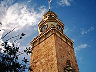
The Kalgoorlie Courthouse, previously the Post Office.
-
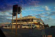
The Kalgoorlie Hotel/Judds Pub.


See also
 In Spanish: Kalgoorlie para niños
