City of Kalgoorlie–Boulder facts for kids
Quick facts for kids City of Kalgoorlie–BoulderWestern Australia |
|||||||||||||||
|---|---|---|---|---|---|---|---|---|---|---|---|---|---|---|---|

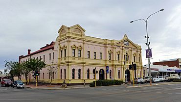
The Kalgoorlie Town Hall
|
|||||||||||||||

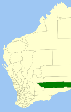
Location in Western Australia
|
|||||||||||||||
| Established | 1989 | ||||||||||||||
| Area | 95,575.1 km2 (36,901.8 sq mi) | ||||||||||||||
| Mayor | Glenn Wilson | ||||||||||||||
| Council seat | Kalgoorlie | ||||||||||||||
| Region | Goldfields–Esperance | ||||||||||||||
| State electorate(s) | Kalgoorlie | ||||||||||||||
| Federal Division(s) | O'Connor | ||||||||||||||
 |
|||||||||||||||
| Website | City of Kalgoorlie–Boulder | ||||||||||||||
|
|||||||||||||||
The City of Kalgoorlie–Boulder is a special area in Western Australia that has its own local government. It's located about 550 kilometers (340 miles) east of Perth, the state capital.
This city is huge! It covers an area of 95,575 square kilometers (36,902 square miles). That makes it one of the largest cities in the world by land area, even bigger than the country of Portugal. Most of the people living in the City of Kalgoorlie–Boulder live in the main towns of Kalgoorlie or Boulder.
Contents
History of Kalgoorlie–Boulder
This area has been home to Aboriginal Australians for a very long time. They lived and cared for this land for thousands of years.
How the City Was Formed
When gold was discovered here, many small towns and local governments started up. Over time, only a few lasted. Here are the main ones that eventually joined together:
- The Municipality of Kalgoorlie was created in 1895. It became the Town of Kalgoorlie in 1961.
- The Municipality of Boulder was formed in 1897. It became the Town of Boulder in 1961.
- The East Coolgardie Roads Board started in 1895. It was later called the Kalgoorlie Roads Board and then the Shire of Kalgoorlie in 1961.
These different local areas slowly came together. In July 1969, the Town of Boulder joined with the Shire of Kalgoorlie. This new combined area was then called the Shire of Boulder. Finally, on February 1, 1989, the Shire of Boulder and the Town of Kalgoorlie joined forces to create the City of Kalgoorlie–Boulder as we know it today.
Roads in Kalgoorlie–Boulder
The City of Kalgoorlie–Boulder has many important roads that help people get around. Some of the main roads within the city include:
- Boulder Road
- Anzac Drive
- Gatacre Drive
- Picadilly Street
- Hannan Street
- Graeme Street
- Maritana Street
- Federal Road
- Croesus St
Major Roads in the Region
Two very important highways connect Kalgoorlie–Boulder to other parts of Western Australia:
- Goldfields Highway
- Great Eastern Highway
How Kalgoorlie–Boulder is Governed
The City of Kalgoorlie–Boulder is managed by a group of twelve councillors. These councillors are elected by the people who live in the city. The mayor, who is the leader of the city, is also chosen by a public vote. This means everyone gets a say in who represents them!
Towns and Areas in Kalgoorlie–Boulder
The City of Kalgoorlie–Boulder is made up of many different towns, suburbs, and smaller areas. While Kalgoorlie and Boulder are the largest and most well-known, there are many other places within the city's boundaries. These include areas like Somerville, Hannans, and Lamington, each with its own community.
Ghost Towns in the City of Kalgoorlie–Boulder
A "ghost town" is a place that used to be a busy town but is now mostly empty. Many of these towns grew during the gold rush when people flocked to find gold. Once the gold ran out, people moved away, leaving the towns behind. Some ghost towns in the City of Kalgoorlie–Boulder include:
Heritage-Listed Places
The City of Kalgoorlie–Boulder has many buildings and sites that are considered important because of their history. These are called "heritage-listed places." As of 2023, there are 387 such places. Some of the most famous ones include the Kalgoorlie Railway Station, the historic York Hotel, the Exchange Hotel, and the Boulder railway station. These places help us remember the city's past.
 | Bayard Rustin |
 | Jeannette Carter |
 | Jeremiah A. Brown |


