Pemberton, Western Australia facts for kids
Quick facts for kids PembertonWestern Australia |
|||||||||||||||
|---|---|---|---|---|---|---|---|---|---|---|---|---|---|---|---|

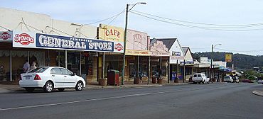
Pemberton main street.
|
|||||||||||||||
| Established | 1913 | ||||||||||||||
| Postcode(s) | 6260 | ||||||||||||||
| Elevation | 174 m (571 ft) | ||||||||||||||
| Area | [convert: needs a number] | ||||||||||||||
| Location | |||||||||||||||
| LGA(s) | Shire of Manjimup | ||||||||||||||
| State electorate(s) | Warren-Blackwood | ||||||||||||||
| Federal Division(s) | O'Connor | ||||||||||||||
|
|||||||||||||||
|
|||||||||||||||
Pemberton is a cool town in the South West part of Western Australia. It was named after an early settler, Pemberton Walcott.
Contents
History of Pemberton
Long ago, the land around Pemberton was home to the Noongar people, specifically the Bibbulmun group. They called this area "Wandergarup," which means 'plenty of water' in their language.
Early Settlers in the 1800s
In 1861, three explorers named Edward Reveley Brockman, Gerald de Courcy Lefroy, and Pemberton Walcott visited the area. The next year, in 1862, Brockman set up a large farm called Warren House near the Warren River.
Pemberton Walcott, who the town is named after, started his own farm called Karri Dale. This farm was just outside where Pemberton is today. Lefroy also built a farm and a flour mill. Walcott stayed in the area until at least 1867. Later, in 1872, his farm Karri Dale was put up for sale. It was described as having a brick cottage, farm buildings, a garden with fruit trees, and fresh running water.
Pemberton in the 1900s
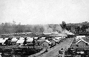
In 1913, a new government company called State Saw Mills started building two large sawmills. These mills were at a place then known as Big Brook. Their main job was to cut wood for half a million railway sleepers. These sleepers were needed for the Trans-Australian Railway, a huge train line across Australia.
The mills were built in a valley. This was a smart idea because it made it easy to roll logs downhill to the mills. It also ensured the mills had a steady supply of water. Big Brook quickly grew into a busy town just for the mill workers. It had a hall, a shop, homes for staff, cottages for workers, and places for single men to live.
People soon wanted a more unique name for the town. The name Walcott was suggested, but it was already used for Port Walcott. So, William Locke Brockman, a local farmer whose father was an early settler, suggested "Pemberton." The mill town was already well-known, but by 1921, people wanted it to be an official government town. Because of this, land lots were measured out in 1925, and Pemberton officially became a town in October 1925.
After the Second World War, more people moved to the area to start farms. This helped the town grow. In the 1980s, Pemberton started to become popular with tourists. Today, tourism is still a very important part of the town's economy.
Pemberton Today: The 2000s
In 2005, cutting and processing timber was still the biggest industry in Pemberton. However, the government reduced logging of old forests in 2003. Instead of closing, the mill started using wood from special tree farms. They now use Tasmanian blue gum and pine trees, as well as the native karri wood.
Growing grapes for wine, called Viticulture, has also become very popular. Many companies have bought large areas of farmland to turn them into vineyards.
Fun Things to Do in Pemberton
Pemberton is a great place for adventures and exploring nature!
Climbable Trees
Close to Pemberton, you can find two giant karri trees that you can actually climb! They are both over 60 metres (about 200 feet) tall.
- The most famous is the Gloucester Tree.
- There is also the Dave Evans Bicentennial Tree, which is even taller at about 71 metres (233 feet).
These trees have metal rungs, like a ladder, that let visitors climb up to a lookout platform at the very top. It's an amazing view!
The Diamond Tree used to be climbable too, but it was closed for climbing in 2019.
Other Attractions and Activities
Pemberton has many other exciting things to see and do:
- The Pemberton Tramway Company offers fun rides on an old tram.
- Explore the huge Yeagarup Dunes.
- Walk part of the Bibbulmun Track, a very long walking trail.
- You can also go on river cruises, hiking trips, canoeing adventures, and four-wheel drive tours through the national parks.
Festivals and Local Products
Every May, Pemberton hosts the Southern Forests Festival. This festival celebrates the region's delicious food and wine. Pemberton is known as one of Australia's best places for cool-climate wines, so there are many wineries to visit.
Exploring the Karri Forest
Pemberton is surrounded by beautiful karri forests. There are five national parks within a short drive! The area also has many rivers, streams, and dams perfect for outdoor fun. The Karri Forest Explorer Drive is a special route that connects all the main tourist spots.
- Big Brook Dam: This dam is in the Pemberton State Forest, about 6 km north. It's a great spot for bird watching, picnics, and swimming at the sandy beach. There's also a 4 km paved walking trail around the lake.
- Beedelup Falls: These pretty waterfalls are about 30 km north in the Beedelup National Park. You can explore them by walking across a cool suspension bridge.
- Yeagarup Dunes: Located in the D'Entrecasteaux National Park, these are the biggest inland sand dunes in the southern part of the world! They are slowly moving towards Yeagarup Lake. You can take special 4WD tours to see them up close.
- Lake Jasper: Also in the D’Entrecasteaux National Park, this is a natural freshwater lake. It's about 10 metres deep and can only be reached by 4WD vehicles.
- Black Point: This spot has amazing black Basalt rock columns that were formed about 135 million years ago! You can join local tours to visit this unique place.
- The Cascades: These are a series of small waterfalls in Lefroy Brook. You can drive there, or even take the historic Tram from Pemberton, which runs twice a day.
Pemberton's Climate
Pemberton has a Mediterranean climate. This means it has warm, dry summers and cool, rainy winters. It's a bit like the weather you'd find around the Mediterranean Sea!
| Climate data for Pemberton, Western Australia | |||||||||||||
|---|---|---|---|---|---|---|---|---|---|---|---|---|---|
| Month | Jan | Feb | Mar | Apr | May | Jun | Jul | Aug | Sep | Oct | Nov | Dec | Year |
| Record high °C (°F) | 43.2 (109.8) |
41.7 (107.1) |
40.0 (104.0) |
33.8 (92.8) |
28.5 (83.3) |
23.2 (73.8) |
22.0 (71.6) |
25.4 (77.7) |
28.4 (83.1) |
33.6 (92.5) |
38.0 (100.4) |
40.4 (104.7) |
43.2 (109.8) |
| Mean daily maximum °C (°F) | 26.2 (79.2) |
26.5 (79.7) |
24.6 (76.3) |
21.3 (70.3) |
18.2 (64.8) |
16.0 (60.8) |
15.1 (59.2) |
15.6 (60.1) |
16.8 (62.2) |
18.9 (66.0) |
21.5 (70.7) |
24.1 (75.4) |
20.4 (68.7) |
| Mean daily minimum °C (°F) | 13.2 (55.8) |
13.6 (56.5) |
12.8 (55.0) |
11.0 (51.8) |
9.3 (48.7) |
8.1 (46.6) |
7.2 (45.0) |
7.1 (44.8) |
7.6 (45.7) |
8.7 (47.7) |
10.3 (50.5) |
11.9 (53.4) |
10.1 (50.2) |
| Record low °C (°F) | 4.0 (39.2) |
5.6 (42.1) |
3.9 (39.0) |
−0.8 (30.6) |
2.0 (35.6) |
−0.4 (31.3) |
0.0 (32.0) |
0.0 (32.0) |
0.4 (32.7) |
0.6 (33.1) |
2.5 (36.5) |
4.4 (39.9) |
−0.8 (30.6) |
| Average precipitation mm (inches) | 23.0 (0.91) |
19.5 (0.77) |
36.8 (1.45) |
73.4 (2.89) |
149.7 (5.89) |
187.2 (7.37) |
211.2 (8.31) |
170.5 (6.71) |
129.6 (5.10) |
88.8 (3.50) |
59.8 (2.35) |
35.3 (1.39) |
1,184.2 (46.62) |
| Average precipitation days | 7.1 | 6.8 | 9.3 | 13.6 | 18.3 | 21.1 | 22.9 | 22.3 | 19.0 | 16.4 | 12.4 | 9.7 | 178.9 |
| Mean monthly sunshine hours | 282.1 | 245.8 | 229.4 | 180.0 | 145.7 | 123.0 | 127.1 | 151.9 | 159.0 | 217.0 | 219.0 | 260.4 | 2,340.4 |
| Source: The Bureau of Meteorology | |||||||||||||
 | Shirley Ann Jackson |
 | Garett Morgan |
 | J. Ernest Wilkins Jr. |
 | Elijah McCoy |


