Carnarvon, Western Australia facts for kids
Quick facts for kids CarnarvonWestern Australia |
|||||||||
|---|---|---|---|---|---|---|---|---|---|

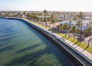
The Carnarvon Fascine boardwalk
|
|||||||||
| Population | 4,879 (2021 census) | ||||||||
| Established | 1883 | ||||||||
| Postcode(s) | 6701 | ||||||||
| Elevation | 4 m (13 ft) | ||||||||
| Location | |||||||||
| LGA(s) | Shire of Carnarvon | ||||||||
| State electorate(s) | North West Central | ||||||||
| Federal Division(s) | Durack | ||||||||
|
|||||||||
Carnarvon (/kərˈnɑːrvən/ kər-NAR-vən) is a coastal town in Western Australia. It is about 900 kilometers (560 miles) north of Perth. The town sits where the Gascoyne River meets the Indian Ocean.
To the south of Carnarvon, you'll find the famous Shark Bay World Heritage Site. North of the town are the beautiful Ningaloo Reef and the popular tourist town of Exmouth. In 2021, Carnarvon had a population of 4,879 people.
Contents
History of Carnarvon
The Inggarda people are the original traditional owners of the land around Carnarvon. Before Europeans arrived, this area was called Kuwinywardu. This name means "neck of water" in the local language. Indigenous Australians from this area are often known as Yamatji people. They traditionally speak the Wajarri language.
The town of Carnarvon was started in 1883. It was first used as a port and a place to get supplies for the nearby areas. Today, it is the main administrative center for the Shire of Carnarvon. The town was officially named on June 4, 1891. It was named after Henry Herbert, 4th Earl of Carnarvon, who was a British government official.
Carnarvon Jetty
The Carnarvon Jetty was built in the late 1890s. It reached its full length in 1904. This long pier was an important part of the town's port. Sadly, in 2021, the jetty was badly damaged by Cyclone Seroja.
Carnarvon Tramways
Carnarvon has had three different tramways over the years. A tramway is like a small railway, often used for moving goods.
- The first tramway was very short. It was built in 1884 and ran from a river landing to a shed. People used a lever to power the trolley, and sometimes even wind power!
- The second tramway was built between 1886 and 1887. It ran from the town towards the jetty and was pulled by horses.
- The third tramway was finished in 1900. This one ran from the town across Babbage Island to the deep-sea jetty. It was about 3.3 kilometers (2 miles) long. At first, it was a very light railway. Because heavy loads of wool were carried, it was made stronger in 1908–09. A steam locomotive then pulled the trains. This tramway stopped working in December 1965. Like the jetty, parts of this tramway were also damaged by Cyclone Seroja in 2021.
Aerospace History
Carnarvon has a cool connection to space! From 1964 to 1965, 12 sounding rockets were launched from here. These rockets went up to 120 kilometers (75 miles) high.
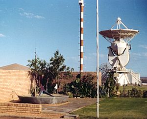
In the 1960s, NASA (the American space agency) built a tracking station near the town. This station helped support the Gemini and Apollo space programs. It was important for communicating with spacecraft. The tracking station closed in the mid-1970s. Today, only the foundations of the old site remain.
The Korean Star Ship
On May 20, 1988, a large ship called the Korean Star got stuck near Carnarvon. This happened during bad weather. About 600 tonnes (660 tons) of fuel oil spilled into the ocean. Luckily, the damage was mostly limited to about 10 kilometers (6 miles) of remote beaches. The ship was not removed and was left grounded. Today, very little of the wreck can still be seen.
Carnarvon's Economy
The main ways people make a living in the Carnarvon area are:
- Mining: There is a salt mine at nearby Lake Macleod. There are also other mines inland.
- Fishing: A big part of the fishing industry here is catching prawns.
- Tourism: Many visitors come to see the beautiful coastal areas and attractions.
- Agriculture: This is a major industry. Farmers grow many products along the Gascoyne River. They grow bananas, tomatoes, grapefruit, mangoes, and table grapes. Carnarvon's climate helps growers produce these foods when they are not in season elsewhere. This means they can sell them locally and to other countries. Farmers also raise cattle, goats, and sheep for wool.
Education in Carnarvon
Carnarvon has five schools for students. These include:
- St Mary's Star of the Sea Catholic School, which opened in 1906.
- Carnarvon Community College (which used to be three separate schools).
- Carnarvon School of the Air, which teaches students in remote areas using radio and online tools.
- Carnarvon Christian School.
Carnarvon's Climate
Carnarvon has a warm, dry climate (BWh). The average rainfall each year is about 226 millimeters (8.9 inches). Most of the rain falls between May and July. This happens when the edges of winter cold fronts reach the region.
Sometimes, tropical cyclones hit Carnarvon in the summer. These storms bring heavy rain and strong winds. Other than these storms, summers are usually dry. Temperatures usually range from an average high of 33°C (91°F) in February to 22°C (72°F) in July. The average low temperatures are 23°C (73°F) and 11°C (52°F) in those months. On February 18, 2024, Carnarvon had its hottest day ever, reaching 49.9°C (121.8°F). The town is very sunny, with over 200 clear days each year.
| Month | Jan | Feb | Mar | Apr | May | Jun | Jul | Aug | Sep | Oct | Nov | Dec | Year |
|---|---|---|---|---|---|---|---|---|---|---|---|---|---|
| Record high °C (°F) | 47.8 (118.0) |
49.9 (121.8) |
47.8 (118.0) |
41.1 (106.0) |
37.1 (98.8) |
32.2 (90.0) |
32.5 (90.5) |
33.6 (92.5) |
38.8 (101.8) |
43.9 (111.0) |
43.4 (110.1) |
45.6 (114.1) |
49.9 (121.8) |
| Mean daily maximum °C (°F) | 31.7 (89.1) |
32.5 (90.5) |
32.1 (89.8) |
29.8 (85.6) |
27.1 (80.8) |
24.0 (75.2) |
23.1 (73.6) |
23.8 (74.8) |
24.8 (76.6) |
26.6 (79.9) |
28.4 (83.1) |
30.1 (86.2) |
27.8 (82.0) |
| Mean daily minimum °C (°F) | 22.8 (73.0) |
23.6 (74.5) |
22.4 (72.3) |
19.4 (66.9) |
14.8 (58.6) |
12.0 (53.6) |
10.8 (51.4) |
11.6 (52.9) |
13.9 (57.0) |
16.7 (62.1) |
19.0 (66.2) |
21.1 (70.0) |
17.3 (63.1) |
| Record low °C (°F) | 15.9 (60.6) |
15.6 (60.1) |
13.2 (55.8) |
8.9 (48.0) |
6.1 (43.0) |
3.6 (38.5) |
2.4 (36.3) |
3.4 (38.1) |
5.9 (42.6) |
8.1 (46.6) |
10.7 (51.3) |
14.0 (57.2) |
2.4 (36.3) |
| Average precipitation mm (inches) | 7.9 (0.31) |
17.2 (0.68) |
19.1 (0.75) |
15.4 (0.61) |
23.8 (0.94) |
42.5 (1.67) |
42.7 (1.68) |
15.9 (0.63) |
7.6 (0.30) |
3.0 (0.12) |
2.6 (0.10) |
12.7 (0.50) |
210.0 (8.27) |
| Average precipitation days (≥ 1 mm) | 1.2 | 1.6 | 1.3 | 1.4 | 2.4 | 4.9 | 3.8 | 2.9 | 1.7 | 0.8 | 0.6 | 0.4 | 23.0 |
| Average relative humidity (%) (at 15:00) | 57 | 58 | 55 | 55 | 51 | 49 | 50 | 48 | 50 | 50 | 52 | 55 | 53 |
| Average dew point °C (°F) | 20 (68) |
21 (70) |
18 (64) |
16 (61) |
11 (52) |
10 (50) |
9 (48) |
10 (50) |
11 (52) |
14 (57) |
15 (59) |
17 (63) |
14 (58) |
| Mean daily sunshine hours | 11.6 | 9.7 | 9.6 | 9.2 | 7.3 | 6.9 | 7.1 | 9.3 | 9.7 | 11.3 | 11.7 | 11.8 | 9.6 |
| Source 1: Bureau of Meteorology: Carnarvon Airport | |||||||||||||
| Source 2: Time and Date (dewpoints 2005–2015)
Weather Atlas (sun hours) Perth Now |
|||||||||||||
Notable People from Carnarvon
Many interesting people have connections to Carnarvon:
- Andrew Broad, an Australian politician.
- Troy Cook, an Australian rules footballer who played for the Sydney Swans and Fremantle Dockers.
- Craig Fong, an actor.
- Shelley Gare, a journalist and author.
- Daniel Johnson, a basketball player for the Melbourne Tigers and Adelaide 36ers.
- Michael Mitchell, an Australian rules footballer for the Richmond Tigers.
- Keith Murdoch, a New Zealand rugby union player for the All Blacks. He spent his later years in Carnarvon.
- Cleo Smith, a young girl who was found safe after going missing in 2021.
- Tom Vandeleur, an Australian rules footballer who was a rookie for the Fremantle Dockers.
- Jay Watson, an Australian musician who plays in the bands Tame Impala and Pond.
See also
 In Spanish: Carnarvon para niños
 | Jessica Watkins |
 | Robert Henry Lawrence Jr. |
 | Mae Jemison |
 | Sian Proctor |
 | Guion Bluford |


