
Gascoyne River facts for kids
Quick facts for kids Gascoyne |
|
|---|---|

The Gascoyne riverbed near Carnarvon
|
|
| Country | Australia |
| State | Western Australia |
| Region | Gascoyne |
| City | Carnarvon |
| Physical characteristics | |
| Main source | Collier Range Three Rivers Station 514 m (1,686 ft) 24°39′8″S 119°44′58″E / 24.65222°S 119.74944°E |
| 2nd source | Gascoyne River (Middle) west of Beyondie Lakes 25°20′42″S 119°38′53″E / 25.34500°S 119.64806°E |
| 3rd source | Gascoyne River (South) near the Doolgunna homestead 25°41′45″S 119°13′17″E / 25.69583°S 119.22139°E |
| River mouth | Indian Ocean Shark Bay 0 m (0 ft) 24°52′14″S 113°36′57″E / 24.87056°S 113.61583°E |
| Length | 865 km (537 mi) |
| Basin features | |
| Basin size | 76,254 km2 (29,442 sq mi) |
| Tributaries |
|
| Natural pools | Tibingoona Pool; Bibbingoona Pool; Nungamarra Pool; Mibbley Pool; Mutherbukin Pool; Beelu Pool; Bilyarra Pool; Piddendoora Pool; and Gnardune Pool |


The Gascoyne River is a long river in the Gascoyne region of Western Australia. It stretches for about 865 kilometres (537 mi). This makes it the longest river in Western Australia.
Contents
About the Gascoyne River
The Gascoyne River starts from three main branches high up. The North Branch begins in the Collier Range. It flows from Three Rivers Station, about 100 kilometres (62 mi) northeast of Peak Hill. This branch flows for about 125 kilometres (78 mi).
The Middle Branch starts west of Beyondie Lakes, near Kumarina. It flows for about 15 kilometres (9.3 mi). The South Branch begins near the Doolgunna homestead. It also flows for about 15 kilometres (9.3 mi).
The Gascoyne River generally flows west and southwest. It is joined by 36 smaller rivers and creeks. These include the Lyons River, Landor River, and Thomas River. The Gascoyne and Lyons rivers together drain a huge area of 68,326 square kilometres (26,381 sq mi). This area is east of the Kennedy Ranges. It reaches about 480 kilometres (300 mi) inland.
The river ends by flowing into Shark Bay and the Indian Ocean at Carnarvon. From its start to its end, the river drops 514 metres (1,686 ft) over its 865 kilometres (537 mi) path.
An "Upside-Down" River
The Gascoyne River is often called an upside-down river. This is because it only flows above ground for about 120 days each year. For the rest of the year, the river flows underground. It moves beneath the dry riverbed.
This means the river acts like a giant underground water storage system. Its water is held in aquifers, which are layers of rock or sand that can hold water. These aquifers are hidden below the desert sands.
The river flows through areas with not many plants. This land is mainly used for gold-mining and sheep farms. The river has many permanent pools of water. These pools are very important for both farm animals and local wildlife. Some of the main pools are Tibbingoona Pool, Mutherbokin Pool, and Mibbley Pool.
History of the Gascoyne River
Aboriginal peoples have known about the Gascoyne River for thousands of years. They have lived in the area for a very long time.
Europeans first saw the river on March 4, 1839. It was discovered by an explorer named Lieutenant George Grey. He named the river after his friend, Captain John Gascoyne RN. Captain Gascoyne was a member of the Royal Navy. He was also involved in groups that supported the colony of Western Australia.
The area faced a very dry period from mid-1909 to early 1913. During this time, the Gascoyne River did not flow at all. This caused problems with water supply in the town of Carnarvon.
Major Floods
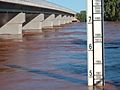
The Gascoyne River has experienced several big floods. The most serious flood happened in December 2010. This flood was caused by a huge amount of rain. In just four days, the area received over 6,000 percent more rain than usual for that month.
Water levels in the river reached record highs. Near Fishy Pool, the water rose to 15.53 metres (51.0 ft). People in several towns had to leave their homes because of the rising water. Carnarvon was hit the hardest, with some houses being washed away.
After the flood, emergency supplies and money were sent to help people. This helped them rebuild their lives. No people died in the flood. However, about two thousand cattle were lost. The damage was estimated to be around A$100 million. This large flood caused many serious problems for the region.
In March 2015, Cyclone Olwyn also caused flooding in the Gascoyne River. This was the most severe flood since the one in 2010.
Images for kids
-

Rocky Pool – Gascoyne River.
-
Gascoyne River in flood, April 2006.
-
Dry Gascoyne riverbed.


