Kumarina, Western Australia facts for kids
Quick facts for kids KumarinaWestern Australia |
|
|---|---|

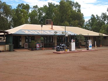
Kumarina Roadhouse, 2011
|
|
| Postcode(s) | 6642 |
| Elevation | 610 m (2,001 ft) |
| Area | [convert: needs a number] |
| Location |
|
| LGA(s) | Shire of Meekatharra |
| State electorate(s) | North West |
| Federal Division(s) | Durack |
Kumarina is a small place in the Mid West region of Western Australia. It sits right on the Great Northern Highway, which is a very long road. This road connects the towns of Meekatharra and Newman.
Kumarina is also the closest settlement to Collier Range National Park. This park is a special natural area.
About Kumarina
Kumarina is a handy stop for people traveling through Western Australia. It offers several services for visitors. These services make it a useful place to rest and refuel.
What You Can Find There
Kumarina has a few important buildings and services. These include a roadhouse, which is like a service station with food. There is also a caravan park where people can stay in their caravans or tents.
You can also find a small wildlife sanctuary in Kumarina. This sanctuary helps protect local animals. There is also a tavern, a motel for overnight stays, and a restaurant.
People in Kumarina
Every few years, Australia counts its population. This is called a census. During the 2016 census, Kumarina and the areas around it had a population of 54 people. This shows it is a very small community.
 | Charles R. Drew |
 | Benjamin Banneker |
 | Jane C. Wright |
 | Roger Arliner Young |


