Shark Bay Marine Park facts for kids
Quick facts for kids Shark Bay Marine ParkWestern Australia |
|
|---|---|
|
IUCN Category VI (Managed Resource Protected Area)
|
|

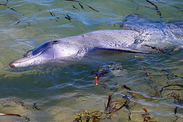
A dolphin at Monkey Mia in the marine park
|
|
| Nearest town or city | Denham |
| Established | 1989 |
| Area | 7,487.25 km2 (2,890.8 sq mi) |
| Managing authorities | WA Department of Parks and Wildlife |
| Website | Shark Bay Marine Park |
| See also | List of protected areas of Western Australia |
The Shark Bay Marine Park is a special protected area in Western Australia. It's part of the amazing Shark Bay region, which is so important that it's listed as a World Heritage Site by UNESCO. This huge marine park covers about 748,725 hectares (that's like 1.8 million acres!) and is located far north of Perth, about 800 kilometers away. It was created in 1989 to help protect its unique environment.
Contents
What is Shark Bay Marine Park?
The Shark Bay Marine Park is a huge underwater wonderland. It's famous for its incredible marine animals, like the friendly dolphins at Monkey Mia, sea turtles, gentle dugongs, and different kinds of sharks. The park also has vast underwater meadows of seagrass. There are twelve different types of seagrass found here. These seagrass beds are a very important part of the Shark Bay World Heritage Area.
Where is the Park Located?
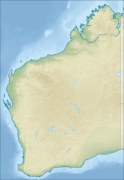
The marine park is located in the Gascoyne region of Western Australia. It is about 800 kilometers north of Perth. The closest town is Denham. The park's boundaries stretch from Steep Point in the south to Cape Inscription in the north of Dirk Hartog Island.
Amazing Animals of Shark Bay
Shark Bay Marine Park is home to many different marine animals. It's a safe place for them to live and grow.
- Dolphins: The dolphins at Monkey Mia are very famous. They often come close to the shore, which allows people to see them up close.
- Dugongs: These gentle giants are also known as "sea cows." Shark Bay has one of the largest populations of dugongs in the world. They love to eat the seagrass found in the park.
- Turtles: Several species of sea turtles live in the park's waters. They use the area for feeding and nesting.
- Sharks: As the name suggests, different types of sharks can be found in Shark Bay. They are an important part of the ocean's ecosystem.
Underwater Gardens: Seagrass Meadows
One of the most important features of Shark Bay Marine Park is its huge seagrass meadows. These underwater "gardens" are vital for many reasons:
- They provide food for animals like dugongs and turtles.
- They are a safe place for young fish and other marine creatures to hide and grow.
- They help keep the water clean and clear.
- There are twelve different species of seagrass in the park, making it a very special place for marine plants.
Fishing Rules in the Park
Fishing in the Shark Bay Marine Park is managed by special rules called the Gascoyne Fishing Rules. These rules help protect the marine life while allowing some fishing in certain areas. The park is divided into different zones:
- Eastern Gulf Zone: This area is east of the Peron Peninsula. Fishing is not allowed in the southern part of this zone. This no-fishing area is called the Hamelin Pool Marine Nature Reserve.
- Denham Sound: Also known as the Western Gulf Zone, this area has its own specific rules for fishing.
These rules help make sure that the marine park stays healthy for all the animals and plants that live there.
 | Aaron Henry |
 | T. R. M. Howard |
 | Jesse Jackson |


