
Karijini National Park facts for kids
Quick facts for kids Karijini National ParkWestern Australia |
|
|---|---|
|
IUCN Category II (National Park)
|
|

Dales Gorge
|
|

Karijini National Park
Location in Western Australia
|
|
| Nearest town or city | Tom Price |
| Established | 1969 |
| Area | 6,274.22 km2 (2,422.5 sq mi) |
| Visitation | 166,000 (in 2009) |
| Managing authorities | Department of Parks and Wildlife (Western Australia) |
| Website | Karijini National Park |
| See also | List of protected areas of Western Australia |
Karijini National Park is a huge national park in Western Australia. It's found in the Pilbara region, which is in the northwest part of the state. The park is located far north of Perth, the capital city. It used to be called Hamersley Range National Park until 1991.
Karijini is the second largest national park in Western Australia. It covers about 6,274 square kilometers. The rocks here are incredibly old, estimated to be 2.5 billion years old! The best time to visit is from May to September. During these months, the days are warm, but the nights can be quite cold. Summer temperatures can reach over 38°C (101°F), making it very hot and increasing the risk of bushfires.
The park is split into two parts by a railway line and a large iron ore mine. Most of the cool places to visit, like the amazing gorges and waterfalls, are in the northern part. You can get to these spots using paved and gravel roads. The southern part of the park does not have paved roads.
You can fly to Paraburdoo Airport or Newman Airport to get close to Karijini. Both airports offer rental cars to help you explore the park.
Contents
History of Karijini
Karijini National Park is the traditional home of the Banyjima, Kurrama, and Innawonga Aboriginal people. They have lived here for over 20,000 years! The Banyjima name for the Hamersley Range, where the park is located, is Karijini. This means "Hilly Place" in English.
Aboriginal people used special ways to manage the land, like "fire-stick farming". This helped create different types of plants and habitats. These practices shaped the kinds of plants and animals you see in the park today. In 1861, an explorer named F.T. Gregory explored this area. He named the Hamersley Range after his friend, Edward Hamersley.
Weather in the Park
Karijini National Park is in the Pilbara region, which has a mostly dry, tropical climate. This means it's usually hot and sunny. In summer, you might experience big thunderstorms and even cyclones. These bring about 250–350 millimeters (10–14 inches) of rain each year. Summer days are often hotter than 40 degrees Celsius (104°F). But watch out, winter nights can get very cold, sometimes even freezing!
Amazing Geology
The park has several incredible gorges that show off layers of ancient rock. These rock layers are like pages in a history book, telling us about Earth's past. Some of the notable rock types you can see include:
- Banded iron formation – These rocks have cool stripes of iron.
- Dolomite – A type of rock that often forms in water.
- Shale – A soft, layered rock.
Some of the famous gorges where you can see these layers are Dales, Kalamina, Wittenoom, and Yampire Gorges.
Animals of Karijini

Karijini National Park is home to many different animals. You might spot red kangaroos hopping around. There are also euros and rock-wallabies, which are smaller relatives of kangaroos. Look out for spiky echidnas digging for ants!
The park also has many reptiles like geckos, goannas, and various snakes, including pythons. If you're lucky, you might see some bats flying at dusk. A wide variety of birds also live in the park, making it a great place for birdwatching.
Park Features and Safety

Karijini National Park is famous for its many deep gorges. These gorges often have narrow slot canyons, beautiful waterfalls, and cool water holes. Visitors often enjoy swimming in these cold pools, especially on hot days.
Some of the main gorges include Hamersley Gorge in the northwest and Munjina Gorge in the east. In the center of the park, you'll find a cluster of amazing gorges like Hancock, Joffre, Knox, Red, and Weano Gorges.
While the park is open for everyone to enjoy, it's important to be careful in certain areas. Near the northern edge of the park, especially around Yampire and Wittenoom Gorges, there are natural minerals in the rocks. It's best to stay on marked paths and follow all safety signs to ensure a fun and safe visit.
Images for kids
-
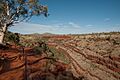
Dales Gorge
-
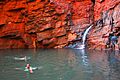
Handrail Pool in Weano Gorge
-
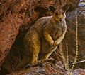
A Rock-wallaby
See also
 In Spanish: Parque nacional Karijini para niños
