
Montebello Islands facts for kids


The Montebello Islands, also called the Monte Bello Islands, are a group of about 174 small islands. About 92 of these islands have names. They are located about 20 kilometers (12 miles) north of Barrow Island. This is off the Pilbara coast of north-western Australia.
The islands are a special marine conservation area. This area covers 58,331 hectares (about 144,138 acres). The Western Australian Department of Environment and Conservation manages this reserve. The Montebello Islands were also where the British military tested three nuclear weapons in the air. These tests happened in 1952 and 1956.
Contents
About the Islands
The islands in this group have a total land area of about 22 square kilometers (8.5 square miles). The two biggest islands are Hermite and Trimouille. Hermite Island is about 1,022 hectares (2,525 acres). Trimouille Island is about 522 hectares (1,290 acres).
The islands are made of limestone rock and sand. The rocky areas have Triodia hummock grassland. There are also scattered shrubs. The sandy areas have grasses, sedges, and shrubs, mostly Acacia. Some mangroves grow in calm bays and channels. You can find them especially at Hermite Island. The weather here is hot and very dry. The islands get about 320 millimeters (12.6 inches) of rain each year.
Island Wildlife
Birds
BirdLife International has named the Montebello Islands an Important Bird Area (IBA). This is because more than 1% of the world's fairy and roseate terns live here. The islands are also important for sooty oystercatchers.
Greater crested terns sometimes breed here in large numbers. Other birds that breed on the islands include ospreys and white-bellied sea eagles. You can also find pied oystercatchers, Caspian terns, and bridled terns. The islands are home to 12 to 15 breeding pairs of beach stone-curlews. Yellow white-eyes have also been seen here.
Mammals
Invasive feral cats and black rats have been removed from the islands. This has helped endangered animals. Rufous hare-wallabies (mala) and Shark Bay mice have been brought to the islands. This helps protect these threatened species. They are now common on many of the larger islands.
-
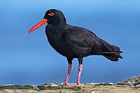
The islands are an important site for sooty oystercatchers
-
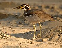
Beach stone-curlews live on the islands
-
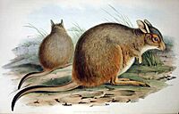
Mala have been brought to the islands


Island History
Old remains show that indigenous Australians visited the islands. This was until about 8,248 years ago. At that time, the world got warmer and sea levels rose. This caused the Montebello Islands to become separated from the mainland. People then had to leave the islands.
In 1622, an English ship called Tryall crashed. It hit hidden rocks about 32 kilometers (20 miles) northwest of the islands. Thirty-five people from the ship sailed a small boat to the Montebello Islands. They stayed there for seven days. This was the first recorded shipwreck in Australian waters. It was also the first time Europeans stayed for a longer period in Australia.
In 1801, [[Nicolas Baudin led a French exploration trip. He named the island group after the Battle of Montebello from 1800. He named Hermite Island after Admiral Jean-Marthe-Adrien L'Hermite. Trimouille Island was named after French general Louis II de la Trémoille.
The islands were important for pearl fishing. This happened from the late 1800s until the start of the Second World War.
British Nuclear Tests

The Montebello Islands were used for three nuclear weapon tests by the British military. These tests were done in the air. One test happened in 1952, and two more happened in 1956.
HMS Plym was a ship anchored near Trimouille Island. It was the site of Operation Hurricane. This was the first atomic weapon test ever done by the United Kingdom. It happened on October 3, 1952.
Later British tests were done on mainland Australia. But in 1956, two more tests were done on Trimouille and Alpha Islands. These bombs were placed on tall towers. The second of these tests was called "Mosaic G2." It was the biggest nuclear explosion in Australia. It had a power of 60 kilotons. The "Mosaic G2" test caused a lot of radioactive material to spread. This material affected large areas of mainland Australia. It reached towns in Queensland like Mount Isa, Julia Creek, Longreach, and Rockhampton.
Named Islands
Here are some of the larger named islands:
- North-West Island
- Primrose Island
- Bluebell Island
- Alpha Island
- Crocus Island
- Campbell Island
- Delta Island
- Renewal Island
- Ah Chong Island
There are also 10 named groups of smaller islets. The individual islands in these groups do not yet have names:
- Corkwood Islands
- Fig Islands
- Hakea Islands
- Jarrah Islands
- Jasmine Islands
- Karri Islands
- Marri Islands
- Minnieritchie Islands
- Mulga Islands
- Quandong Islands
See also
 In Spanish: Islas Montebello para niños
