
Cape Barren Island facts for kids
|
Native name:
truwana
|
|
|---|---|

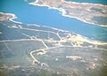
Cape Barren Island (center) from space, January 1997
|
|

Cape Barren Island (Tasmania)
|
|
| Geography | |
| Location | Bass Strait |
| Coordinates | 40°24′07″S 147°59′28″E / 40.402°S 147.991°E |
| Area | 478.4 km2 (184.7 sq mi) |
| Highest elevation | 715 m (2,346 ft) |
| Highest point | Mount Munro |
| Administration | |
|
Australia
|
|
| State | Tasmania |
| LGA | Municipality of Flinders Island |
| Largest settlement | The Corner (pop. 60) |
| Demographics | |
| Population | 66 (2016) |
| Pop. density | 0.14 /km2 (0.36 /sq mi) |
| Official name: Cape Barren Island,east coast lagoons | |
| Designated: | 16 November 1982 |
| Reference #: | 256 |
Cape Barren Island, also called truwana, is a cool island in Bass Strait, off the north-east coast of Tasmania, Australia. It's about 478 square kilometers big. This makes it the second-largest island in the Furneaux Group. Flinders Island is bigger and to the north, while Clarke Island is smaller and to the south.
The tallest spot on the island is Mount Munro, which is 715 meters high. It's named after James Munro, a sealer who lived nearby a long time ago. The island's south-eastern tip was named 'Cape Barren' by explorer Tobias Furneaux in 1773.
Today, about 66 people live on the island (as of 2016). Most of them live in a small town called The Corner on the north-west coast. Did you know Australia's only native goose, the Cape Barren goose, was first seen by European explorers right here?
Contents
Island History: What Happened Here?
Early Sealing Days
People started hunting seals on Cape Barren Island in 1798. A ship called Nautilus came from Sydney to collect seal skins. In their first season, they gathered almost 9,000 skins! More ships came from Sydney and the United States. Sometimes, sealers from different countries even fought over the best hunting spots.
The Aboriginal Community
Today, about 70 Aboriginal people live on Cape Barren Island. Most of them are descendants of Aboriginal and European people. These families first lived on smaller islands nearby. They moved to Cape Barren Island in the late 1870s.
In 1881, the government of Tasmania set up a special area for them. They also started providing basic services to the community. By 1908, the island's population had grown to 250 people.

Changes and Challenges
More government involvement began in 1912 with a law called the Cape Barren Act. This law aimed to help the community become self-sufficient. However, government visitors in the 1920s and 1930s reported problems with health and education. There were even ideas to remove children from their families.
Because of this, many families moved to mainland Tasmania. By 1944, the population had dropped to 106 people. From the 1950s, some children were indeed removed from their parents. This was part of a wider government policy in Australia. It led to what is known as the "stolen generations".
New Beginnings
From the 1970s, government policies started to change. They began to recognize the rights of individuals more and more.
On May 10, 2005, the government officially gave Crown lands on Cape Barren and Clarke Island to the local Aboriginal association. This was a very important moment. It was the first time Crown land was given to an Aboriginal community in Tasmania.
East Coast Lagoons: A Special Wetland
On November 16, 1982, the lagoons on the east coast of Cape Barren Island became a special place. They were named a Ramsar site. This means they are recognized as important wetlands around the world.
This area is about 4,370 hectares of shallow, salty lagoons. It also has coastal sand dunes and beaches. Many unique plants grow here, including some rare ones. It's also a home for many different waterbirds.
Getting to Cape Barren Island
By Air
Airlines of Tasmania offers flights to the island twice a week from Launceston. You can also find other companies that offer special charter flights. These flights can come from either Tasmania, Australia or Victoria, Australia.
By Boat
If you're on Flinders Island, Cape Barren Island is just a short boat ride away. The islands in the Furneaux Group, including Cape Barren, are popular for sea kayakers. Many kayakers try to cross Bass Strait from Wilsons Promontory, Victoria, to the Tasmanian mainland.
Images for kids
-
The settlement on Cape Barren Island
