Furneaux Group facts for kids
 |
|
| Etymology | Tobias Furneaux |
|---|---|
| Geography | |
| Location | Bass Strait |
| Coordinates | 40°06′54″S 148°06′54″E / 40.11500°S 148.11500°E |
| Total islands | approx. 100 |
| Major islands | Flinders Island, Cape Barren Island, and Clarke Island |
| Area | 2,010.3 km2 (776.2 sq mi) |
| Administration | |
| State | Tasmania |
| Local government | Flinders Council |
| Demographics | |
| Population | 795 |
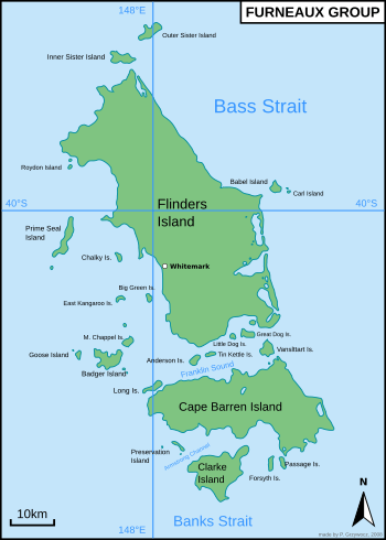
The Furneaux Group is a collection of about 100 islands located in Bass Strait, a sea channel between Victoria and Tasmania, Australia. These islands are found at the eastern end of the strait. They were named after a British explorer, Tobias Furneaux. He saw the eastern side of these islands in 1773 while sailing to New Zealand.
Later, in 1798, another explorer named Matthew Flinders was the first European to fully explore the Furneaux Islands. He did this in his ships, the Francis and the Norfolk.
The biggest islands in this group are Flinders Island, Cape Barren Island, and Clarke Island. There are five main towns or settlements on the islands: Killiecrankie, Emita, Lady Barron, Cape Barren Island, and Whitemark. Whitemark is on Flinders Island and is the main town for the Flinders Council, which manages the islands. Some people also live and farm on the smaller, more remote islands.
Contents
A Look at the Past: History of the Islands
In 1798, people discovered that many seals lived around the Furneaux Group. Because of this, the islands became a very busy place for hunting seals in Bass Strait. People hunted seals for their fur and oil. Records show that 29 islands in the Furneaux Group have links to this sealing history from the 1800s.
An important Aboriginal woman named Dolly Dalrymple was born on the Furneaux Islands. Her mother, an Aboriginal woman, came to the islands with a sealer named George Briggs.
It's important to know that King Island, which is at the western end of Bass Strait, is not part of the Furneaux Group.
How the Islands Were Formed: Geology
The rocks that make up these islands are very old. They include granite from the Devonian period, which was millions of years ago. There are also newer layers of loose limestone and sand from the Cenozoic periods.
During the last ice age, a long time ago, the sea level was much lower. At that time, a natural land bridge connected Tasmania to the Australian mainland right through where these islands are now.
Islands in the Group
The Furneaux Group is made up of many islands, big and small. Here are some of the main ones and their groups:
- Flinders Island: This is the largest island in the group. Its main town is Whitemark.
- Cape Barren Island: This is the second largest island.
- Clarke Island: This is another one of the larger islands.
- Babel Island Group: This group includes Babel Island, Cat Island, and Storehouse Island.
- Badger Island Group: This group includes Badger Island, Goose Island, and Mount Chappell Island.
- Big Green Island Group: This group has islands like Big Green Island and East Kangaroo Island.
- Franklin Sound Islands Important Bird Area: This area is important for birds and includes islands like Great Dog Island, Long Island, and Tin Kettle Island.
- Other notable islands: Some other islands in the group are Inner Sister Island, Outer Sister Island, Passage Island, and Preservation Island.
See also
 In Spanish: Grupo Furneaux para niños
 | John T. Biggers |
 | Thomas Blackshear |
 | Mark Bradford |
 | Beverly Buchanan |


