Flinders Island facts for kids
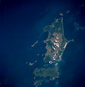
The Furneaux Group as viewed from space, April 1993
|
|
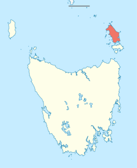
Flinders Island, as shaded, located in the Bass Strait
|
|
| Etymology | Matthew Flinders |
|---|---|
| Geography | |
| Location | Bass Strait |
| Coordinates | 40°00′S 148°03′E / 40.000°S 148.050°E |
| Archipelago | Furneaux Group |
| Area | 1,367 km2 (528 sq mi) |
| Area rank | 2nd in Tasmania |
| Length | 62 km (38.5 mi) |
| Width | 37 km (23 mi) |
| Highest elevation | 756 m (2,480 ft) |
| Highest point | Mount Strzelecki |
| Administration | |
|
Australia
|
|
| State | Tasmania |
| LGA | Municipality of Flinders Island |
| Largest settlement | Whitemark (pop. 170) |
| Demographics | |
| Population | 922 (2021) |
| Pop. density | 0.673 /km2 (1.743 /sq mi) |
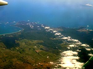
Flinders Island is the biggest island in the Furneaux Group. It covers about 1,367 square kilometers. This island is located in the Bass Strait, which is northeast of Tasmania. Today, Flinders Island is part of the state of Tasmania, Australia. It is about 54 kilometers from Cape Portland. The island sits at 40° south latitude, a windy area known as the Roaring Forties.
Contents
Island History
Early Inhabitants
People first lived on Flinders Island at least 35,000 years ago. They traveled from Australia across a land-bridge that is now the Bass Strait. A group of people lived there until about 4,500 years ago. They faced tough times due to a big climate change, leading to a lack of water and food.
European Explorers Arrive
Some islands in the Furneaux Group were first noted in 1773. This was done by British navigator Tobias Furneaux. He was the commander of HMS Adventure, a ship with James Cook on his second voyage.
In February 1798, another British navigator, Matthew Flinders, mapped some southern islands. He used a small boat from the schooner Francis. Later that year, Flinders returned and finished mapping the islands in the Norfolk. He then sailed all the way around Tasmania (1798–99). He was joined by George Bass. They proved Tasmania was an island, separated from mainland Australia by Bass Strait. The strait was later named after George Bass.
How Flinders Island Got Its Name
James Cook named the islands "Furneaux's Islands" after Tobias Furneaux. Matthew Flinders named the biggest island "Great Island." He also named a group of mountains on Flinders Island the "Three Patriarchs." A small island nearby, Flinders named "Babel Island" because of the loud noises made by seabirds there. Later, Phillip Parker King named the largest island "Flinders Island," after Matthew Flinders.
Settlement on the Island
In the late 1700s, sealers often visited the island. They sometimes brought Aboriginal women, who had been taken from their tribes. The number of seals quickly dropped. The last permit for sealing was given in 1828. Many sealers' families decided to stay in the Furneaux Group. They made a living by raising cattle and hunting muttonbirds.
Wybalenna Aboriginal Establishment
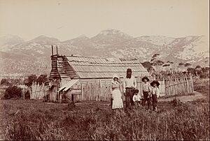
Starting in 1831, the remaining Tasmanian Aboriginal people were moved. First, they went to "The Lagoons" near what is now Whitemark. Then, in 1833, they were moved to the Wybalenna Aboriginal Establishment at Settlement Point. "Wybalenna" means "dwellings" or "Black Man's Houses." About 180 Aboriginal people were moved there. The idea was to keep them safe from white settlers. However, living conditions were very poor. Around 130 Aboriginal people died at Wybalenna. This forced relocation plan did not last long.
In 1847, the Aboriginal people asked Queen Victoria for help. After their campaign, the remaining 47 Aboriginal people were moved again. This time, they went to Oyster Cove Station. This was a former convict settlement south of Hobart, Tasmania's capital. Land on nearby Cape Barren Island was officially set aside for the Aboriginal community in 1881.
Soldier Settlement Programs
From the late 1800s, land was given out for private ownership. But it was not until the 1950s that a proper settlement plan began. This plan mostly brought settlers from mainland Tasmania and central New South Wales to Flinders Island's eastern shore. The Municipality of Flinders Island was created in 1903.
Geography and Nature
Flinders Island is part of Tasmania. It is also part of the Municipality of Flinders Island local government area. Flinders Island is the largest island in this area. It is the only island with more than one permanent town.
The island is about 62 kilometers long from north to south. It is about 37 kilometers wide from east to west. Its total land area is about 1,333 square kilometers. Mount Strzelecki in the southwest is the island's highest point, at 782 meters. About one-third of the island is mountainous and rough. It has granite ridges running along its length. The coastal areas have a lot of sand, often forming dunes. Many coastal lagoons are found along the eastern shore. These lagoons are formed by dunes blocking water drainage. Small streams provide most of the water flow. Few of these streams flow directly into Bass Strait or a lagoon all year round.
The coastal areas are mostly covered in scrub or shrubs. Higher up, the plants are mainly eucalyptus trees. The Furneaux Group has over 800 different plant species. This shows the amazing variety of life in its ecosystem.
Animal Life
Native birds include the Cape Barren goose and the short-tailed shearwater. Mammals like Bennett's wallaby, brushtail possum, and Tasmanian pademelon live here. The cape fur seal is the only common placental mammal. Flinders Island is also the last home for a special type of common wombat. This wombat is listed as vulnerable, meaning it is at risk. The area around Mount Strzelecki is Strzelecki National Park. Wild turkeys also live on the island.
Island Climate
Flinders Island has a mild oceanic climate. The Bass Strait makes the weather very steady. Summers are drier and less cloudy than winters. The island gets less than 800 millimeters of rain each year.
| Climate data for Flinders Island Airport (1991–2020 normals, extremes 1942–present) | |||||||||||||
|---|---|---|---|---|---|---|---|---|---|---|---|---|---|
| Month | Jan | Feb | Mar | Apr | May | Jun | Jul | Aug | Sep | Oct | Nov | Dec | Year |
| Record high °C (°F) | 41.5 (106.7) |
39.4 (102.9) |
35.6 (96.1) |
31.7 (89.1) |
27.4 (81.3) |
20.3 (68.5) |
21.4 (70.5) |
22.7 (72.9) |
29.5 (85.1) |
32.7 (90.9) |
35.9 (96.6) |
40.5 (104.9) |
41.5 (106.7) |
| Mean daily maximum °C (°F) | 22.6 (72.7) |
22.7 (72.9) |
21.4 (70.5) |
18.7 (65.7) |
16.3 (61.3) |
14.3 (57.7) |
13.6 (56.5) |
13.9 (57.0) |
15.3 (59.5) |
17.0 (62.6) |
18.9 (66.0) |
20.7 (69.3) |
18.0 (64.4) |
| Mean daily minimum °C (°F) | 13.9 (57.0) |
14.1 (57.4) |
12.6 (54.7) |
10.6 (51.1) |
9.0 (48.2) |
7.1 (44.8) |
6.7 (44.1) |
6.8 (44.2) |
7.8 (46.0) |
8.7 (47.7) |
10.5 (50.9) |
12.3 (54.1) |
10.0 (50.0) |
| Record low °C (°F) | 2.6 (36.7) |
4.0 (39.2) |
1.6 (34.9) |
−0.4 (31.3) |
−1.7 (28.9) |
−2.5 (27.5) |
−3.5 (25.7) |
−3.0 (26.6) |
−2.5 (27.5) |
−1.4 (29.5) |
0.5 (32.9) |
2.5 (36.5) |
−3.5 (25.7) |
| Average precipitation mm (inches) | 52.9 (2.08) |
32.3 (1.27) |
40.4 (1.59) |
50.6 (1.99) |
62.8 (2.47) |
68.3 (2.69) |
66.0 (2.60) |
72.5 (2.85) |
58.9 (2.32) |
47.2 (1.86) |
55.9 (2.20) |
57.0 (2.24) |
668.3 (26.31) |
| Average precipitation days (≥ 0.2 mm) | 8.1 | 7.3 | 8.5 | 11.6 | 14.6 | 15.9 | 17.0 | 17.3 | 14.5 | 12.3 | 10.0 | 10.2 | 147.3 |
| Mean monthly sunshine hours | 238.7 | 220.4 | 220.1 | 183.0 | 148.8 | 117.0 | 142.6 | 192.2 | 192.0 | 223.2 | 228.0 | 244.9 | 2,350.9 |
| Source: Bureau of Meteorology | |||||||||||||
Flinders Island usually has about 5 days a year over 30°C (86°F). It has about 6 days a year below 0°C (32°F). The average wind speed is 21–25 km/h (13–15 mi/h).
Important Bird Areas
Parts of Flinders Island are very important for birds. These areas are called Important Bird Areas (IBAs).
Central Flinders Island IBA
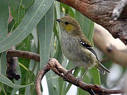
A 30 square kilometer area, mostly north and east of Whitemark, is an IBA. It has three breeding groups of the endangered forty-spotted pardalote. It also provides homes for flame robins. Many of Tasmania's unique bird species live here too. These include the green rosella and the yellow-throated honeyeater.
Eastern Flinders Island IBA
Another IBA is a 187 square kilometer strip along the eastern coast. It is 70 kilometers long. This area supports small numbers of fairy terns. It also has many hooded plovers. Over 1% of the world's chestnut teal and oystercatcher populations live here.
Population and Towns
In 2011, about 700 people lived on Flinders Island. The average age was 45.
The main towns are Whitemark and Lady Barron. Whitemark has the island's main airport and about 155 people (in 2011). Lady Barron has about 110 people. Other smaller places include Blue Rocks, Killiecrankie, Wingaroo, and Wybalenna.
The population is growing. In 2016, the whole local government area (Flinders and Cape Barren Islands) had 906 people. This was up from 776 in 2011. By 2019, it reached 1010 people. The population of Flinders Island itself (postal code 7255) was 833 in 2016. This was a rise of over 18% from 2011. The average age of people in the Municipality has gone up slightly. The number of families has also increased.
Getting Around and Connecting
Since October 4, 2010, Sharp Airlines has flights. They fly between Essendon, Flinders Island, and Launceston. They use 19-seat planes. There are three return flights a week between Essendon Airport and Flinders Island Airport (65 minutes). Flights between Launceston Airport and Flinders Island Airport happen daily (25 minutes). Other companies also offer charter flights.
A ferry service brings food and fresh goods to the island every week. Furneaux Freight operates this service. It sails between Bridport, Tasmania and Lady Barron, Tasmania. There is also a monthly ferry from Port Welshpool, Victoria.
Telstra, an Australian company, provides the only mobile phone service on the island. They offer 3G and 4G coverage. Internet access is available through satellite or by using the 3G/4G mobile network.
See also
 In Spanish: Isla Flinders para niños


