
Port Phillip facts for kids
Quick facts for kids Port Phillip |
|
|---|---|
| Port Phillip Bay | |

The Melbourne skyline, seen across Port Phillip.
|
|

Port Phillip
Location in Victoria
|
|

Map of the Port Phillip area
|
|
| Coordinates | 38°09′S 144°52′E / 38.150°S 144.867°E |
| Type | Saline, Permanent, Natural |
| Primary inflows | Yarra River, Patterson River, Werribee River, Little River, Kororoit Creek |
| Primary outflows | Bass Strait |
| Basin countries | Australia |
| Surface area | 1,930 km2 (750 sq mi) |
| Average depth | 8 m (26 ft) |
| Max. depth | 24 m (79 ft) |
| Water volume | 25 km3 (6.0 cu mi) |
| Shore length1 | 264 km (164 mi) |
| Surface elevation | 0 m (0 ft) |
| Islands | Swan Island, Duck Island, Mud Islands |
| Settlements | Melbourne, Geelong, Frankston, Mornington, Queenscliff, Sorrento |
| 1 Shore length is not a well-defined measure. | |
Port Phillip (Kulin: Narm-Narm), also known as Port Phillip Bay, is a large, horsehead-shaped bay on the central coast of southern Victoria, Australia. It connects to the Bass Strait through a short, narrow channel called The Rip. The bay is surrounded by towns and cities, including Greater Melbourne to the north and east, and city of Greater Geelong to the west.
Port Phillip covers about 1,930 square kilometers (745 sq mi) and has a shoreline stretching roughly 264 kilometers (164 mi). It holds about 25 cubic kilometers (6 cubic miles) of water. Most of the bay is good for boats, but it's quite shallow for its size. The deepest part is only 24 meters (79 ft), and half of the bay is shallower than 8 meters (26 ft). Its waters and coast are home to many animals like seals, whales, dolphins, corals, and various seabirds and migratory waders.
Before Europeans arrived, the land around Port Phillip belonged to the Wathaurong (west), Wurundjeri (north), and Boonwurrung (south and east) people. They were all part of the Indigenous Kulin nation. The first Europeans to enter the bay were the crews of HMS Lady Nelson, led by John Murray, and then HMS Investigator, led by Matthew Flinders, both in 1802.
In 1803, an expedition tried to set up the first European settlement in Victoria near Sorrento, but it was abandoned in 1804. Thirty years later, settlers from Tasmania came back. They founded Melbourne (now Victoria's capital) at the mouth of the Yarra River in 1835, and Geelong at Corio Bay in 1838. Today, Port Phillip is surrounded by many people, with an estimated 5.5 million living around the bay. Melbourne's suburbs stretch along most of the northern and eastern shores, and Geelong spreads around Corio Bay.
Contents
History of Port Phillip Bay
How the Bay Formed

Port Phillip formed between 8000 BCE and 6000 BCE, after the last Ice Age. As the sea-level rose, it flooded the huge river plains, wetlands, and lakes that were once the lower parts of the Yarra River. The ancient Yarra River used to flow through what is now the middle of the bay. It formed a coastal lake in the southern part of the bay, blocked by The Heads, and then flowed into a closed bay over the western part of the prehistoric Bassian Plain, which later became the Bass Strait.
First People of the Bay
Aboriginal people lived in this area long before the bay formed, with proof of their presence dating back at least 40,000 years. Stories passed down by the Boonwurrung Elder Ningerranarro tell of his ancestors hunting kangaroos and possums where the bay now lies.
Large piles of old seashells, called middens, can still be seen around the shoreline. These mark places where Aboriginal people held feasts. They lived well from the rich sea-life, including penguins and seals. In colder weather, they wore possum-skin cloaks and beautiful feathered head-dresses.
Earthquakes Around the Bay
Small earthquakes have been felt around Port Phillip since the 1800s. Old newspaper reports mention these events. For example, an earthquake in July 1885 was reported to have affected areas near Bass Strait and Port Phillip Bay.
Anthony's Nose is a rocky cliff made of Devonian granite on the Mornington Peninsula. It's where Arthurs Seat mountain slopes steeply down towards Port Phillip.
European Discovery

In 1800, Lieutenant James Grant was the first known European to sail through Bass Strait from west to east in HMS Lady Nelson. He saw the south coast but didn't enter Port Phillip.
The first Europeans to find and enter Port Phillip were the crew of the Lady Nelson, led by John Murray. They sailed into the bay on February 15, 1802. The local Kulin people called the bay Narm-Narm. Murray named it Port King, after the Governor of New South Wales, Philip Gidley King. Later, on September 4, 1805, Governor King officially renamed it Port Phillip, honoring his predecessor Arthur Phillip. Murray anchored the Lady Nelson near what is now Sorrento Beach.
During this trip, Murray wrote in his journal about meeting local Aboriginal people. This meeting started in a friendly way with trading and sharing. However, it was suddenly interrupted by a violent attack from a large group of Aboriginal people. Murray's crew fired back, injuring some of the Aboriginal people. After exploring the southern part of the bay, Murray officially claimed the area for King George III of Great Britain on March 8, 1802, at a place now called Point King Foreshore Reserve in Sorrento.
About ten weeks after Murray, Matthew Flinders also found and entered the bay in HMS Investigator, not knowing Murray had been there. Because of reports from Murray and Flinders, Governor King sent Lieutenant Charles Robbins in HMS Cumberland to fully explore Port Phillip. This team, which included Charles Grimes, made a detailed map of Port Phillip, including the mouth of the Yarra River, which they visited on February 2, 1803. Robbins found Aboriginal homes and groups of people at Tootgarook, Carrum Carrum, along the Yarra River, and at Geelong.
Early British Settlements

Governor King decided to set up a convict settlement at Port Phillip. This was mainly to claim southern Australia before the French could. On October 10, 1803, two ships, HMS Calcutta and Ocean, led by Captain David Collins, arrived with 402 people. This group included officials, marines, and convicts.
After looking around, they decided to build the settlement at Sullivan Bay, very close to where Sorrento is today. They landed on October 17, 1803. On October 25, the British flag was raised over the small settlement.
The first European child in Victoria was born here on November 25 and was named William James Hobart Thorne. The first marriage happened on November 28. However, because there wasn't enough fresh water or good timber, this first British attempt to settle the area was given up on January 27, 1804. Before leaving, some convicts, including William Buckley, escaped. Buckley lived in a cave near Point Lonsdale and later lived with an Aboriginal Australian group for many years.
Port Phillip was then mostly left alone until 1835. That's when settlers from Tasmania, led by John Batman and John Pascoe Fawkner, established Melbourne on the lower Yarra River. John Batman met William Buckley, who became an important translator with the local Aboriginal tribes. In 1838, Geelong was founded and became a major port for the growing wool industry. For a while, Geelong was a strong competitor to Melbourne. But the Gold Rush that started in 1851 made Melbourne the biggest town in Victoria.
Melbourne's Growth and Development
As Melbourne grew, wealthy people started using Port Phillip for fun. Beachside suburbs like St Kilda and Brighton were built on the bay's east shore. Later, resorts further south like Sorrento and Portsea became popular. The swampy western shores were less popular and were mainly used for farming, the Point Cook Royal Australian Air Force base, and nature reserves. In recent years, more people have moved to the western side of the bay.
Today, properties along the Port Phillip coastline are still very popular. People use Port Phillip for many fun activities like swimming, cycling, boating, and fishing. The bay also has historical walks and places to see wildlife. The traditional Aboriginal owners of the land are recognized at many sites around the bay.
Geography of Port Phillip
Port Phillip is in southern Victoria, separated from Bass Strait by the Bellarine Peninsula to the southwest and the Mornington Peninsula to the southeast. It's the largest bay in Victoria. The narrow entrance to the bay, called the Rip, is between Point Lonsdale and Point Nepean. It has strong tidal currents because of the uneven seabed. Large ships need special local guides to enter and exit. Work has been done to deepen the channel entrance so bigger container ships can reach Melbourne's docks.
The eastern side of the bay has sandy beaches from St Kilda down to Portsea. Sand moves along the shore with the seasons. On the western side, there are different types of beaches, including sandy and sandstone rock beaches, found at Queenscliff and Geelong's Eastern Beach. Many sandbanks and shallow areas are in the southern part of the bay.
Climate Around the Bay
The region has an oceanic climate with warm summers and mild winters. It can get very hot on some summer days due to northerly winds. Rainfall is spread evenly throughout the year, but it varies a lot. The northwestern shore is the driest part of southern Victoria, while the eastern shores get more rain. Summer temperatures are usually around 25°C (77°F) during the day and 14°C (57°F) at night. In winter, a typical day ranges from 6°C (43°F) to 14°C (57°F).
Port Phillip is often warmer than the surrounding ocean or land, especially in spring and autumn. This can cause a "bay effect," where showers become stronger on the side of the bay where the wind is blowing (especially in Melbourne's eastern suburbs).
Beaches of Port Phillip
_seen_from_Frankston.jpg)
Port Phillip has many beaches that are flat, shallow, and long, with very small waves. This makes them safe for swimming and attracts many families during summer and school holidays. Water sports like body boarding and surfing are hard to do here, except in very stormy weather. However, stand-up paddleboarding (SUP), kitesurfing, and windsurfing are very popular. Most sandy beaches are on the bay's northern, eastern, and southern shorelines. The western shore has fewer sandy beaches and more swampy wetlands and mangroves. You can also find some pebble beaches and rocky cliffs, mostly in the southern parts.
- Major beaches include: St. Kilda Beach, Brighton Beach, Sandringham Beach, Dromana Beach.
Rivers and Creeks Flowing into the Bay
- Rivers: Yarra River, Maribyrnong River, Patterson River, Little River, Werribee River.
- Creeks: Elwood Canal, Mordialloc Creek, Kananook Creek, Sweetwater Creek, Balcombe Creek, Chinamans Creek, Cowies Creek, Hovells Creek, Kororoit Creek.
Islands of Port Phillip
Because the bay is shallow, some artificial islands and forts have been built. However, it only has a few natural islands. Many sandy and muddy banks are found in the southern parts, like Mud Islands. Most islands are in the marshy shallow waters of Swan Bay. Some of the bay's main islands include:
- Swan Island
- Mud Islands
- Duck Island
- South Channel Fort (man-made)
- Pope's Eye (man-made)
Mountains and Hills Around the Bay


- Arthurs Seat 314 m
- Mount Martha 160 m
- Mount Eliza
- Olivers Hill
- Flinders Peak 364 m
Lakes Near Port Phillip
- Albert Park Lake
- Cherry Lake
- Lake Borrie
- Lake Carramar, Lake Illawong and Lake Legana of Patterson Lakes
- Lake Connewarre
- Lake Victoria
- RAAF Lake
- Sanctuary Lakes (man-made)
- Salt Lagoon
Ecology of Port Phillip


Jellyfish are a common sight in Port Phillip. The bay's waters are home to Australian fur seals, bottlenose dolphins, common dolphins, humpback whales, and southern right whales. Many other cetacean species might also visit. The smooth toadfish is one of the most common fish in muddy areas. The bay has unique species like the bluedevil fish and amazing sponge walls at the Lonsdale wall near the bay's entrance. It also has breeding colonies of Australian fur seals. Sometimes, other seals like Australian sea lions and leopard seals may enter the bay.
Swan Bay, next to Queenscliff, is an important feeding area for waterbirds and migratory waders. The Mud Islands, near Sorrento, are important breeding spots for white-faced storm petrels, silver gulls, Australian pelicans, and Pacific gulls. Salt marshes in the northwestern parts of the bay, like those in the Werribee Sewage Farm, are protected wetlands. The critically endangered orange-bellied parrot can be found in three wintering spots with saltmarsh habitat around Port Phillip. Various seabirds, like Australasian gannets, build nests on man-made structures in the bay.
Port Phillip has three Marine Sanctuaries managed by Parks Victoria. These areas protect the bay's amazing variety of life, its natural processes, and its historical features. The Environment Protection Authority of Victoria monitors the bay's water quality, which was rated as Good to Very Good in 2021-2022.
Original Animals and Plants
In the 1840s, a boy named George Gordon McCrae lived near Arthur's Seat. He later wrote about the amazing wildlife he saw. Here are some of the animals and plants he remembered:
- Animals: Huge groups of kangaroos, wallabies, paddy-melons, bandicoots, different kinds of possums, flying squirrels, flying mice, and dingoes. He also saw echidnas, large iguanas, tree lizards (up to 5 feet long), pythons, and rock lizards.
- Trees: Coast banksia, honey suckle, and grass trees.
- Sea Life: Scallops, cockles, snapper, mutton fish, coatfish, parrot fish, leather jackets, flathead, dog fish, sting rays, shark-tailed rays, and pig fish.
- Birds on Beaches: Pelicans, penguins, different types of gulls, pied oyster catchers, terns, cormorants, little sandpipers, and musk ducks.
- Birds in Swamps: The Nankeen bird, rails, bitterns, snipes, several types of ducks, spoonbills, black swans, geese, cranes, blue and white coots, water hens, kingfishers, and swamp parrots.
- Birds in Scrub: Honey eaters, warblers, red coat robins, emu wrens, Laughing jackasses, butcher birds, quail, and turkeys.
- Birds on Flats: Spur wing plovers, minas, and leatherheads.
- Birds in Timbers: Many kinds of parrots, lorries, rosellas, blue mountain parrots, Sulphur-crested white cockatoos, black cockatoos, grey cockatoos with scarlet crests, and corellas.
- Birds of Prey: Eagle hawks, falcons, and owls.
Dolphins and Whales
.jpg)
Small groups of common dolphins have made the eastern parts of the bay their home since the late 2000s. In recent years, more southern humpback and southern right whales have been entering Port Phillip. Southern right whales are still very rare in eastern Victorian waters, but seeing mother-calf pairs in the bay suggests that Port Phillip might have once been a place where these whales came to rest and have their babies. They often swim very close to shore in shallow, safe waters, sometimes right next to piers in Frankston.
Burrunan Dolphins
The bay is home to about 100 to 150 of a special type of bottlenose dolphin called the Burrunan dolphin (Tursiops australis). The only other place this rare species is found is in the Gippsland Lakes.
Shellfish Reefs Restoration
Port Phillip has lost over 95% of its native flat oyster and blue mussel reefs since Europeans settled here. In 2014, a project began to bring back these shellfish reefs in two places: off Hobsons Bay near St Kilda, and off Corio Bay near Avalon. They placed 300,000 native Angasi oysters on limestone rocks over a 600 square meter area. The goal of this project is to improve the variety of marine life, water quality, and fish habitats.
Environmental Concerns
Like the Yarra River that flows into it, Port Phillip faces problems with pollution and water quality. Litter, dirt, and harmful chemicals can affect the beaches so much that the EPA Victoria sometimes has to close them.
In 2008, a ship owner and captain were fined $35,000 for illegally dumping garbage into Port Phillip. To help protect the bay, an Environmental Management Plan was created for 2017-2027. This plan aims to improve water quality and ensure marine life can thrive. It also divides the responsibility for supervising the bay among the government, community, and industries.
Shipping in Port Phillip
History of Shipping


The southern part of the bay near the entrance has large sandbanks. A shipping channel was dug in an east-west direction from the entrance to near Arthur's Seat in the late 1800s, and it has been kept clear ever since. Early ships used piers at Sandridge (now Port Melbourne). Later, shipping moved to various wharves along the Yarra River, which are now part of the Port of Melbourne.
Today, the Port of Melbourne is Australia's busiest commercial port. It serves Australia's second-largest city and handles a huge amount of goods coming into and leaving the country. The Port of Geelong also handles a lot of bulk goods and oil.
In 2004, the Victorian Government started the Port Phillip Channel Deepening Project. This project aimed to make the existing shipping channels deeper so that newer, larger ships could use them. The project was completed in November 2009.
Shipping Channels
- South Channel – This channel goes east from the Rip to off the coast of Arthur's Seat. Large ships (up to 14.0m deep) can use this channel at any tide. It's the main commercial shipping channel in the south of the bay.
- West Channel – This channel goes northwest from the Rip and ends off the coast of St Leonards. It's not used for commercial shipping anymore, but smaller boats still use it.
- The Rip – Also called "the heads" for shipping. Ships up to 14.0m deep can go through at any tide. However, strong currents (up to 8 knots) can sometimes limit when ships can pass.
- Melbourne Channels – These channels go north through Hobsons Bay towards Station Pier and the entrance to the Yarra River. They are dredged to 15.5 meters deep and are the main shipping channels to Melbourne's ports. They include:
- Melbourne Channel
- Williamstown Channel
- Port Melbourne Channel
- Geelong Channels – These channels start off Point Richards and go west into Corio Bay. They split into two, heading north to the modern Port of Geelong and south to Cunningham Pier. The main Geelong channels are dredged to 12.3m. The City Channel is no longer used for commercial shipping. They include:
- Point Richards Shipping Channel
- Wilson Spit Shipping Channel
- Hopetoun Shipping Channel
- City Channel
- Corio Channel
Shipping and Cargo Docks
- Bulk Grain Pier
- Corio Quay
- Cunningham Pier
- Gellibrand Pier
- Lascelles Wharf
- Point Henry Pier
- Point Wilson Pier
- Princes Pier
- Refinery Pier
- Station Pier
- Webb Dock
Ferries in Port Phillip
- Searoad Ferries runs a car ferry service across the mouth of the bay between Queenscliff and Sorrento.
- Port Phillip Ferries runs fast ferry services twice a day between Melbourne Docklands and Portarlington on the Bellarine Peninsula, and between Docklands and Geelong.
- Ferries also run from St Kilda to Williamstown, Victoria across Hobsons Bay. These ferries and many other boat tours are mostly for tourists.
- Spirit of Tasmania Ferry (for passengers and vehicles)
- Between: Spirit of Tasmania Quay, Geelong
- And: Devonport, Tasmania
Other Features of Port Phillip
Melbourne's Flagship
- Enterprize (1997) – This is Melbourne's Flagship. It's a copy of the Enterprize (1830), the tall ship that brought the first European settlers to Melbourne. It sails around Port Phillip throughout the year, visiting ports like Geelong, Williamstown, Portarlington, Rye, and Blairgowrie.
Lighthouses Around the Bay
- Eastern Lighthouse (1854, 1883) – McCrae
- Queenscliff High Light (1843, 1862) – Queenscliff
- Queenscliff Low Light (1863) – Queenscliff
- Point Lonsdale Lighthouse (1902) – Point Lonsdale
- Port Melbourne Lighthouses (1924) – Port Melbourne
- South Channel Pile Light (1874) – Port Phillip
- West Channel Pile Light (1881) – Port Phillip
- Williamstown Lighthouse (1840, 1849, 1934) – Williamstown
Famous Shipwrecks
Some of the important and historic shipwrecks in the bay include:
- William Salthouse – sunk 600 meters northeast of Pope's Eye (1841)
- Clarence – sunk after hitting the ground (1850)
- Will O' the Wisp – sunk after running onto the sandbank William Sand, West Channel (1853)
- Mountain Maid – sunk off Swan Island after crashing with SS Queen (1856)
- Joanna – sunk after going around on the West Bank (1857)
- City of Launceston – sunk after crashing with Penola (1865)
- Eliza Ramsden – sunk near the South Channel (1875)
- Wauchope – beached at Portsea after catching fire and part of her cargo exploded (1919)
- Ozone – sunk on purpose off Indented Head (1925)
- HMAS Cerberus – sunk on purpose in Half Moon Bay, Black Rock (1926)
- HMAS J3 – sunk on purpose in Swan Bay (1926)
- HMAS J7 – sunk on purpose off Hampton Beach (1926)
- River Burnett – the first ship to survive hitting Corsair Rock (1955)
Tourism in Port Phillip
The bay is one of Victoria's most popular places for tourists. Many people who live in Melbourne spend their holidays on the bay's shores, especially on the Bellarine (southwest, near Geelong) and Mornington (southeast of Melbourne) Peninsulas. They often go camping, stay in caravans or villas, rent houses, or stay in holiday homes.
Fun and Sports in Port Phillip

Port Phillip's mostly flat surface and gentle waves make it perfect for fun activities like swimming, kitesurfing, windsurfing, sailing, boating, snorkeling, scuba diving, and stand-up paddleboarding (SUP).
Port Phillip is home to 36 yacht clubs. It also hosts the Melbourne to Hobart and Melbourne to Launceston Yacht Races. There are many marinas, including large ones at St. Kilda, Brighton, and Geelong. For the 1956 Summer Olympics, the bay was used for the sailing events.
Dozens of lifesaving clubs are located around Port Phillip, especially on the east coast from Altona to Frankston. These clubs have volunteers who help keep people safe and organize sports events.
Port Phillip is also a great place for scuba diving in temperate waters. Diving from beaches and piers around the bay offers many different experiences for day and night dives. Boat diving in Port Phillip lets you explore wrecks, reefs, and see seals. The five J-Class World War 1 submarines that were sunk and the Ships' Graveyard off Torquay are especially interesting. With three Marine Sanctuaries and easy-to-reach piers, Port Phillip is also popular for snorkeling.
There are also several bike paths, including the Bayside Trail and the Hobsons Bay Coastal Trail.

Images for kids
-
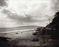
Anthony's Nose, Dromana, 1920.
.jpg)
See also
 In Spanish: Bahía Port Phillip para niños
