Wathaurong facts for kids
| Regions with significant populations | |
|---|---|
| Languages | |
| Wadawurrung, English | |
| Religion | |
| Australian Aboriginal mythology, Christianity | |
| Related ethnic groups | |
| Boonwurrung, Dja Dja Wurrung, Taungurung, Wurundjeri see List of Indigenous Australian group names |
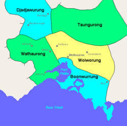
The Wathaurong people, also known as Wadawurrung, are an Aboriginal Australian group. They live in the area around Melbourne, Geelong, and the Bellarine Peninsula in Victoria. They are part of the Kulin alliance, which is a group of Aboriginal nations connected by culture and language. The Wathaurong language was spoken by 25 different family groups (clans). These clans lived south of the Werribee River and the Bellarine Peninsula, reaching as far as Streatham. People have lived in the Wathaurong area for at least 25,000 years.
Contents
Wathaurong Language
The Wathaurong language is part of the Pama-Nyungan language family. It belongs to the Kulin sub-branch of languages.
Wathaurong Lands
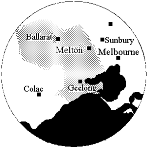
The Wathaurong people's traditional land covered about 7,770 square kilometers (3,000 square miles). East of Geelong, their land reached Queenscliff. South of Geelong, it went around the Bellarine Peninsula towards the Otway forests. To the northwest, their land extended to Mount Emu and Mount Misery. It also included Lake Burrumbeet, Beaufort, and the Ballarat goldfields.
Many signs of human activity have been found in this area. Over 140 archaeological sites show that people have lived here for at least 25,000 years.
Modern Wathaurong Groups
The Wathaurung Aboriginal Corporation helps represent the traditional owners of the land. They have been a Registered Aboriginal Party since 2009. This group works for the Geelong and Ballarat areas. The Wathaurong Aboriginal Co-operative, based in Geelong, also helps manage Wathaurong cultural heritage. For example, they own the Wurdi Youang Aboriginal stone arrangement at Mount Rothwell.
History of Contact with Europeans
Some Wathaurong groups living near the coast might have met Lieutenant John Murray. He mapped Indented Head and named Swan Bay. Later, Matthew Flinders met several Wathaurong people. This happened when he camped at Indented Head and climbed the You Yangs in May 1802. In October 1803, Lieutenant David Collins started a colony at Sullivan Bay, Victoria. He sent Lieutenant J. Tuckey to explore Corio Bay. During this exploration, some Aboriginal people were shot.
William Buckley was a convict who escaped from the Sullivan Bay settlement in December 1803. He lived with an Aboriginal group, believed to be the Wathaurong. Buckley shared stories of his time with them. He said he was adopted into the group and lived with them for 32 years. They treated him with great kindness and respect. The tribe thought he was Murrangurk, a past leader who had returned. Buckley said he helped settle disagreements between groups.
European settlement of Wathaurong land began in 1835. Many squatters quickly arrived around Geelong and to the west. The Aboriginal people resisted this invasion. They sometimes drove off or took sheep from the settlers. This often led to conflict.
The 1854 Eureka Rebellion happened on Wathaurong land. Three Wathaurong clans lived near the Eureka gold diggings. These were the Burrumbeet baluk, the Keyeet balug, and the Tooloora balug. The Native Police Corps helped control the early Ballarat Goldfields. They collected fees from gold miners. This led to clashes between the miners and the Gold Commissioner. Some historians believe these clashes were early signs of the Eureka Rebellion.
There is a story passed down through generations (oral history) that local Aboriginal people may have cared for some of the children of the Eureka miners. This happened after the military attacked the Eureka Stockade. Although there are no written records, historians think this story could be true.
George Yuille, an older brother of William Cross Yuille, was well-liked by the local Aboriginal people. He had a relationship with an Aboriginal woman and they had a child. George Yuille senior was a storekeeper on Specimen Hill. This means he was among the miners during the Eureka events. It is likely that the local Aboriginal people knew the miners well, especially if they were often in contact with George Yuille.
Willem Baa Nip was the last Wathaurong person to have seen the start of European settlement. Several important Wathaurong people from that early time, including Baa Nip, are buried in the Western Cemetery in Geelong.
Traditional Life and Customs
Wathaurong communities were made up of 25 land-owning groups called clans. These clans spoke a similar language and shared culture. They also traded with each other and formed marriage ties. Each clan had a leader. Among the coastal Wathaurong, this leader was called a n'arweet. For the inland northern tribe, the leader was a nourenit.
Sometimes, access to land and resources was limited for other clans. This happened if a resource, like fish in a river, was running low. The clan owning that resource would limit or stop fishing until the fish numbers recovered. During this time, people would find other foods. This helped make sure resources were used in a way that kept them available for the future. Like other Kulin groups, there were rules against trespassing. Today, traditional clan locations and borders are not used in the same way. Descendants of Wathaurong people live in modern society, but they still work to preserve their culture.
Wathaurong Clans
Before European settlement, there were 25 separate clans. Each had a leader.
| No | Clan name | Approximate location |
|---|---|---|
| 1 | Barere barere balug | Colac and "Mt Bute" stations |
| 2 | Beerekwart balug | Mount Emu |
| 3 | Bengalat balug | Indented Head |
| 4 | Berrejin balug | Unknown |
| 5 | Boro gundidj | Yarrowee River |
| 6 | Burrumbeet gundidj | Lakes Burumbeet and Learmonth |
| 6a | Keyeet balug | Mount Buninyong |
| 7 | Carringum balug | Carngham |
| 8 | Carininje balug | "Emu Hill" station, Linton's Creek |
| 9 | Corac balug | "Commeralghip" station, and Kuruc-a-ruc Creek |
| 10 | Corrin corrinjer balug | Carranballac |
| 11 | Gerarlture balug | West of Lake Modewarre |
| 12 | Marpeang balug | Blackwood, Myrniong, and Bacchus Marsh |
| 13 | Mear balug | Unknown |
| 14 | Moijerre balug | Mount Emu Creek |
| 15 | Moner balug | "Trawalla" station, Mount Emu Creek |
| 16 | Monmart | Unknown |
| 17 | Neerer balug | Between Geelong and the You Yangs (Hovells Ck?) |
| 18 | Pakeheneek balug | Mount Widderin |
| 19 | Peerickelmoon balug | Mount Misery area between Beaufort and Ballarat |
| 20 | Tooloora balug | Mount Warrenheip, Lal-lal Creek, west branch of Moorabool River. |
| 21 | Woodealloke gundidj | Wardy Yalloak River, south of Kuruc-a-ruc Creek |
| 22 | Wadawurrung balug | Barrabool Hills |
| 23 | Wongerrer balug | Head of Wardy Yalloak River |
| 24 | Worinyaloke balug | West side of Little River |
| 25 | Yaawangi | You Yang Hills |
Other Names for Wathaurong
- Bengali (a group near Geelong)
- Borumbeet Bulluk (a group at Lake Burrambeet with a slightly different way of speaking)
- Buninyong (a place name, where a northern group lived)
- Waddorow, Wadawio, Wadourer, Woddowrong, Wollowurong, Woddowro, Wudjawuru, Witowurrung, Wothowurong, Watorrong
- Wadjawuru, Wuddyawurru, Wuddyawurra, Witouro, Wittyawhuurong
- Wadthaurung, Waitowrung, Wudthaurung, Woddowrong
- Warra, Wardy-yallock (a group in the Pitfield area)
- Witaoro
- Witowro, Witoura
- Wudja-wurung, Witowurung, Witowurong
 | Percy Lavon Julian |
 | Katherine Johnson |
 | George Washington Carver |
 | Annie Easley |


