Mount Buninyong facts for kids
Quick facts for kids Mount Buninyong |
|
|---|---|

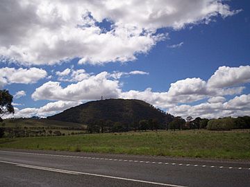
Mount Buninyong viewed from south at the Midland Highway east of Scotsburn
|
|
| Highest point | |
| Elevation | 719 m (2,359 ft) AHD |
| Geography | |
|
Lua error in Module:Location_map at line 420: attempt to index field 'wikibase' (a nil value).
|
|
| State/Province | AU |
Mount Buninyong is a really old volcano that's not active anymore. It's about 15 kilometres southeast of a city called Ballarat in Australia. This big hill is part of the Western Victorian Volcanic Plains.
Contents
Discover Mount Buninyong
What is Mount Buninyong?
Mount Buninyong is a huge extinct volcano. This means it won't erupt again. It stands 745 metres tall. The main part of the volcano, called a scoria cone, rises over 200 metres above the land around it. This makes it one of the biggest scoria volcanoes in Victoria. It also has a deep hole in the middle, which is its central crater.
The volcano erupted many times a long, long time ago. During one eruption, the west side of the volcano broke open. Later, lava flowed out through this opening. It's even possible this opening was another crater!
Exploring the Mountain
You can drive a road right up to the top of Mount Buninyong. At the summit, you'll see several communication towers. There's also a special tower used to watch for bushfires, which are wildfires in Australia.
If you like walking, there are three different tracks to explore:
- The Crater Walk takes you around the volcano's deep central hole.
- The Summit Walk leads you to the very top for great views.
- The Southern Walk explores the lower parts of the mountain.
Home for Koalas
Mount Buninyong is also one of the last places where koalas live in this area. You can find large manna gum and messmate trees there. These trees provide food and shelter for the koalas.
The Name's Story
The name Buninyong comes from the Australian Aboriginal people. They are the original inhabitants of Australia. The local Wauthaurung people had a word for the mountain: Bunnin Yowang. This word meant "big hill like knee".
 | Sharif Bey |
 | Hale Woodruff |
 | Richmond Barthé |
 | Purvis Young |

