Yarrowee River facts for kids
Quick facts for kids Yarrowee |
|
|---|---|

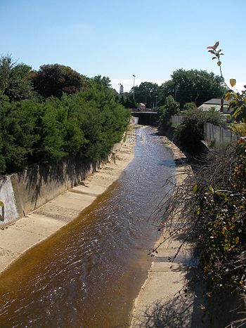
View of the Yarrowee River between Black Hill and East Ballarat west toward Peel Street. The Ballarat railway station clock tower is visible in the distance
|
|
| Country | Australia |
| State | Victoria |
| Region | Central Highlands |
| City | Ballarat |
| Physical characteristics | |
| Main source | Gong Gong Creek Gong Gong 520 m (1,710 ft) |
| River mouth | Leigh River Cambrian Hill, Victoria 377 m (1,237 ft) 37°37′48″S 143°49′54″E / 37.63000°S 143.83167°E |
| Length | 43 km (27 mi) |
| Basin features | |
| River system | Corangamite catchment |
| Tributaries |
|
The Yarrowee River, also known as Yaramlok in the local Aboriginal language, is a river in Victoria, Australia. It is part of the Corangamite water system. The river flows through the Central Highlands region.
Contents
Where the Yarrowee River Flows
The Yarrowee River is a main branch of the Barwon River. It starts in the hills near a place called Gong Gong. The river is special because it flows right through the city of Ballarat. It then continues through the City of Ballarat area. Finally, it joins the Leigh River near Cambrian Hill.
The Yarrowee River helps supply water to Ballarat. Many smaller streams, called tributaries, flow into it. These include Gnarr Creek and Gong Gong Creek in the north. In the south, you'll find Redan Creek and Canadian Creek.
The river passes through many suburbs of Ballarat. These include Nerrina, Brown Hill, and Ballarat East. It also flows through Ballarat Central, Golden Point, and Sebastopol. The river often forms a border between different suburbs.
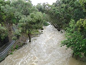
The Yarrowee is a seasonal river. This means its water levels change a lot. It often gets bigger in winter due to rain. Sometimes, it can even cause flash floods. But in dry times, the river and its smaller streams can dry up completely.
History of the Yarrowee River
Before European settlers arrived, the Yarrowee River was very important. The Boro gundidj people, a tribe of the Wathaurong Aboriginal people, lived near its northern parts. They used the river for their daily lives.
Long ago, where Ballarat is now, the river was clear and wide. It was full of native blackfish. The river would flow well until December. Then, it would become a series of ponds until the autumn rains returned.
Early settlers, called squatters, also found the river useful. William Cross Yuille built his home near a swamp connected to the river. This swamp is now Lake Wendouree. Bullock drivers, who moved goods, would camp by the river. Their animals could drink from a large waterhole.
The Ballarat gold rush changed the river a lot. Miners used its water for finding gold. In 1855, the first simple wooden bridge was built. This helped coaches cross the river.
As more settlers came, Aboriginal people were forced away from the river. In the 1860s, parts of the river were covered with bluestone drains. This was done to stop erosion and flooding. The river often flooded in those early days. In 1869, a big flood covered much of Ballarat's lower city. Two people lost their lives.
To help with flooding, the Gong Gong reservoir was built in 1877. By the early 1900s, the river became very polluted. This was due to the growth of industries in Ballarat.
In the 1960s, the river in Ballarat's city center was moved underground. It now flows under Grenville Street as a drain. Other parts of the river also became wide concrete drains. However, some parts of the river still look natural. They are surrounded by bush and parkland.
Since the 1980s, people have worked to clean up the river. They have planted new plants and brought back natural wetlands. The river still experienced flash floods in 2010 and 2011. The government has spent money to clean the river. But even in 2014, sewage problems were still an issue near Ballarat.
What's in a Name?
The first non-Aboriginal people called the river Yuille's Creek. This was after a local farmer, William Cross Yuille. The name Yarrowee likely comes from Yaramlok. This was the name given to the river by the Wathaurung people.
Some historians say Yaramlok means "gum tree growing in water." Other names for the river have been suggested. These include 'Nambrook' and 'Yar-ar-way'. Miners sometimes called it the 'Wee Yarrow'. This might be why some think the name comes from the Yarrow Water in Scotland. Many early settlers in the area were Scottish.
Bridges Over the Yarrowee
Many bridges cross the Yarrowee River. These include roads, railway lines, and paths for people walking. Some roads even let cars drive through shallow parts of the river when the water is low.
The river has many important crossings. For example, in Brown Hill, roads like Daylesford-Ballarat Road cross it. In Ballarat East, you'll find bridges like Scott Parade. In Sebastopol, the Whitehorse Road bridge was rebuilt after a flood in 2011. The Midland Highway crosses the river in Magpie.
 | Kyle Baker |
 | Joseph Yoakum |
 | Laura Wheeler Waring |
 | Henry Ossawa Tanner |


