
Kororoit Creek facts for kids
The Kororoit Creek is a natural waterway that flows through the western suburbs of Melbourne, in Victoria, Australia. It starts near Mount Kororoit and eventually flows into Altona Bay in Port Phillip Bay. This creek is important for the local environment and has a rich history.
Quick facts for kids Kororoit |
|
|---|---|

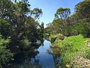
Kororoit Creek in Albion
|
|

Contour map of the Kororoit Creek and its tributaries, in Greater Melbourne.
|
|
| Country | Australia |
| State | Victoria |
| Region | Victorian Midlands (IBRA), Greater Melbourne |
| Local government areas | Melton, Brimbank |
| Suburbs | Rockbank, Caroline Springs, Burnside, Kings Park, Albanvale, Deer Park, Cairnlea, West Sunshine, Ardeer, Albion, Brooklyn, Altona North |
| Physical characteristics | |
| Main source | Mount Kororoit northeast of Melton 407 m (1,335 ft) 37°38′21″S 144°39′25″E / 37.63917°S 144.65694°E |
| River mouth | Altona Bay, Port Phillip Altona North 0 m (0 ft) 37°51′46″S 144°52′12″E / 37.86278°S 144.87000°E |
| Length | 52 km (32 mi) |
| Basin features | |
| River system | Port Phillip catchment |
| Tributaries |
|
| National parks | Altona Coastal Park, Jawbone Marine Sanctuary Park |
Contents
Where is Kororoit Creek?
The Kororoit Creek starts below Mount Kororoit, northeast of Melton. This is in the outer northwestern suburbs of Melbourne. The creek begins at about 400 metres (1,300 feet) above sea level.
How the Creek Flows
The creek flows generally from north to south. It crosses a flat area of land made from old volcanic lava. It ends at sea level, flowing into Altona Bay within Port Phillip. The creek is about 52 kilometres (32 miles) long. It drops about 407 metres (1,335 feet) from its start to its end.
Parks and Trails Along the Creek
Near its end, the creek flows through the Altona Coastal Park. It also passes through the Jawbone Marine Sanctuary Park before reaching Port Phillip. A popular path called the Kororoit Creek Trail runs along the creek's banks. This trail is great for walking and cycling.
Suburbs the Creek Passes Through
As the Kororoit Creek flows, it goes through many towns and suburbs. These include Rockbank, Caroline Springs, Burnside, {{VICcity|Kings Park]], {{VICcity|Albanvale]], {{VICcity|Deer Park]], Cairnlea, {{VICcity|West Sunshine]], {{VICcity|Ardeer]], {{VICcity|Albion]], {{VICcity|Brooklyn]], and Altona North.
Bridges and Roads
Several major roads cross the creek. These include the Melton Highway near Melton. The Western Highway and the Western Ring Road cross it at Ardeer. The West Gate Freeway and Federation Trail cross the creek at Brooklyn.
History of Kororoit Creek
The land around Kororoit Creek has a long and rich history.
Traditional Owners
The Wurundjeri people are the traditional custodians of this land. They have lived, hunted, and fished along the creek for thousands of years. You can still find many old tools and items left behind by them. There are also "scar trees" along the creek. These are trees where the Wurundjeri people carefully removed bark to make canoes.
European Exploration
European explorers, James Flemming and Charles Grimes, first recorded the Kororoit Creek in 1803. They also noted the Maribyrnong River and Yarra River at that time.
Brooklyn Bluestone Bridge
The Brooklyn Bluestone Bridge was built over the Kororoit Creek in the 1870s. It is located in Brooklyn. This bridge was made from local bluestone, a type of rock. It was one of the first bridges built for gold miners. These miners were traveling to the gold fields near Ballarat. The bridge is still standing today.
What Does "Kororoit" Mean?
The name Kororoit comes from an Aboriginal word. It is from the Woiwurrung language. It is thought to mean "creek on the western plain." Another idea is that the word means "male kangaroo."
Animals of Kororoit Creek
The Kororoit Creek is home to many interesting animals.
Reptiles and Amphibians
Important species like the growling grass frog and the striped legless lizard live here. You might also see native reptiles such as the tiger snake, eastern blue-tongued lizard, common snakeneck turtle, and eastern brown snake. Sadly, due to new buildings and development, these animals are not seen as often in some areas. These reptiles help keep the number of small mammals like water rats and mice in balance.
New wetlands and lakes have been created along the creek. Native frogs have moved into these new homes. The eastern banjo frog, common eastern froglet, and even the endangered growling grass frog have been found in these areas, especially in Cairnlea.
Fish and Aquatic Life
The creek's waters are home to various fish. These include the common galaxias, short-finned eel, Australian smelt, tupong, common carp, eastern bluespot goby, and flathead gudgeon.
Birds Along the Creek
Many types of birds can be seen near the creek. Some common ones are the Australasian darter, little pied cormorant, brown falcon, peregrine falcon, square-tailed kite, dusky moorhen, royal spoonbill, black swan, Pacific black duck, mallard, Australian wood duck, galah, rainbow lorikeet, white-faced heron, Australian white ibis, and wattlebird.
Animals No Longer Found Here
Sadly, two native species, the river blackfish and the platypus, are believed to be gone from the creek.
Introduced Species
Some animals that are not native to Australia can also be found near the creek. These include the red fox and the European rabbit.
Images for kids
-
Looking southwards down Kororoit Creek in Sunshine, south of Forrest St.
-
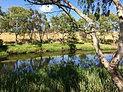
Eastern side of Kororoit Creek near Selwyn Park in Albion, looking southwards.
-
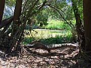
The western riverbank of Kororoit Creek, south of Forrest St.


