
Anthonys Nose (Victoria) facts for kids
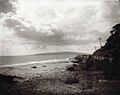
Anthony's Nose is a special spot on the southern side of Port Phillip Bay in Victoria, Australia. It's like a pointy cliff or a steep slope of land. You can find it between the towns of Dromana and McCrae.
.jpg)
Contents
What is Anthony's Nose?
Anthony's Nose is a natural landform, a bit like a nose sticking out! It's an escarpment, which means a long, steep slope or cliff. This particular one is found right on the edge of Port Phillip Bay.
How Did Anthony's Nose Get Its Name?
Who Named This Place?
The name "Anthony's Nose" was given by Charles La Trobe. He was an important person who became the Superintendent of the Port Phillip District in 1839.
Why Was It Called That?
Charles La Trobe thought this landform looked a lot like another place called Anthony's Nose in New York, USA. That one is on the Hudson River. So, he decided to give the Australian spot the same name!
Traveling Past Anthony's Nose in the Past
Early Challenges for Travelers
When European settlers first arrived in places like Dromana, traveling by land was quite hard. There were many natural obstacles. Journeys from Melbourne often meant crossing wet swamps and flowing streams.
Anthony's Nose was a tricky spot because Arthur's Seat mountain ended there. The mountain "fell steeply to the sea," meaning it dropped right down to the water.
High Tide Troubles
If you were traveling by foot, horse, or wagon, you had a problem at high tide. The only road followed the coastline. This meant you had to walk, ride, or drive through the water to get around the point. It was also hard to get past the rocks hidden underwater.
In 1845, a woman named Georgiana McCrae wrote in her journal about someone named Meyrick. He had to wait for the tide to go out before he could continue his journey with his bullock wagon. He even slept next to it while he waited!
Fishing and Local Life
Georgiana McCrae's diary also mentioned many fishing trips. Her husband, his workers, her sons, and the local Boon wurrung Aboriginal people often went fishing at Anthony's Nose. The Boon wurrung people were the first guardians of this land.
Building the Nepean Highway
Making Travel Easier
Over many years, the original steep slope of Anthony's Nose was cut back. It became more of a cliff face. This was done to make way for better roads.
The Engineer's Work
In the early 1920s, Anthony's Nose was cut back even more. An engineer named Mr. Alnutt was hired to finish this big job. His work helped build Point Nepean Road, which is now part of the famous Nepean Highway. This made travel much easier and safer for everyone.
Geological Features of Anthony's Nose
What Are the Rocks Like?
Colin McLear, whose family was one of the first to settle on the Mornington Peninsula, had some interesting ideas about the rocks at Anthony's Nose. He noticed that the stones visible in the man-made cutting looked like they had been shaped by water.
Theories About the Stones
He thought these stones might have been formed in a riverbed, like on the Hudson River. Or, they could have been shaped by waves on a shore. Before 1940, when a seawall was built, the shoreline at the "nose" was covered with these water-washed stones.
Port Phillip Bay's Past
Colin McLear was very interested in these ideas because Port Phillip Bay was once a huge flat plain. The Yarra River used to flow across it and might have joined the ocean near where Rye is today. The rocks under Arthur's Seat are made of Dromana granite. This granite is next to a geological feature called the Selwyn Fault.
Images for kids
-
Anthony's Nose, Port Phillip Bay: 1920
See Also
