Point Nepean facts for kids
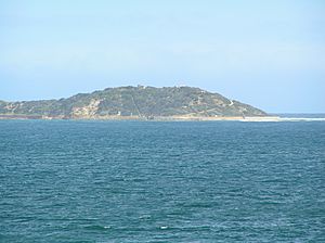
Point Nepean is a special place in Victoria, Australia. It's at the very tip of the Mornington Peninsula and marks the entrance to Port Phillip, called The Rip. It was named in 1802 by John Murray after a British politician, Sir Evan Nepean.
The waters around Point Nepean are part of the Port Phillip Heads Marine National Park. The land area is part of the Point Nepean National Park. On its southern side is Cheviot Beach. This beach is famous because Australia's Prime Minister, Harold Holt, disappeared there.
Contents
A Look Back in Time
Evidence shows that Australian Aboriginal people lived in this area about 40,000 years ago. Point Nepean was a special birthing place for women of the Bunurong People. There are 70 important Aboriginal sites found within the Point Nepean National Park.
Early British settlers mined limestone from the cliffs here. They built two lime kilns around 1840. A place called the Point Nepean Quarantine Station opened in 1852. It was used to check people arriving by ship for illnesses. This station is one of the oldest and most complete quarantine stations in Australia. It operated until 1980.
Australia's first big oil spill happened near Point Nepean in 1903. This was when the ship SS Petriana sank. It was the largest oil spill in Australia until 1975.
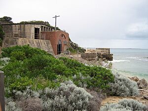
From 1878, strong forts were built at Point Nepean. Gun batteries were placed at Fort Nepean in 1886 and Eagles Nest in 1888. Another gun battery was built at Fort Pearce in 1911. After World War II, these military buildings were used as schools. They housed the Officer Cadet School (OCS) Portsea and later the School of Army Health until 1998.
The Land and Park
Parts of Point Nepean became a national park in 1988. The Australian Government offered to sell the land to the Victorian Government in 1998 and again in 2001. However, the state government did not accept the offer at first.
In 2002, the Department of Defence wanted to sell a large part of the land for building. This plan was stopped in 2003 because many people protested. Later, in 2004, much of the Defence land was given to a special trust. This trust managed the old Quarantine Station.
On June 8, 2009, the land was given to the Victorian government. The former Quarantine Station opened to the public in December 2009. It is now managed by Parks Victoria as part of the Mornington Peninsula National Park.
Military History
Point Nepean has a rich military history. Fortifications were built from 1878 onwards. These included gun batteries at Fort Nepean and Eagles Nest. Barracks were also built at Fort Pearce.
After World War II, these military sites changed purpose. They became home to the Officer Cadet School (OCS) Portsea from 1951 to 1985. Later, the School of Army Health was there until 1998. Many officer cadets graduated from OCS Portsea. Some even became officers in other countries' armies.
Some of the important historic military features you can still see include:
- Gun Junction — where you can see old gun barrel ruins and a guard house.
- Norris Barracks — these buildings were once part of the Quarantine Station.
- Point Nepean Cemetery (from 1854 to 1952).
- Cheviot Hill — with a World War II gun emplacement and observation post.
- Eagles Nest.
- Fort Pearce — including Pearce Barracks and gun emplacements.
- Fort Nepean — with its historic retaining wall, eight gun emplacements, an engine house, and tunnels.
Nature and Environment
The coast of Point Nepean has many interesting tide pools and reefs. These are home to a wide variety of sea creatures. You can find many different fish, invertebrates (animals without backbones), and other organisms. These include ascidians, sponges, and bryozoans.
Future Plans
The Victorian Government looked for ideas to develop the site in 2013/14. A local developer was chosen. Most of the historic buildings and other facilities will stay. The site will be turned into a health spa resort and offer different types of accommodation. There will also be cafes and a research facility for the University of Melbourne.
Images for kids
 | John T. Biggers |
 | Thomas Blackshear |
 | Mark Bradford |
 | Beverly Buchanan |


