Hogan Island facts for kids

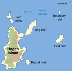
Map of the Hogan Group, showing the Hogan Island (left).
|
|
|
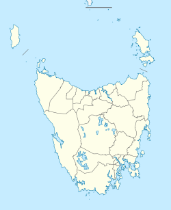
Location of the Hogan Island in Bass Strait
|
|
| Etymology | Michael Hogan |
|---|---|
| Geography | |
| Location | Bass Strait |
| Coordinates | 39°13′12″S 146°58′46″E / 39.22000°S 146.97944°E |
| Archipelago | Hogan Group |
| Area | 232 ha (570 acres) |
| Highest elevation | 116 m (381 ft) |
| Administration | |
| State | Tasmania |
Hogan Island is the biggest island in the Hogan Group. It's a granite island about 232 hectares in size. You can find it in the northern part of Bass Strait, which is a sea channel between Tasmania and Victoria, Australia. The island's highest point is 116 meters (381 feet) above sea level.
Contents
Island History and Features
Hogan Island, along with other islands in the Hogan, Kent, and Furneaux Group groups, was once part of a land bridge. This land bridge connected Tasmania to mainland Australia. This connection existed until the end of the Pleistocene period, a very long time ago. When the ice age ended, sea levels began to rise. The Hogan Group islands were the first to become separated from the mainland by these rising waters.
How Hogan Island Got Its Name
The islands were named in 1802 by John Black. He was the captain of a ship called the Harbinger. Captain Black named the islands after Michael Hogan, who owned his ship. The Harbinger was the first ship to sail through Bass Strait after it was discovered by Bass and Flinders.
Past Activities on the Island
After the islands were discovered, sealers often visited or lived on them. They hunted seals for their fur and oil. When there were fewer seals to hunt, the sealers started hunting kangaroos or farming.
The first official lease for Hogan Island was recorded on October 12, 1900. At first, the lease covered the entire island group. But since 1959, it has only applied to Hogan Island. From 1967, a person named B. R. Stackhouse held the lease. He used the island to graze cattle and sheep. However, this farming caused a lot of damage to the plants and natural springs on the island. Because of this, the grazing activities eventually stopped.
Amazing Animals of Hogan Island
Hogan Island is home to many interesting animals.
Seabirds and Waders
Many types of seabirds and waders (birds that wade in shallow water) come to Hogan Island to breed. These include:
- Little penguin
- Short-tailed shearwater, also known as the muttonbird
- Pacific gull
- Silver gull
- Sooty oystercatcher
Reptiles
You can also find several kinds of reptiles on the island. These include:
- Eastern blue-tongued lizard
- Metallic skink
- Three-lined skink
- Bougainville's skink
- White's skink
For some time, there were also wild goats living on the island.
Where States Meet: The Border Story
The border between the states of Tasmania and Victoria runs through the Hogan Group. It even crosses land on a small island called North East Islet. This means that Tasmania and Victoria actually share a small land border!
How the Border Was Decided
Before Victoria became its own colony, it was agreed that New South Wales would control all the land up to Bass Strait. Tasmania would control Bass Strait itself, except for the waters very close to the coast. The original plan was for all the Bass Strait Islands to be part of Tasmania. However, the surveyed position for Wilsons Promontory was slightly incorrect. This caused the border to be placed a bit too far south, at 39°12' S. Once this mistake was found, the North East Islet was renamed to Boundary Islet. The land border between the two states on this islet is about 85 meters (279 feet) long.
 | Aurelia Browder |
 | Nannie Helen Burroughs |
 | Michelle Alexander |


