Hogan Group facts for kids

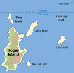
Map of the Hogan Group
|
|
|
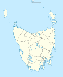
Location of Hogan Group in the Bass Strait, north of Tasmania
|
|
| Etymology | Michael Hogan |
|---|---|
| Geography | |
| Location | Bass Strait |
| Coordinates | 39°15′S 146°59′E / 39.250°S 146.983°E |
| Archipelago | Hogan Group |
| Total islands | 6-8 |
| Major islands | Hogan Island |
| Highest elevation | 130 m (430 ft) |
| Administration | |
|
Australia
|
|
| State | Victoria |
| State | Tasmania |
The Hogan Group is a small cluster of six to eight islands and tiny islets. They are located in the Bass Strait, a sea passage that separates mainland Australia from the island state of Tasmania. These islands are special because they help mark part of the border between Tasmania and the state of Victoria.
Even though they are in the Bass Strait, the Hogan Group is officially considered "unallocated Crown land". This means it's public land not yet assigned for a specific use. It falls under the local government areas of Flinders Municipality in Tasmania and the South Gippsland Shire in Victoria.
The Hogan Group includes several islands and islets. The main one is Hogan Island. Other parts of the group are Twin, Long, Round, East, Boundary (also called North East) islets, and Seal Rock.
Contents
Location and Geography of the Hogan Group
The Hogan Group is found about 40 kilometers (25 miles) southeast of Wilsons Promontory. This is a well-known peninsula on the coast of Victoria. The islands are made up of two main types of rock. These are grey and red granite, which is a hard, igneous rock, and limestone, which is a softer rock often formed from shells.
Wildlife on the Islands
The islands are home to various plants and animals. A group of fur seals lives on Boundary Islet. These are marine mammals known for their thick fur. You can also find different types of marine life around the islands. These include Cystophora intermedia, a type of brown algae, and eelgrass, which is a plant that grows underwater. Kelp, a large seaweed, and abalone, a type of sea snail, also live in the waters nearby.
History of the Hogan Group
The Hogan Group has a long and interesting history. During the Pleistocene period, which was a time of ice ages, these islands were not islands at all. They were part of a large land bridge. This land bridge connected Tasmania to mainland Australia.
How the Islands Formed
After the last major ice age ended, the climate became warmer. This caused sea levels to rise as glaciers and ice sheets melted. The Hogan Group was one of the first areas to become completely surrounded by water. This is how they turned into separate islands.
European Discovery and Naming
Europeans discovered the Hogan Group in 1801. John Black, who was the captain of a ship called the Harbinger, named the islands. He named them after Michael Hogan, who owned his ship.
Early Settlers and Land Use
Records show that people settled on the Hogan Group in the past. They hunted seals and kangaroos for food and resources. The islands were also used as grazing land for animals like sheep or cattle. On October 12, 1900, the first official lease was given for Hogan Island. A lease is like renting land for a long time.
Initially, this lease covered the entire island group. However, since 1959, the lease has only applied to Hogan Island itself. Since 1967, a person named B.R. Stackhouse has leased Hogan Island. He uses the island for raising sheep and cattle.
The Border Mistake
Captain Black made a mistake when he first surveyed the islands. He thought the Hogan Group was located further north than it actually is. This error later led to Boundary Islet becoming part of the land border between Victoria and Tasmania.
 | Valerie Thomas |
 | Frederick McKinley Jones |
 | George Edward Alcorn Jr. |
 | Thomas Mensah |


