North Esk River facts for kids
Quick facts for kids North Esk |
|
|---|---|

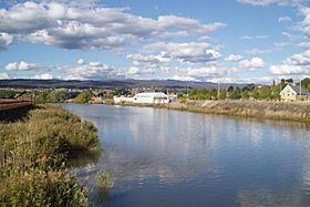
North Esk River from Victoria Bridge in Launceston
|
|

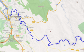
Course of the North Esk River.
|
|
| Native name | lakekeller; mangana |
| Country | Australia |
| State | Tasmania |
| Region | Northern Tasmania |
| Physical characteristics | |
| Main source | Ben Nevis Northallerton Valley 547 m (1,795 ft) |
| River mouth | South Esk River Launceston 0 m (0 ft) 41°43′16″S 147°13′06″E / 41.72111°S 147.21833°E |
| Length | 86 km (53 mi) |
| Basin features | |
| River system | South Esk River |
| Tributaries |
|
The North Esk River is a major river that flows all year round in northern Tasmania, Australia. It is an important part of the local environment and history.
Contents
Where is the North Esk River?
The North Esk River is one of the main rivers that feed into the Tamar River. The South Esk River is the other big one.
The North Esk starts in the Northallerton Valley. This area is found below Ben Nevis in Tasmania's North East. It then joins with the St Patricks River before flowing through the city of Launceston.
You can find Launceston's Old Seaport tourist area right on the North Esk River. After Hoblers Bridge, the river becomes tidal. This means its water level changes with the ocean's tides. The river sometimes floods, especially in parts of East Launceston.
Rivers that join the North Esk
The biggest river that flows into the North Esk is the St Patricks River. Other rivers that join it include the Ford River. The Ford River comes from the ski fields of Ben Lomond. The Roses Rivulet and Distillery Creek also flow into the North Esk.
History of the North Esk River
The North Esk River has a long and interesting history. It is important to both the Aboriginal people and European settlers.
Aboriginal history
The North Esk River area is part of the traditional lands of the Tasmanian Aboriginal people. The upper parts of the river belonged to the Ben Lomond Nation. The lower parts, near Launceston, were home to the Leterremairrener clan. They were part of the North Midlands Nation.
The Aboriginal names for the North Esk River were lakekeller and mangana. Lakekeller meant "deep," and mangana simply meant "river."
In 1831, an explorer described the land along the North Esk River. He said it was open country surrounded by thick forests. This open land was used by early settlers to hunt kangaroos. It was known as 'Bullock's Hunting Ground'. It is thought that Aboriginal people kept this land open using special burning techniques. This made it a good hunting ground for them.
Paterson's Plains, near what is now St Leonards, was a meeting place for Indigenous people.
European history
The North Esk River area has a rich but often forgotten history for Launceston. In early times, the river banks were busy with bushrangers and Aboriginal groups. They sometimes clashed with settlers in the area.
Further up the river, there was once a punt. A punt is a flat-bottomed boat used to ferry people or goods across a river. This punt was used before Hobler's Bridge was built in 1829. Many important Tasmanian farmers have lived along the North Esk over time. Some old properties, like 'Braemar' (from 1821) and 'Vermont' (from 1819), still stand near Launceston.
Until the early 1850s, convicts helped drain the river flats. This was done to stop the land from turning back into a swamp after floods. The river was also Launceston's main port. This was true until the Charles Street Bridge was built.
River facilities and industry
On the south bank of the river, near the Seaport, there were many wharves. Wharves are docks where ships load and unload goods. These wharves were used by flour mills, breweries, and woolsheds. They also served the Mt Mischoff Tin Smelters.
On the north bank, there were more wharves. These had a special crane that could load and unload trains directly. Further upstream, there were smaller wharves. One of these was the Dynamite Wharf. This wharf was used for a military storage area and shooting range.
These old military buildings are on Launceston's Glebe Flats. They include an explosives bunker (from the 1850s/1890s) and detonator sheds (from the 1850s). There is also a powder magazine and two ordnance sheds (from 1914). These buildings were used by the military until World War II. Today, they are on farmland and are protected as heritage sites.
 | Victor J. Glover |
 | Yvonne Cagle |
 | Jeanette Epps |
 | Bernard A. Harris Jr. |

