Schouten Island facts for kids
|
Schouten's Isle
|
|
|---|---|

Map of Schouten Island
|
|
|
Location of Schouten Island in Tasmania
|
|
| Etymology | In honour of Joost Schouten, a member of the Council of the Dutch East India Company; named in 1642 by Abel Tasman. |
| Geography | |
| Location | East coast of Tasmania |
| Coordinates | 42°18′36″S 148°16′12″E / 42.31000°S 148.27000°E |
| Archipelago | Schouten Island Group |
| Adjacent bodies of water | Tasman Sea |
| Area | 28 km2 (11 sq mi) |
| Highest elevation | 400 m (1,300 ft) |
| Highest point | Mount Storey |
| Administration | |
|
Australia
|
|
| State | Tasmania |
| Local government area | Glamorgan Spring Bay Council |
| Additional information | |
| Time zone | |
| • Summer (DST) | |
| Freycinet National Park | |
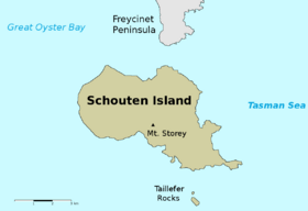
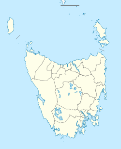
Schouten Island is a cool island off the eastern coast of Tasmania, Australia. It's about 28 square kilometers in size. The island is located just 1.6 kilometers south of the Freycinet Peninsula. It's also part of the amazing Freycinet National Park. The local Paredarerme name for the island is Tiggana marraboona.
The area called Schouten Island is part of the Glamorgan–Spring Bay region in Tasmania.
Contents
Island History and Discoveries
Schouten Island was originally home to the Oyster Bay tribe of Aboriginal Tasmanians. They lived on the island long before Europeans arrived. We know this because of special shell mounds called middens. These middens show where they used to eat and live.
Early European Visits
In 1642, a Dutch explorer named Abel Tasman was exploring the coast of Tasmania. He named the island after Joost Schouten, who was part of a big trading company called the Dutch East India Company.
Later, in 1802, explorers from the Baudin expedition also visited Schouten Island. In the early 1800s, people who hunted seals often came to the island. From the 1830s to the 1840s, there were even whaling stations on the island. These were places where people processed whales.
Mining and Farming
In 1809, a sealer named John Stacey found coal on the island. This led to mining for coal and tin between 1842 and 1925. In 1880, some Chinese miners also worked on the island looking for tin. John Stacey also thought that a large part of the island, about 200 to 300 hectares, could be used for farming.
After 1850, Schouten Island was used for grazing sheep. This means farmers let their sheep eat grass there. This continued until 1969.
Island Shape and Rocks
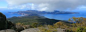
Schouten Island is a very rugged place. It has tall cliffs all around it. The highest point on the island is Mount Storey, which is 400 meters above sea level. There are also some sheltered bays where the cliffs break.
Geology of the Island
The island is split by a natural crack in the earth called a fault line. This line runs from north to south. The eastern part of the island is made of a type of rock called granite. The western part is made of dolerite rock. This dolerite sits on top of other rocks like sedimentary rocks.
Plants and Animals
Schouten Island is home to many different kinds of plants and animals.
Island Plants
The western part of the island has lots of eucalypt trees. These grow in the dolerite soil. The eastern part, with its granite soil, has different plants. Here you'll find scrubland, heathland, and sedge plants. Areas that were changed by humans in the past, like where land was cleared or sheep grazed, now have lots of grasses and small herbs.
Island Animals
Many birds live and breed on Schouten Island. These include cute Little penguins and short-tailed shearwaters. You might also spot the Tasmanian nativehen.
Australian fur seals like to rest on the eastern side of the island. The island is also home to several types of reptiles. These include the Tasmanian tree skink, the she-oak skink, the southern grass skink, and the three-lined skink.
 | Lonnie Johnson |
 | Granville Woods |
 | Lewis Howard Latimer |
 | James West |


