King River (Tasmania) facts for kids
Quick facts for kids King |
|
|---|---|

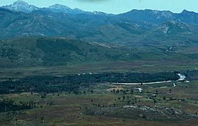
King River near Mount Huxley in the 1970s prior to damming. Frenchmans Cap is located in upper right corner of the photo.
|
|
| Country | Australia |
| State | Tasmania |
| Region | West Coast |
| Physical characteristics | |
| Main source | Thureau Hills, West Coast Range |
| River mouth | Lettes Bay, Macquarie Harbour near Strahan 0 m (0 ft) 42°11′35″S 145°21′13″E / 42.19306°S 145.35361°E |
| Length | 52 km (32 mi) |
| Basin features | |
| Tributaries |
|
| Reservoir | Lake Burbury |
The King River is a major river located in the West Coast area of Tasmania, Australia. It's known for its natural beauty and its history with mining and power generation.
Contents
Where is the King River?

The King River starts where two smaller rivers, the Eldon and South Eldon, meet. This happens near the Eldon Range in the West Coast Range mountains. The river flows for about 52-kilometre (32 mi) (32 miles). Along its journey, it's joined by nine other smaller rivers, called tributaries. These include the Queen River. Finally, the King River flows into Macquarie Harbour near a town called Strahan. From there, its waters mix with the Southern Ocean.
The upper part of the river flows through a valley shaped by ancient glaciers. You can still see marks left by these glaciers high up on the mountains. There are also small glacial lakes, like Lake Beatrice, on the eastern side of Mount Sedgwick.
King River Power Scheme
The King River is an important source of hydroelectric power. A large wall, called the Crotty Dam, was built across the river. This dam created a big lake called Lake Burbury, which covers about 54 square kilometres (21 sq mi) (21 square miles). The water from Lake Burbury is used to power the John Butters Power Station. This station creates electricity using the force of the flowing water.
When the dam was built, some old communities and parts of a railway line were covered by the new lake.
The Queen River and its Impact
For many years, the King River was considered one of Australia's most affected rivers due to mining. Mining began in the 1880s, and the Queen River, a main tributary of the King River, was used to dispose of waste from the Mt Lyell copper mine.
Between 1922 and 1995, leftover materials from processing ore, called tailings, were dumped directly into the river. About 1.5 million tonnes of these tailings entered the river system every year until 1995. Also, large amounts of acidic, metal-rich water flowed from the mine workings. This acid mine drainage happens when water flows through exposed rocks that contain sulfur. When the mine's smelter was operating, its fumes also caused acid rain, which washed more minerals from the nearby hills into the river.
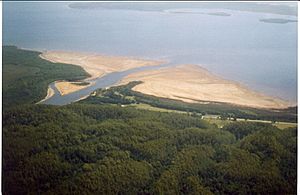
In 1992, the King River was dammed to create hydroelectric power. This changed how water flowed and how the tailings moved through the river system. About 100 million tonnes of tailings have built up along the banks and bed of the King River, and in a large fan-shaped deposit where the river enters Macquarie Harbour.
Since the mine closed in late 1995, and a special dam was built to hold the tailings, new waste no longer enters the river. However, acidic water still flows into the river from the mine. Without the old tailings to help balance the acidity, the water in the Queen and King rivers has become more acidic. This has increased the levels of dissolved metals, making the water very harmful for fish and other water creatures.
The Abt Railway
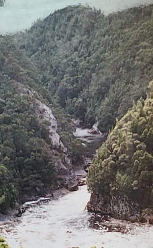
The lower part of the King River valley was once home to the "Abt" rack railway. This special railway was built to connect Queenstown to the coast. In 1962, the original railway closed down. However, it was rebuilt and reopened in 2002 for tourists. This new line follows the exact same path and is now known as the West Coast Wilderness Railway. It offers amazing views of the King River gorge.
 | Tommie Smith |
 | Simone Manuel |
 | Shani Davis |
 | Simone Biles |
 | Alice Coachman |


