
Eldon Range facts for kids
Quick facts for kids Eldon Range |
|
|---|---|

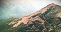
Eldon Peak (left side) from the air from the north, looking south towards Lake Burbury and West Coast Range on right
|
|
| Highest point | |
| Peak | Eldon Peak |
| Elevation | 1,440 m (4,720 ft) AHD |
| Geography | |

Eldon Peak
Location in Tasmania
|
|
| Country | Australia |
| Range coordinates | 41°58′48″S 145°46′12″E / 41.98000°S 145.77000°E |
| Geology | |
| Age of rock | Jurassic |
| Type of rock | Dolerite |
The Eldon Range is a group of mountains found in the west coast area of Tasmania, Australia. It sits on the north-eastern side of Lake Burbury.
This mountain range is part of the amazing Tasmanian Wilderness World Heritage Area. This special area is protected because it has unique natural beauty and important wildlife. It also includes the Franklin-Gordon Wild Rivers National Park. The Eldon Range is located east of the West Coast Range. It runs from west to east and is separated from the West Coast Range by the King River valley. The Eldon River flows to its north and west.
Contents
Why is it called Eldon Range?
The name "Eldon" has been used for mountains in Tasmania for a long time. In 1828, a person named Henry Hellyer might have used the name "Eldon" for what is now called Mount Farrell. He named it after Lord Eldon, who was an important judge in England. Later, in 1869, a geologist named Charles Gould gave the name "Eldon" to this specific mountain range.
Meet the Peaks of Eldon Range
The Eldon Range has several important peaks, or mountain tops.
Eldon Peak: The Highest Point
Eldon Peak is the highest point in the Eldon Range. It stands tall at about 1,440 meters (4,724 feet) above sea level. This peak is located on the western side of the range. It is also known as "number 23" in a list of Tasmania's highest mountains called "The Abels."
Eldon Bluff: The Eastern Peak
Another important peak is Eldon Bluff. This peak is on the eastern side of the range. It is about 1,361 meters (4,465 feet) high. Eldon Bluff is known as "number 54" in "The Abels" list.
Little Eldons: A Smaller Neighbor
South of the main Eldon Range, there is a smaller peak called the Little Eldons. It is about 640 meters (2,100 feet) high. The South Eldon River separates it from the main Eldon Range.
Exploring Eldon Peak
Eldon Peak is one of the hardest mountains to reach in Tasmania. This is because it is very remote, meaning it's far away from towns and roads.
In 1947, a Tasmanian bushwalker named Keith Lancaster climbed Eldon Peak. He found a pile of rocks, called a cairn, at the top. This showed that other people had climbed it before him. Keith Lancaster started his climb from the King River valley. However, this route is no longer possible because the river has been dammed.
Today, if you wanted to climb Eldon Peak, you would likely start from the south-east or south. You would aim for Lake Ewart, which is at the base of Eldon Bluff. All these routes involve walking over land where there are no clear paths. You might also encounter difficult patches of thick bushes.
Part of the path from the south-east follows the western edge of the Cradle Mountain-Lake St Clair National Park. This border was once marked with poles by a bushman named Charlie Spencer. However, most of these poles are now gone. This means that finding your way in this area can be very difficult, especially if the weather is bad.
Gallery
-
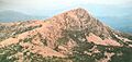
Eldon Peak seen from the south-east
-

Eldon Peak seen from the air, looking from the north
-
Eldon Peak seen from the west


