West Coast, Tasmania facts for kids
Quick facts for kids West CoastTasmania |
|||||||||||||||
|---|---|---|---|---|---|---|---|---|---|---|---|---|---|---|---|

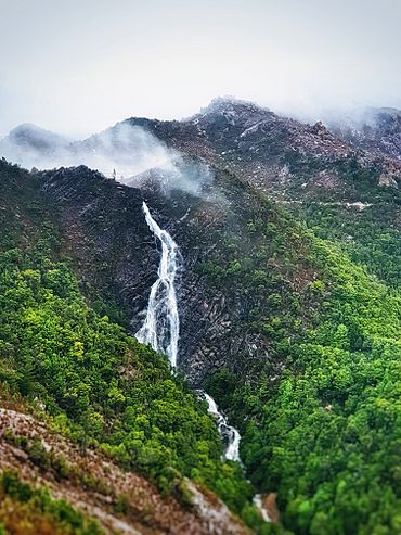
Horsetail Falls on Mount Owen
|
|||||||||||||||
| LGA(s) |
|
||||||||||||||
| State electorate(s) | Braddon | ||||||||||||||
| Federal Division(s) | Braddon | ||||||||||||||
|
|||||||||||||||
The West Coast of Tasmania is a special part of Tasmania, an island state in Australia. It's known for its wild, untouched nature and rugged landscapes. This area is famous for its wilderness, important mining history, and growing tourism.
Long ago, it was home to an early convict settlement. This makes it very different from the busier, more developed parts of Tasmania, like the north and east.

Contents
Discovering Tasmania's West Coast
The West Coast is a unique and exciting place to explore. It offers a glimpse into Tasmania's past and its amazing natural beauty.
Weather and Climate
The West Coast has a much cooler and wetter climate than Tasmania's east coast. Strong weather systems often hit the west coast. These bring lots of rain, and sometimes even snow and ice.
The West Coast Range mountains act like a shield. They stop these weather systems from reaching the east. This makes the West Coast a very rainy place. Some areas get over 2000 millimeters (about 79 inches) of rain each year!
Winter Weather
In winter, temperatures near the sea are usually around 10°C (50°F). When it's not raining, you might see frost in the mornings. Inland, away from the coast, temperatures are much colder. Winter highs often stay below 0°C (32°F).
Snow usually falls above 900 meters (3000 feet). But it can snow at sea level several times each winter.
Summer Weather
Summers on the West Coast are mild. The highest temperatures are usually between 17°C (63°F) and 21°C (70°F). However, some summer days can still be quite cool, staying below 10°C (50°F). Even though it's rare, snow has been known to fall in the middle of summer!
Getting Around and the Economy
For a long time, the West Coast was very isolated. It was hard for people from outside to understand this. Until the 1930s, the only way to get in or out was by sea. There were no good roads to the east or north until much later.
From the 1920s to the 1960s, railways were the main way to travel by land. These connected the West Coast to the north coast.
Dangerous Sea Travel
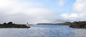
The entrance to Macquarie Harbour is called Hell's Gates. It's a very dangerous place for boats. Even today, with modern technology, sea travel along Tasmania's western side can be risky. Plaques at the Strahan wharf remember sailors who have been lost there.
Air Travel and Road Access
Today, the main airstrip is at Strahan. The airstrip at Queenstown is no longer used for regular flights. In the 1970s, a company called Airlines of Tasmania offered flights to the east coast.
Bad weather can often stop all transport services to the West Coast. Roads can be closed for days by ice and snow in winter. This means people can't get in or out.
History of Isolation
For many years, not much was written about how isolated these communities were. Or how they managed to live with these challenges. But after the 1990s, more books and articles appeared. These talked about the history and features of the region.
Tourism and Population
Tourism has grown a lot on the West Coast. The area also became famous because of the Franklin Dam controversy. This led to the creation of a world heritage wilderness area.
In the early 1900s, the West Coast had a large population. It even had as much political power as Hobart and Launceston. But after many mines in Zeehan closed, the population either stayed the same or got smaller compared to other parts of Tasmania.
The West Coast's Rich History
The West Coast has a deep and interesting history. Many parts of this history have been studied and written about.
Exploring the Land
The environment of the West Coast is described well by C.J. Binks. His book "Explorers of Western Tasmania" has a chapter called "A Sketch of the Western Country." This helps us understand the land. You can also learn more about the West Coast Range.
Convict Past
The time when convicts lived here is a big part of the history. You can find out more in articles about Macquarie Harbour Penal Station. Also, read about Convicts on the West Coast of Tasmania and the dangerous Hell's Gates.
Railways and Mining
Railways were very important for connecting the West Coast. You can learn about them in the article West Coast Tasmania Railways.
Mining has also shaped this region. Books like Geoffrey Blainey's "The Peaks of Lyell" tell this story. There's also a list of historical mines at West Coast Tasmania Mines. Many of these mines are now abandoned.
Forests and Piners
The West Coast has huge areas of forest. These include special trees like Huon Pine. These forests have faced fires and logging. But now, many areas are protected. The history of the West Coast Piners is important. These people used the Franklin River and Gordon River to transport timber.
Hydro Power
The Hydro Electric Commission (The Hydro) also has a complex history on the West Coast. From the 1940s to the 1980s, they saw the west and south-west as the last places to build power schemes.
Pictures of the Past
Since cameras were invented, many parts of the West Coast's history have been captured in photos.
The Queen Victoria Museum and Art Gallery and the State Library of Tasmania in Hobart have large collections of these photos. Eric Thomas's collection at the 'Galley Museum' in Queenstown is also very important.
Photo Collections
Here are some examples of books with photos of the West Coast:
- Hurley, Frank. Tasmania, A Camera Study John Sands, 1953
- Cox, G.W. and Ratcliff, E.V.R. Tasmania Remembered ( H.J. King ) Mary Fisher Bookshop, 1974. ISBN: 0-9599207-2-2
- Tassell, M. and Wood, D. Tasmanian Photographer (John Watt Beattie) Macmillan, 1981. ISBN: 0-333-33737-9
- Hopkins, D.L. The Golden Years of Tasmania St David's Park, 1991. ISBN: 0-7246-2536-4
- Morley, Les. The way we were The Author, 1997. Third Edition.
Modern Visuals
Since the 1990s, tourism has grown. Now, many DVDs and videos about the region are available. These often show places that were hard to reach just a few decades ago. Tourists and hikers also share many pictures and videos online.
Bioregion and Locality
The Tasmanian West bioregion includes both the West Coast region and the South West region. A bioregion is a large area of land or water that has similar plants, animals, and ecosystems.
The official "West Coast" locality is mostly an uninhabited area. It stretches between the Arthur River and Queenstown. This locality does not include the towns that are part of the wider West Coast region.
Local Government Areas
This specific locality is spread across several local government areas:
- Circular Head (34.6%)
- Kentish (0.3%)
- Waratah-Wynyard (27.1%)
- West Coast (38%)
Its center is about 137 kilometers (85 miles) west of Sheffield. In the 2016 census, the locality of West Coast had no permanent residents.
Neighboring Areas
The Southern Ocean forms part of the western border of this locality. It surrounds towns like Corinna, Renison Bell, Rosebery, and Zeehan. It also borders many other localities, including Arthur River, Cradle Mountain, Strahan, and Tullah.
Road Connections
The West Coast locality has several important road routes. These roads help people travel through this rugged area.
Main Highways
- A10 (Zeehan Highway / Murchison Highway): This road enters from Queenstown in the south. It goes north-west to Zeehan, then becomes the Murchison Highway. It continues north-east through Rosebery and then north, exiting to Guildford.
- B24 (Lyell Highway): At Queenstown, the Lyell Highway changes from A10 to B24. It runs south and west to Strahan, following part of the locality's southern border.
- B27 (Henty Road): This road enters from Zeehan and goes through the south-west corner to Strahan.
- B28 (Anthony Road): This road starts from the A10 and goes north-east to Rosebery, where it meets the A10 again.
Other Important Roads
- C252 (Pieman Road): Starts from the A10 in Rosebery and goes west to Lake Pieman.
- C249 (Heemskirk Road / Corinna Road / Norfolk Road): Enters from Zeehan as Heemskirk Road. It goes north-west and north to Lake Pieman. Then it becomes Corinna Road, continuing north through Corinna. After that, it becomes Norfolk Road and goes north until it meets C214.
- C214 (Blackwater Road / Rebecca Road): Starts from C218 on the northern border. It goes south and west before exiting to Couta Rocks.
- C218 (Roger River Road / Sumac Road / Rapid River Road / Tayatea Road / Trowutta Road): Enters from Roger River in the north. It forms a loop through the northern part of the locality before returning to Roger River.
- C247 (Corinna Road extension): Starts from C249 in Corinna and goes north-east, exiting to Savage River.
- C132 (Belvoir Road): Starts from the A10 and exits north-east to Guildford.
- C248 (Trial Harbour Road): Starts in Zeehan and goes south-west through the locality to Trial Harbour.
 | Laphonza Butler |
 | Daisy Bates |
 | Elizabeth Piper Ensley |


