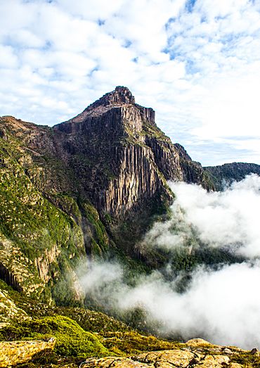
South West Tasmania facts for kids
Quick facts for kids South West TasmaniaTasmania |
|||||||||||||||
|---|---|---|---|---|---|---|---|---|---|---|---|---|---|---|---|

|
|||||||||||||||
| Population | 15 | ||||||||||||||
| LGA(s) |
|
||||||||||||||
| State electorate(s) | Lyons, Franklin | ||||||||||||||
| Federal Division(s) | Lyons, Franklin | ||||||||||||||
|
|||||||||||||||
South West Tasmania is a special part of Tasmania, an island state in Australia. For a long time, people have been curious about this wild and beautiful area.
At first, Europeans didn't explore much of this region. But in the mid-1900s, people started thinking about using its natural resources. Luckily, much of South West Tasmania is now protected. It's part of the amazing Southwest National Park and the Tasmanian Wilderness World Heritage Area. This means its unique nature is kept safe for everyone.
One of the biggest disagreements in this area happened in 1972. This was when Lake Pedder was flooded to build a hydro-electric power plant. Later, in the early 1980s, there was a plan to build a dam on the Franklin River further north. Many people protested, and the dam was never built. This helped protect the river.
The name "Southwest" also refers to a specific place, or locality, that covers most of this region. This locality is spread across several local government areas. These include Derwent Valley, Huon Valley, Central Highlands, and West Coast. The center of this locality is near Strathgordon. This spot is about 116 kilometers west of New Norfolk. In 2016, only 15 people lived in the Southwest locality.
Contents
Exploring South West Tasmania
Early explorers often walked through this region to discover new places. Some, like Thomas Bather Moore, even created tracks to make it easier for others to get around.
In 1927, a special walk happened between Cox Bight and Bathurst Harbour. Even the state's governor, Sir James O'Grady, joined this trip. They were looking for interesting rocks and geological information.
Where is South West Tasmania?
The Southern Ocean forms the western and southern edges of this area. The locality of Southwest surrounds the smaller area of Strathgordon. It also borders many other places. These include Macquarie Heads, Strahan, West Coast, Queenstown, Gormanston, Lake St Clair, Derwent Bridge, Butlers Gorge, Tarraleah, Wayatinah, Florentine, Maydena, Styx, Lonnavale, Geeveston, Raminea, Strathblane, Hastings, Lune River, and Recherche.
Roads in the Region
There are a few main roads that help people get around South West Tasmania.
- The A10 route, also known as the Lyell Highway, enters the region from Derwent Bridge in the northeast. It then heads northwest and leaves the area towards Queenstown.
- Route B61, called the Gordon River Road, comes in from Maydena in the east. It goes west through Strathgordon and ends at the Gordon Dam.
- Route C607, the Scotts Peak Dam Road, starts where it meets B61. It travels south and west, ending at Scotts Peak Dam.
Understanding the Region's Resources
After many people around the world became worried about South West Tasmania, the Australian government helped fund a big study. This study was called the South West Tasmania Resources Survey. It started in 1974 and received more money in 1977.
The survey created many reports and papers. These papers divided the region into different river areas, called catchments. Some of these important river catchments include:
- Franklin River
- Picton River
- Huon Weld
- Lake Gordon and Lake Pedder
- Lower Gordon
- Macquarie Harbour
- King River
- Mackintosh-Murchison
- Wanderer and Giblin
- Davey River
- Bathurst Harbour
- New River and South Coast
Ten years after this big survey, the Australia Heritage Commission published a list of important natural and cultural places in the South West. This helped to further protect the area.
 | Precious Adams |
 | Lauren Anderson |
 | Janet Collins |

